Carr, Colorado facts for kids
Quick facts for kids
Carr, Colorado
|
|
|---|---|

Post office in Carr
|
|
| Country | |
| State | |
| County | Weld County |
| Established | 1872 |
| Elevation | 5,712 ft (1,741 m) |
| Time zone | UTC-7 (MST) |
| • Summer (DST) | UTC-6 (MDT) |
| ZIP Code |
80612
|
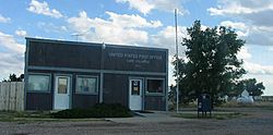
Carr is a small, unincorporated community in Weld County, Colorado, United States. An "unincorporated community" means it is not an official city or town with its own local government. It used to have a U.S. Post Office. The ZIP Code for Carr is 80612.
Some people once thought Carr was a ghost town. Today, a few old houses, a church, and a schoolhouse still stand. The old store buildings are gone, but you might find some old foundations. More people are now living in Carr year-round, so it no longer looks abandoned.
Contents
History
How Carr Began
The community of Carr was started in 1872 by the Union Pacific Railroad. It was named after Robert E. Carr, who helped build the railroad tracks through the area. The Carr Post Office first opened its doors on March 26, 1872.
Old Highway and Post Office Changes
From 1920 to 1939, Old Colorado State Highway 5 passed through Carr. This road was meant to provide access to the area. However, it was not a major cross-state highway.
The U.S. Post Office in Carr closed around 2021. This happened because the building it was renting became unsafe to use.
Recent Changes in Carr
One interesting building in Carr was a Geodesic Dome greenhouse. It was located just south of the old post office. This unique structure was taken down around 2022. This happened after new owners took over the post office building.
Also around 2022, County Road 21, also known as 2nd Street, was paved. This road goes from County Road 126 (Stevenson Avenue) to County Road 124. It is the first paved road in Carr that runs north and south.
Geography
Carr is located at coordinates 40°53′47″N 104°52′32″W / 40.89639°N 104.87556°W. This means it is at 40.896257 degrees North latitude and -104.875488 degrees West longitude.
Just north of the Carr turnoff on I-25, you can find the Carr Natural Fort. This is a natural rock formation made of limestone. It was a significant site where many battles took place between the Crow and Blackfeet Native American tribes.
The community sits in the bottom of the Lone Tree Creek valley. When you pass through, the valley might not seem very big. However, it is large enough to trap cold air in the winter. This can cause a temperature inversion, where cold air stays close to the ground.
 | John T. Biggers |
 | Thomas Blackshear |
 | Mark Bradford |
 | Beverly Buchanan |


