
Pawnee National Grassland facts for kids
Quick facts for kids Pawnee National Grassland |
|
|---|---|

The Pawnee Buttes in Pawnee National Grassland
|
|

Pawnee National Grassland
Location in the United States
|
|
| Location | Weld County, Colorado, United States |
| Nearest city | Greeley, Colorado |
| Area | 193,060 acres (781.3 km2) |
| Established | 1960 |
| Governing body | U.S. Forest Service |
| Website | Arapaho & Roosevelt National Forests and Pawnee National Grassland |
The Pawnee National Grassland is a special protected area in northeastern Colorado, USA. It's a huge open space on the Eastern Plains of Colorado. This grassland is found in Weld County, between the cities of Greeley and Sterling.
It covers about 193,060 acres, which is like 146,000 football fields! The grassland is made of two main parts. These parts are mostly located between State Highway 14 and the border with Wyoming. The eastern part even touches the borders of Nebraska and Wyoming. The U.S. Forest Service manages this area. They have an office in Fort Collins and a local ranger office in Greeley.
This grassland is in a very quiet part of the Great Plains. In the early 1900s, some people tried to farm here. But after the "Dust Bowl" in the 1930s, farming stopped to protect the land. Small towns like Keota and Purcell are inside the grassland. The town of Grover sits between the two big sections. Other nearby towns include Briggsdale and Stoneham. Water in the eastern part flows into Pawnee Creek. In the western part, water flows into Crow Creek.
Contents
Fun Activities and How to Visit
You can enjoy many outdoor activities at Pawnee National Grassland. Camping is available at the Crow Valley Recreation Area. This spot is located northwest of Briggsdale.
The grassland has several hiking trails. One trail leads to the Pawnee Buttes, which are famous rock formations. They are a must-see! Bird watching is also very popular here. Many people come to see the amazing birds, especially at the Chalk Bluffs Natural Area. This area is a special place where raptors (birds of prey) build their nests.
Over the past 10 years, some activities have changed due to oil and natural gas being found. The U.S. Forest Service says there are 63 active wells. Less than 3,000 acres of the grassland are fully protected from drilling.
Amazing Geology and Soils
The Pawnee National Grassland has two main types of soil. In the east, you'll find deep, dark, or reddish prairie soils. In the west, there are "chernozems," which are chestnut-colored soils that become brown. These chestnut soils are the most common type. They form in dry areas that get about 15 to 20 inches of rain each year. These soils are perfect for buffalo grass and blue grama.
Near the buttes, the soils are usually "brown soils." These soils are typical of cool, dry places and support short grasses and shrubs.
Water comes from an underground layer called an aquifer. This aquifer formed during the Cretaceous period, millions of years ago. There are three springs near the buttes that provide water. Most water is pulled up using windmill pumps. The aquifer gets refilled from the west and flows eastward. There are also other aquifers that get water from rain and streams.
The Shortgrass Prairie Ecosystem
The grassland is part of North America's shortgrass plains. The best examples of this unique ecosystem are found around the Pawnee Buttes. Here, grazing animals and farming have had less impact. There are eleven different plant zones in the grassland. The most special one is the "scarp woodlands" on the north side of the buttes. Here, you can find limber pines and other trees that are left over from the Ice Age.
The wildlife near the buttes is amazing! You might see pronghorn, deer, bison, prairie dogs, coyotes, rabbits, and many small rodents. Birds like the golden eagle and prairie falcons also nest here.
Different Plant Zones
- Short Grass Prairies: These cover the flat, open areas below the buttes. They are mostly covered by blue grama and buffalo grass. You might also see thread-leaf sedge, ring muhly, western wheatgrass, and prickly pear cactus. Western wheatgrass grows well in low, wet spots.
- Mixed Prairies: These are found on higher, sandier ground. They have needle and thread grass, western wheatgrass, and Junegrass. In spring and early summer, you'll see many colorful flowers like broom snakeweed and fringed sage. This zone has the most types of plants.
- Little Bluestem Areas: This grass is found all over the grassland. It grows best in sandy, gravelly soils and on north-facing slopes where the ground stays wet longer. Here, you'll find little bluestem mixed with Canada rye, phlox, and other grasses and flowers.
- Shrub Steppe: These areas are similar to short grass and mixed prairies but have more alkalinity (like salt). So, the fourwing saltbush grows very well here. You'll find these areas at the bottom of steep slopes. Other plants that like salty soil, like small soapweed, also grow here.
- Arroyos: These are deep, dry streambeds that form near steep slopes. They can be up to 30 feet deep! Even though there's no standing water, the soil holds moisture after it rains. This allows larger shrubs and small trees like Rocky Mountain juniper and choke cherry to grow. You might also see current and gooseberry bushes.
- Clay Barrens: These areas are made of eroding clay. Plants here need strong taproots to survive, like hooker sandwort. Some plants spread using underground stems called rhizomes, following cracks in the clay. Other plants include phlox, Indian rice grass, and evening primrose. Where the clay is actively eroding, no plants can grow.
- Break Shrubs: These are rocky areas, like cliff edges or rocky spots at the bottom of cliffs. Plants here need to hold on tight and have deep roots. You'll find skunk brush sumac and gooseberry bushes. You might also see mountain mahogany, little bluestem, and roses.
- Scarp Woodlands: These are found on the north-facing cliff edges and in narrow canyons. The canyons provide water and protection from the sun. This allows larger trees like limber pine and small ponderosa pines to grow.
- Willow Spring: This is the only natural water source near the buttes. Water-loving plants like peach-leaf willow and different types of sedges grow here.
- Bare Rocks: On bare rocks, only tough crustose lichens can grow.
- Road Edges: These areas get extra water from the road surface. Invasive plants like Russian thistle, veiny dock, and sweet clover often grow here. Native plants like Indian ricegrass also thrive.
Wildflowers of the Grassland
Wildflowers bloom from April through September in the Pawnee National Grassland. The best places to see these colorful flowers are near rocky areas or wet spots, especially around the Pawnee Buttes.
- Blue flax (Linum lewisii)
- Buffalo bur (Solanum rostratum)
- Cryptantha (Cryptantha species)
- Groundsel (Senecio species)
- Hartweg evening primrose (Calylophus hartwegii)
- Hood's phlox (Phlox hoodii)
- Narrow-leaved penstemon (Penstemon angustifolius)
- Nuttall's violet (Viola nuttallii)
- Pink cleome (Cleome serrulata)
- Plains prickly pear cactus (Opuntia polyacantha)
- Prairie coneflower (Ratibida columnifera)
- Prairie evening primrose (Oenothera albicaulis)
- Prairie onion (Allium textile)
- Prairie snowball (Abronia fragrans)
- Puccoon (Lithospermum incisum)
- Purple ground cherry (Quincula lobata)
- Salsify (Tragopogon major)
- Scarlet globe mallow (Sphaeralcea coccinea)
- Snow on the mountain (Agaloma marginata)
- Star lily (Leucocrinum montanum)
- Sunflowers (Helianthus species)
- Tansy aster (Machaeranthera tanacetifolia)
- Threadleaf yellowrays (Thelesperma filifolium)
- Tufted sandwort (Arenaria hookeri)
- Western wallflower (Erysimum spermum)
- Wooly locoweed (Astragalus mollissimus)
- Yucca (Yucca angustifolia)
Gallery
-
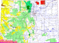
Colorado, with Pawnee National Grassland highlighted in red.
-
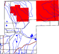
Weld County, Colorado with Pawnee National Grassland highlighted in red.
-
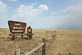
One of the signs marking the entrance to the grassland. This one is at the west side along State Highway 14.
-
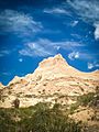
Rock formation near the Pawnee Buttes.
-
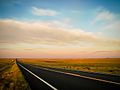
Sunrise over the grassland.
-
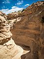
A gully near the Pawnee Buttes.
-
View of Pawnee National Grassland from County Rd 116 in February.
-
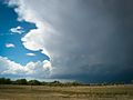
A thundercloud rolling in over the prairie.
-
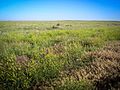
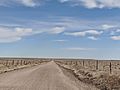
Uninterrupted prairie
-
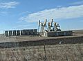
Oil wells on Colorado State Highway 14


