Stoneham, Colorado facts for kids
Quick facts for kids
Stoneham, Colorado
|
|
|---|---|

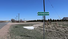
A view of Stoneham and Colorado State Highway 14.
|
|
| Country | |
| State | |
| County | Weld County |
| Elevation | 4,583 ft (1,397 m) |
| Population
(2020)
|
|
| • Total | 20 |
| Time zone | UTC-7 (MST) |
| • Summer (DST) | UTC-6 (MDT) |
| ZIP code |
80754
|
| Area code(s) | 970 |
| GNIS feature ID | 0182781 |
Stoneham is a small, quiet community in Weld County, Colorado, United States. It's not a city or town with its own government, but rather an unincorporated community. This means it's part of the larger county area. Stoneham has its own U.S. Post Office with the ZIP Code 80754. This post office has been serving the community since 1907.
Stoneham is located in northeastern Colorado. It is about 24 miles west of Sterling and 24 miles north of Brush. It's also about 43 miles south of Kimball, Nebraska, and 56 miles northeast of Greeley, Colorado.
Contents
History of Stoneham
Stoneham has an interesting past, especially with its connection to railroads.
Early Days and the Railroad
In 1887, the Chicago, Burlington, and Quincy Railroad built a railway line. This line connected Holdrege to Cheyenne. It passed right through the area where Stoneham would later be. The community of Stoneham was officially started in 1888.
However, the early years were tough. A severe drought hit the area. This made it hard for the community to thrive. Because of the drought, the local post office had to close. It was shut down from 1892 until 1907.
Train Travel and Changes
For many years, Stoneham was a stop for passenger trains. The Chicago, Burlington, and Quincy Railroad (CB&Q) had trains that ran between Sterling and Cheyenne. These trains, numbered 159 and 160, served Stoneham.
By 1951, a train ride from Stoneham to Cheyenne on train 159 took about 4 hours and 10 minutes. Traveling from Stoneham to Sterling on train 160 took about 103 minutes.
Passenger train service to Stoneham ended in 1971. This happened when Amtrak was created. Amtrak took over many passenger routes, and the CB&Q stopped its passenger services in many areas.
End of Rail Access
The railway line that once ran through Stoneham changed hands. It became owned by the Burlington Northern. However, by 1983, the railway was no longer used. The tracks were removed, leaving Stoneham without any train access.
Where is Stoneham?
Stoneham is located at coordinates 40°36′17″N 103°39′56″W / 40.60472°N 103.66556°W. This helps pinpoint its exact spot on a map.
The community is found near an important intersection of roads. These are Colorado State Highway 71 (SH 71) and Colorado State Highway 14 (SH 14). SH 71 goes between La Junta and the Nebraska border. SH 14 travels between Muddy Pass and Sterling.
 | Kyle Baker |
 | Joseph Yoakum |
 | Laura Wheeler Waring |
 | Henry Ossawa Tanner |


