Platteville, Colorado facts for kids
Quick facts for kids
Platteville, Colorado
|
|
|---|---|
|
Town
|
|

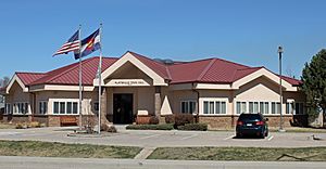
Platteville Town Hall
|
|
| Motto(s):
"Small Town Atmosphere, Big Town Vision"
|
|

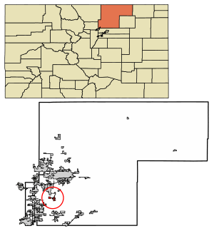
Location of Platteville in Weld County, Colorado.
|
|
| Country | |
| State | |
| County | Weld |
| Founded | 1871 |
| Incorporated (town) | January 1, 1887 |
| Government | |
| • Type | Statutory Town |
| Area | |
| • Total | 3.08 sq mi (7.99 km2) |
| • Land | 3.07 sq mi (7.96 km2) |
| • Water | 0.01 sq mi (0.03 km2) |
| Elevation | 4,813 ft (1,467 m) |
| Population
(2020)
|
|
| • Total | 2,955 |
| • Density | 959.4/sq mi (369.84/km2) |
| Time zone | UTC−7 (Mountain (MST)) |
| • Summer (DST) | UTC−6 (MDT) |
| ZIP code |
80651
|
| Area code(s) | 970 |
| FIPS code | 08-60160 |
| GNIS feature ID | 0180790 |
| Website | plattevillegov.org |
Platteville is a town in Weld County, Colorado, United States. It's called a "Statutory Town" because it follows general laws set by the state. In 2020, about 2,955 people lived there. Platteville is right next to Fort Vasquez on U.S. Highway 85.
Contents
History of Platteville
Platteville was started on May 27, 1871. It officially became a town on January 1, 1887. The town got its name because it is located near the South Platte River.
Geography and Location
Platteville is located at 40°12′52″N 104°49′27″W / 40.21444°N 104.82417°W. This means it's at 40.214468 degrees North latitude and -104.824070 degrees West longitude.
The town sits on the east side of the South Platte River. It's also where U.S. Highway 85 and State Highway 66 cross paths.
Just northwest of Platteville is the Fort St. Vrain Generating Station. This power plant used to be a nuclear power plant. Now, it uses natural gas to make electricity for homes and businesses. It's run by a company called Xcel Energy.
According to the United States Census Bureau, Platteville covers about 2.5 square miles (6.5 square kilometers) of land.
Population and People
Platteville has grown quite a bit over the years. Here's how its population has changed:
| Historical population | |||
|---|---|---|---|
| Census | Pop. | %± | |
| 1890 | 213 | — | |
| 1900 | 263 | 23.5% | |
| 1910 | 430 | 63.5% | |
| 1920 | 479 | 11.4% | |
| 1930 | 533 | 11.3% | |
| 1940 | 561 | 5.3% | |
| 1950 | 570 | 1.6% | |
| 1960 | 582 | 2.1% | |
| 1970 | 683 | 17.4% | |
| 1980 | 1,662 | 143.3% | |
| 1990 | 1,515 | −8.8% | |
| 2000 | 2,370 | 56.4% | |
| 2010 | 2,485 | 4.9% | |
| 2020 | 2,955 | 18.9% | |
In 2010, there were 2,485 people living in Platteville. The town had 951 households. Most people (about 73.84%) were White. About 35.19% of the population identified as Hispanic or Latino.
Many households (45.4%) had children under 18 living with them. The average household had about 3 people. The average age of people in Platteville was 30 years old.
Fun Events and Culture
Annual Harvest Daze Festival
Platteville has a special tradition called Harvest Daze. This festival celebrates the harvest season. It has been held every August since 1910! The name of the festival has changed over the years, but it's still a fun way to celebrate the end of summer.
See also
 In Spanish: Platteville (Colorado) para niños
 | Percy Lavon Julian |
 | Katherine Johnson |
 | George Washington Carver |
 | Annie Easley |

