
Fort Lupton, Colorado facts for kids
Quick facts for kids
Fort Lupton, Colorado
|
|||
|---|---|---|---|
| City of Fort Lupton | |||

Looking west along 1st Street in Fort Lupton.
|
|||
|
|||
| Motto(s):
"Where Tradition Builds the Future"
|
|||

Location of the City of Fort Lupton in Weld County, Colorado.
|
|||

Fort Lupton, Colorado
Location in the United States
|
|||
| Country | |||
| State | |||
| County | Weld | ||
| Government | |||
| • Type | Statutory City | ||
| Area | |||
| • Total | 12.199 sq mi (31.596 km2) | ||
| • Land | 12.146 sq mi (31.459 km2) | ||
| • Water | 0.053 sq mi (0.137 km2) | ||
| Elevation | 4,908 ft (1,496 m) | ||
| Population
(2020)
|
|||
| • Total | 7,955 | ||
| • Density | 655/sq mi (253/km2) | ||
| • Metro | 328,981 (156th) | ||
| • CSA | 3,623,560 (17th) | ||
| • Front Range | 5,055,344 | ||
| Time zone | UTC−07:00 (MST) | ||
| • Summer (DST) | UTC−06:00 (MDT) | ||
| ZIP code |
80621
|
||
| Area code(s) | 303 | ||
| FIPS code | 08-27700 | ||
| GNIS feature ID | 0180857 | ||

The City of Fort Lupton is a special type of city in southern Weld County, Colorado, United States. In 2020, about 7,955 people lived there. Fort Lupton is part of a larger area called the Greeley, Colorado Metropolitan Statistical Area. It is also part of the Front Range Urban Corridor, which is a long stretch of cities along the Rocky Mountains.
Contents
History of Fort Lupton
The city got its name from Lieutenant Lancaster Lupton. He built a trading post on Adobe Creek in 1838. This trading post was called Fort Lupton.
Today, you can visit a reconstructed version of the trading post. It is located near where the original fort stood. This historical site is part of the South Platte Valley Historical Park. The park teaches visitors about the early days of settlement in the area.
Geography and Location
Fort Lupton is located at 40°5′N 104°48′W / 40.083°N 104.800°W. This means it is in a specific spot on the map.
In 2020, the city covered an area of about 31.6 square kilometers (12.2 square miles). A small part of this area, about 0.14 square kilometers (0.05 square miles), is water.
Population and People
| Historical population | |||
|---|---|---|---|
| Census | Pop. | %± | |
| 1890 | 113 | — | |
| 1900 | 214 | 89.4% | |
| 1910 | 614 | 186.9% | |
| 1920 | 1,014 | 65.1% | |
| 1930 | 1,578 | 55.6% | |
| 1940 | 1,692 | 7.2% | |
| 1950 | 1,907 | 12.7% | |
| 1960 | 2,194 | 15.0% | |
| 1970 | 2,489 | 13.4% | |
| 1980 | 4,251 | 70.8% | |
| 1990 | 5,159 | 21.4% | |
| 2000 | 6,787 | 31.6% | |
| 2010 | 7,377 | 8.7% | |
| 2020 | 7,955 | 7.8% | |
| U.S. Decennial Census | |||
Over the years, the number of people living in Fort Lupton has grown. In 1890, only 113 people lived there. By 2020, the population had grown to 7,955 people.
In 2000, there were 6,787 people living in Fort Lupton. About 47% of the people identified as Hispanic or Latino.
The population was quite young. About 34% of the people were under 18 years old. The average age in the city was 29 years.
Schools and Education
Fort Lupton is part of the Weld County Public School District RE-8. This district includes several schools for different age groups.
- Fort Lupton Middle School
- Fort Lupton High School
- Butler Elementary
- Twombly Elementary
- Little Trappers Preschool
- Kenneth Homyak PK-8
In 2013, Fort Lupton High School had about 560 students in grades 9-12.
Famous People from Fort Lupton
Some well-known people have connections to Fort Lupton:
- Brian Shaw: He is a famous American strongman. He won the title of "World's Strongest Man" four times.
- John Naka: He was a Japanese-American bonsai grandmaster. He was born in Fort Lupton and lived there for his first eight years.
Images for kids
-

Looking west along 1st Street in Fort Lupton.
-

The flag of Fort Lupton.
-

The official logo of Fort Lupton.
-
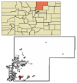
Map showing Fort Lupton in Weld County, Colorado.
See also
 In Spanish: Fort Lupton (Colorado) para niños
