
Nederland, Colorado facts for kids
Quick facts for kids
Town of Nederland
|
|
|---|---|
 |
|
| Motto(s):
"Life Is Better Up Here"
|
|

Location of Nederland in Boulder County, Colorado.
|
|
| Country | United States |
| State | Colorado |
| County | Boulder County |
| Incorporated (town) | November 15, 1885 |
| Government | |
| • Type | Statutory Town |
| Area | |
| • Total | 1.55 sq mi (4.01 km2) |
| • Land | 1.48 sq mi (3.83 km2) |
| • Water | 0.07 sq mi (0.18 km2) |
| Elevation | 8,235 ft (2,510 m) |
| Population
(2020)
|
|
| • Total | 1,471 |
| • Density | 1,035.81/sq mi (400.00/km2) |
| Time zone | UTC-7 (MST) |
| • Summer (DST) | UTC-6 (MDT) |
| ZIP code |
80466
|
| Area code(s) | 303 |
| FIPS code | 08-53175 |
| GNIS feature ID | 2413037 |
Nederland is a small town located in the mountains of Colorado, United States. It sits near the Barker Meadow Reservoir in the foothills of southwest Boulder County. In 2020, about 1,471 people lived there.
Contents
History of Nederland
Nederland was first settled in 1874. Before it became a town, it was a place where Ute Indians and early European settlers traded goods in the 1850s.
Early Discoveries and Growth
The town grew quickly when valuable minerals were found nearby. People discovered tungsten, silver, and gold in areas like Tungsten, Caribou, and Eldora. This led to an "economic boom," meaning the town's economy grew very fast.
How Nederland Got Its Name
In the mid-1800s, the area had a few different names, like Dayton and Browns Crossing. In 1871, the US Postal Service called it Middle Boulder, after the creek flowing through the town.
In 1873, a mine called Caribou was sold to a company from the Netherlands. The Dutch word for "Netherlands" is Nederland, which means "low land." Even though the mine was high in the mountains, the new owners decided to bring the mined rock down to Middle Boulder for processing. Because the Dutch miners often used the word "Nederland," the town became known by that name. In 1874, the town officially adopted Nederland as its name.
Nederland Today
Today, Nederland is known as a starting point for outdoor adventures. You can explore places like the Indian Peaks Wilderness, Rocky Mountain National Park, and Roosevelt National Forest. The town is about 17 miles west of Boulder and 47 miles northwest of Denver.
Geography of Nederland
Nederland is located in the southwest part of Boulder County. To the west of the town, you'll find the Indian Peaks Wilderness inside the Roosevelt National Forest. The Continental Divide, which separates rivers flowing to the Atlantic from those flowing to the Pacific, is about 8 miles west of Nederland.
The town covers about 1.55 square miles. Most of this area is land, but a small part is water, mainly the western end of Barker Reservoir.
Climate in Nederland
Nederland has a cold, snowy climate because it's very high up in the mountains. This type of climate is called an alpine subarctic climate.
Even in summer, nights can be cool, and it's possible for frost to appear. Snow can fall during most months of the year.
| Climate data for Nederland, Colorado (1970-1988) | |||||||||||||
|---|---|---|---|---|---|---|---|---|---|---|---|---|---|
| Month | Jan | Feb | Mar | Apr | May | Jun | Jul | Aug | Sep | Oct | Nov | Dec | Year |
| Record high °F (°C) | 65 (18) |
61 (16) |
65 (18) |
71 (22) |
78 (26) |
86 (30) |
87 (31) |
89 (32) |
82 (28) |
79 (26) |
70 (21) |
64 (18) |
89 (32) |
| Mean daily maximum °F (°C) | 34.9 (1.6) |
37.8 (3.2) |
41.8 (5.4) |
49.2 (9.6) |
57.5 (14.2) |
69.1 (20.6) |
75.2 (24.0) |
73.3 (22.9) |
65.3 (18.5) |
55.2 (12.9) |
43.1 (6.2) |
37.1 (2.8) |
53.2 (11.8) |
| Mean daily minimum °F (°C) | 10.2 (−12.1) |
12.9 (−10.6) |
16.7 (−8.5) |
22.7 (−5.2) |
29.3 (−1.5) |
37.1 (2.8) |
42.6 (5.9) |
41.2 (5.1) |
33.8 (1.0) |
25.3 (−3.7) |
17.5 (−8.1) |
12.5 (−10.8) |
25.2 (−3.8) |
| Record low °F (°C) | −30 (−34) |
−30 (−34) |
−30 (−34) |
−10 (−23) |
6 (−14) |
14 (−10) |
27 (−3) |
19 (−7) |
3 (−16) |
−2 (−19) |
−25 (−32) |
−34 (−37) |
−34 (−37) |
| Average precipitation inches (mm) | 0.54 (14) |
0.59 (15) |
1.29 (33) |
2.18 (55) |
2.69 (68) |
1.67 (42) |
2.39 (61) |
2.01 (51) |
1.74 (44) |
1.02 (26) |
1.12 (28) |
0.73 (19) |
17.97 (456) |
| Average snowfall inches (cm) | 13.3 (34) |
13.1 (33) |
23.9 (61) |
24.3 (62) |
12.2 (31) |
1.8 (4.6) |
0.0 (0.0) |
0.0 (0.0) |
5.2 (13) |
9.3 (24) |
19.9 (51) |
16.1 (41) |
139.0 (353) |
| Average precipitation days | 6 | 5 | 7 | 8 | 11 | 8 | 14 | 12 | 8 | 6 | 7 | 5 | 98 |
| Source: WRCC | |||||||||||||
| Weather chart for Nederland, CO | |||||||||||||||||||||||||||||||||||||||||||||||
|---|---|---|---|---|---|---|---|---|---|---|---|---|---|---|---|---|---|---|---|---|---|---|---|---|---|---|---|---|---|---|---|---|---|---|---|---|---|---|---|---|---|---|---|---|---|---|---|
| J | F | M | A | M | J | J | A | S | O | N | D | ||||||||||||||||||||||||||||||||||||
|
0.5
35
10
|
0.6
38
13
|
1.3
42
17
|
2.2
49
23
|
2.7
58
29
|
1.7
69
37
|
2.4
75
43
|
2
73
41
|
1.7
65
34
|
1
55
25
|
1.1
43
18
|
0.7
37
13
|
||||||||||||||||||||||||||||||||||||
| temperatures in °F precipitation totals in inches source: [1] |
|||||||||||||||||||||||||||||||||||||||||||||||
|
Metric conversion
|
|||||||||||||||||||||||||||||||||||||||||||||||
People of Nederland
| Historical population | |||
|---|---|---|---|
| Census | Pop. | %± | |
| 1880 | 279 | — | |
| 1910 | 446 | — | |
| 1920 | 291 | −34.8% | |
| 1930 | 285 | −2.1% | |
| 1940 | 384 | 34.7% | |
| 1950 | 266 | −30.7% | |
| 1960 | 272 | 2.3% | |
| 1970 | 492 | 80.9% | |
| 1980 | 1,212 | 146.3% | |
| 1990 | 1,099 | −9.3% | |
| 2000 | 1,394 | 26.8% | |
| 2010 | 1,445 | 3.7% | |
| 2020 | 1,471 | 1.8% | |
| U.S. Decennial Census | |||
In 2010, there were 1,445 people living in Nederland. These people lived in 657 households. About 28.5% of these households had children under 18.
The average household had about 2.19 people. The average family had about 2.77 people.
The town's population included people of different ages. About 19.8% were under 18. The median age was 39.5 years old. This means half the people were younger than 39.5 and half were older.
Arts and Culture in Nederland
Nederland hosts several fun events each year. These include the NedFest music and arts festival and the historical Miners Day celebration.
Frozen Dead Guy Days Festival
One of the most unique events is the annual Frozen Dead Guy Days festival. It happens every March near Barker Meadow Reservoir.
This festival celebrates a man named Bredo Morstoel. His grandson, Trygve Bauge, tried to preserve his body using a method called cryonics. The festival has become very popular and has even been featured in The New York Times.
Notable People from Nederland
- Kathy Butler, an Olympian runner for Great Britain and Canada
- Timothy Duggan, a road bicycle racer
- Ian MacGregor, a road bicycle racer
- Rob Savoye, a main developer of Gnash software
- Ann Trombley, an Olympic cyclist
- Carl Wilson, a singer and founding member of The Beach Boys
Images for kids
-
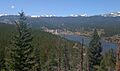
Barker Reservoir, a beautiful lake near Nederland.

See also
 In Spanish: Nederland (Colorado) para niños
