Superior, Colorado facts for kids
Quick facts for kids
Superior, Colorado
|
||
|---|---|---|

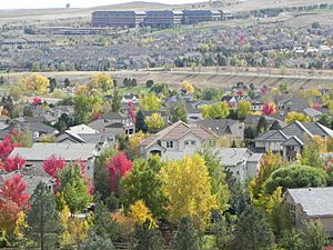
Rock Creek Ranch subdivision in Superior
|
||
|
||

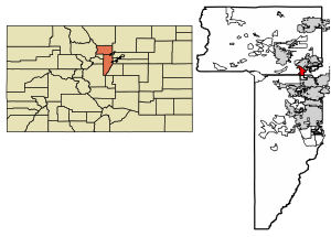
Location of Superior in Boulder County and Jefferson County, Colorado
|
||
| Country | ||
| State | ||
| Counties | Boulder County, Jefferson County | |
| Founded | 1896 | |
| Incorporated | June 10, 1904 | |
| Government | ||
| • Type | Statutory Town | |
| Area | ||
| • Total | 10.27 km2 (3.96 sq mi) | |
| • Land | 10.17 km2 (3.93 sq mi) | |
| • Water | 0.10 km2 (0.04 sq mi) | |
| Elevation | 1,683 m (5,522 ft) | |
| Population
(2020)
|
||
| • Total | 13,094 | |
| • Density | 1,275.0/km2 (3,307/sq mi) | |
| Time zone | UTC−7 (MST) | |
| • Summer (DST) | UTC−6 (MDT) | |
| ZIP code |
80027
|
|
| Area code(s) | Both 303 and 720 | |
| FIPS code | 08-75640 | |
| GNIS feature ID | 2413354 | |
| Highways | US 36, SH 128, SH 170 | |
| Website | Town Website | |
Superior is a town located in Boulder County, Colorado, United States. A very small part of the town's land also reaches into Jefferson County. In 2020, about 13,094 people lived in Superior. It is known as a "Home Rule Town," which means it has its own local rules and government, similar to a city.
Contents
History of Superior
Superior's story began with coal mining. The first mines in the area started in the late 1800s. People found coal on the Hake family farm in 1864. Stories from early families, like the Hakes, are kept at the Carnegie Library in Boulder. The town was named Superior because of its really good quality coal.
Mining Days and Growth
Mining was very important to Superior until the Industrial Mine closed in 1945. After that, many people moved away, and Superior became a quiet place for farming and ranching. The town's population stayed around 250 people for a long time. But in the late 1990s, new neighborhoods were built. This caused the population to grow a lot, reaching 9,011 by the year 2000.
Recent Events in Superior
Marshall Fire Disaster
On December 30, 2021, a huge fire called the Marshall Fire happened. It was the worst fire in Colorado's history. Over 1,000 homes were destroyed in Superior, the nearby city of Louisville, and other parts of Boulder County.
In Superior, about 378 homes were lost, and 58 were damaged. Seven business buildings were destroyed, and 30 were damaged. Sadly, two people also died in the fire.
The fire started in Boulder County and was pushed by very strong winds, up to 100 miles per hour. These winds blew the fire across very dry grass and plants into the town. The fire spread quickly and unexpectedly. About 13,000 people in Superior and 21,000 in Louisville had to leave their homes for safety.
After the fire, people in Superior began working hard to rebuild. They received help from the government and many local groups.
Airport Concerns
In 1960, the Rocky Mountain Metropolitan Airport (RMMA) opened near Superior. At that time, only about 175 people lived in Superior. The airport has grown bigger each year. Many flight schools have started operating there because more pilots are needed.
This growth has caused problems between Superior and the airport. The town of Superior has even filed a lawsuit against the airport. Superior had built new homes and schools close to the airport, even after being warned about noise and vibrations.
Becoming a Home Rule Town
On December 10, 2024, Superior held an election. The town voted to adopt a Home Rule Charter. This means Superior now has more control over its local laws and government.
Geography of Superior
Superior is located at coordinates 39.93119 degrees North and -105.159085 degrees West. It shares borders with the city of Louisville to the northeast and the city of Broomfield to the east and south. To the south is the Rocky Flats National Wildlife Refuge, and to the west is Boulder County open space.
Major roads near Superior include U.S. Highway 36, also called the Denver-Boulder Turnpike, which runs along the northeast side of town. Colorado Route 128A runs along the south.
Superior covers a total area of about 3.972 square miles. Most of this, about 3.933 square miles, is land. A small part, about 0.039 square miles, is water.
Climate in Superior
Superior has a dry, semi-arid, and cold climate. This means it gets less rain than some other places. The coldest temperatures in winter usually range from -10 to -5 degrees Fahrenheit.
| Climate data for Superior, Colorado. 1991-2020 | |||||||||||||
|---|---|---|---|---|---|---|---|---|---|---|---|---|---|
| Month | Jan | Feb | Mar | Apr | May | Jun | Jul | Aug | Sep | Oct | Nov | Dec | Year |
| Mean daily maximum °F (°C) | 46 (8) |
47 (8) |
55.4 (13.0) |
61.3 (16.3) |
70 (21) |
82.1 (27.8) |
88.3 (31.3) |
86.1 (30.1) |
78.4 (25.8) |
65.4 (18.6) |
53.8 (12.1) |
45.5 (7.5) |
64.9 (18.3) |
| Mean daily minimum °F (°C) | 20 (−7) |
21 (−6) |
28.1 (−2.2) |
34.2 (1.2) |
43.4 (6.3) |
52.8 (11.6) |
58.9 (14.9) |
56.7 (13.7) |
48.8 (9.3) |
36.8 (2.7) |
27.2 (−2.7) |
19.9 (−6.7) |
37.3 (2.9) |
| Average precipitation inches (mm) | 0.60 (15) |
0.75 (19) |
1.59 (40) |
2.49 (63) |
2.69 (68) |
1.67 (42) |
1.66 (42) |
1.55 (39) |
1.64 (42) |
1.30 (33) |
0.67 (17) |
0.67 (17) |
17.51 (445) |
| Source: PRISM Climate Group | |||||||||||||
Fun Things to Do in Superior
Superior has a lot of parks and open spaces, covering about 788 acres. This is about 31% of the town's total land. There are also almost 30 miles of trails for walking, running, and biking.
The town offers many fun activities:
- 13 playgrounds
- 6 pickleball courts
- 4 tennis courts
- 3 multipurpose fields
- 3 baseball/softball fields
- 2 outdoor swimming pools
- 3 basketball courts
- 2 sand volleyball courts
- 1 dog park
- 1 bike park
- 1 skate park
- 1 disc golf course
The Superior Community Center is a place where people can gather for different events and activities.
Population and People
| Historical population | |||
|---|---|---|---|
| Census | Pop. | %± | |
| 1910 | 349 | — | |
| 1920 | 233 | −33.2% | |
| 1930 | 160 | −31.3% | |
| 1940 | 205 | 28.1% | |
| 1950 | 134 | −34.6% | |
| 1960 | 173 | 29.1% | |
| 1970 | 171 | −1.2% | |
| 1980 | 208 | 21.6% | |
| 1990 | 255 | 22.6% | |
| 2000 | 9,011 | 3,433.7% | |
| 2010 | 12,483 | 38.5% | |
| 2020 | 13,094 | 4.9% | |
In 2022, there were about 13,146 people and 4,646 households in Superior. You can find more information about Superior's population from the US Census profile and US Census Quick Facts.
Age and Diversity
In 2022, about 27.4% of the people in Superior were under 18 years old. The average age was 36.9 years.
Most people in Superior are White (80.3%). About 19.4% are Asian, and 8.1% are Hispanic or Latino. About 20.9% of people speak a language other than English at home.
Homes and Income
Most homes in Superior (61.5%) are owned by the people who live in them. The average value of a home owned by its resident was about $603,600 between 2016 and 2020. The average rent for a home was about $2,060 during the same time.
The average income for a household in Superior was high, around $149,464 in 2022. This is much higher than the average for Colorado. Only about 2.2% of the population lived below the poverty line.
Education Levels
People in Superior have high levels of education. In 2022, almost everyone (97.8%) aged 25 and over had finished high school. A large number (76.3%) had a bachelor's degree or higher. This is much higher than the average for Colorado.
Businesses in Superior
Superior has many different kinds of businesses. These include large stores, a Tesla service center, and many other national and local shops. You can also find restaurants, service providers, and offices. In 2023, a new area called Downtown Superior was being built. It will have both shops and homes. The Superior Chamber of Commerce helps support all types of businesses in town.
Schools in Superior
Superior is part of the Boulder Valley School District (BVSD). The town has two public schools:
- Superior Elementary
- Eldorado PK-8
Older students usually go to Monarch High School in the nearby city of Louisville. However, students can also attend other schools in the Boulder Valley School District if there is space.
For higher education, there are several colleges nearby. These include the University of Colorado at Boulder, Naropa University in Boulder, and Front Range Community College campuses in Longmont and Westminster.
Notable People from Superior
- Marcelo Balboa – a famous soccer player
- Josh Sims – a well-known lacrosse player
Sister City
Superior has a special connection with a "sister city," which is a town in another country. This connection helps people from both places learn about each other's cultures.
 Khandbari, Koshi Province, Nepal
See also
 In Spanish: Superior (Colorado) para niños
 | Precious Adams |
 | Lauren Anderson |
 | Janet Collins |


