
Jamestown, Colorado facts for kids
Quick facts for kids
Town of Jamestown, Colorado
|
|
|---|---|
 |
|

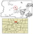
Location of Jamestown in Boulder County, Colorado.
|
|
| Country | USA |
| State | |
| County | Boulder |
| Incorporated (town) | June 22, 1883 |
| Government | |
| • Type | Statutory Town |
| Area | |
| • Total | 1.62 km2 (0.63 sq mi) |
| • Land | 1.62 km2 (0.63 sq mi) |
| • Water | 0.00 km2 (0.00 sq mi) |
| Elevation | 2,197 m (7,208 ft) |
| Population
(2020)
|
|
| • Total | 256 |
| • Density | 153.66/km2 (397.76/sq mi) |
| Time zone | UTC-7 (Mountain (MST)) |
| • Summer (DST) | UTC-6 (MDT) |
| ZIP code |
80455
|
| Area code(s) | 303 |
| FIPS code | 08-39195 |
| GNIS feature ID | 2412800 |
The historic Town of Jamestown is a small community in Boulder County, Colorado, United States. It is known as a "Statutory Town" because it follows specific state laws for its local government. In 2020, about 256 people lived in Jamestown.
The town was named after James Smith, who was an early gold prospector in the area. Jamestown faced a big challenge during the September 2013 Colorado floods. Heavy rains damaged roads, which cut off the town from the outside world. Many residents had to be rescued by helicopter by the Colorado National Guard. They were taken to safety in nearby Boulder.
Contents
Exploring Jamestown's Location
Jamestown is nestled in the middle of Boulder County, Colorado. It sits right along James Creek, within the beautiful Front Range of the Colorado Rockies. This area is known for its stunning mountain views.
You can reach Jamestown by taking James Canyon Drive. This road goes east for about 8 miles (13 km) to U.S. Highway 36 in Altona. It also goes west for about 6.5 miles (10.5 km) to State Highway 72, also known as the Peak to Peak Highway.
The town itself is quite small. It covers an area of about 1.6 square kilometers (0.6 square miles). All of this area is land, with no large bodies of water inside the town limits.
Who Lives in Jamestown?
The population of Jamestown has changed over the years. In 1890, 212 people lived there. The number went down for a while but then started to grow again. By 2010, the population was 274. In 2020, it was 256 people.
Jamestown's Community Life
In 2000, there were 96 households in Jamestown. A household is a group of people living together. About half of these households were married couples. Some households had children under 18 living with them.
The average household had about two people. The average family had almost three people. Most people living in Jamestown were White. A small number were Asian or Pacific Islander. Some people were of Hispanic or Latino background.
Age Groups in Jamestown
The people in Jamestown are of different ages. In 2000, about 19% of the population was under 18 years old. The largest group, about 46%, was between 25 and 44 years old. About 27% were between 45 and 64 years old. A smaller group, about 6%, was 65 years or older. The average age in town was 39 years old.
Income and Living in Jamestown
In 2000, the average income for a household in Jamestown was $67,500 per year. For families, the average income was $73,250. Men generally earned more than women. The average income per person in the town was about $29,904. A small number of families and people lived below the poverty line.
Images for kids
-

A view of Jamestown, Colorado.
-
Map showing Jamestown's location in Boulder County.
See also
 In Spanish: Jamestown (Colorado) para niños
