Strasburg, Colorado facts for kids
Quick facts for kids
Strasburg, Colorado
|
|
|---|---|

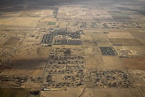
Aerial photo pf Strasburg
|
|

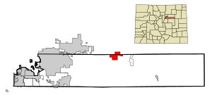
Location of the Strasburg CDP in Adams and Arapahoe County, Colorado.
|
|
| Country | |
| State | |
| County | Adams and Arapahoe |
| Government | |
| • Type | unincorporated town |
| Area | |
| • Total | 20.830 sq mi (53.949 km2) |
| • Land | 20.805 sq mi (53.885 km2) |
| • Water | 0.025 sq mi (0.064 km2) |
| Elevation | 5,420 ft (1,652 m) |
| Population
(2020)
|
|
| • Total | 3,307 |
| • Density | 158.763/sq mi (61.299/km2) |
| Time zone | UTC-7 (MST) |
| • Summer (DST) | UTC-6 (MDT) |
| ZIP Code |
80136
|
| Area codes | 303 & 720 |
| GNIS feature | Strasburg CDP |
Strasburg is a community in Colorado, located east of downtown Denver. It is called an "unincorporated town," which means it doesn't have its own city government like a mayor or city council. Instead, it's managed by the counties it's in.
Strasburg is also known as a census-designated place (CDP). This is a special area the government defines for counting people during the census. It helps them gather information about populations. Strasburg is located in both Adams and Arapahoe counties in Colorado, United States. It is part of the larger Denver–Aurora–Lakewood, CO Metropolitan Statistical Area. The local post office uses the ZIP Code 80136. In 2020, about 3,307 people lived in the Strasburg CDP.
History
The community of Strasburg was named after John Strasburg, who worked for the railroad. The town is built right next to a historic spot called the Comanche Crossing of the Kansas Pacific Railroad. This was a very important place in 1870. It's where the final spike was driven for the first transcontinental railroad in the United States. This railroad connected the East and West coasts!
A post office has been operating in Strasburg since 1908. Today, many people who live in Strasburg travel to nearby cities like Aurora, Brighton, and Denver for work. This makes Strasburg a "commuter community."
Geography
Strasburg is a CDP that covers an area of about 13,331 acres (53.949 km2). Most of this area is land, with only a small part, about 16 acres (0.064 km2), being water.
Population Information
The United States Census Bureau first officially defined Strasburg as a CDP for the United States Census 2000. This means they started counting its population separately from other areas.
| Strasburg CDP, Colorado | ||
|---|---|---|
| Year | Pop. | ±% |
| 2000 | 1,402 | — |
| 2010 | 2,447 | +74.5% |
| 2020 | 3,307 | +35.1% |
| Source: United States Census Bureau | ||
Education
Students in Strasburg attend schools that are part of the Strasburg School District 31J.
See also
 In Spanish: Strasburg (Colorado) para niños
 | Selma Burke |
 | Pauline Powell Burns |
 | Frederick J. Brown |
 | Robert Blackburn |


