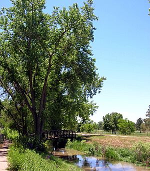
High Line Canal facts for kids
The High Line Canal (HLC) is a long, man-made waterway in Colorado. It was built to carry water for irrigation (watering crops and land). Today, it's also a very popular place for fun outdoor activities. The canal helps the cities of Denver and Aurora and the areas around them.
The High Line Canal starts at a special diversion dam on the South Platte River. This is about 1.8 miles (2.9 km) upstream from Waterton Canyon. From there, the canal flows mostly northeast for about 66 miles (106 km). It goes through Douglas, Arapahoe, Denver, and Adams Counties.
Contents
Why is it Called "High Line"?
You might think the High Line Canal is the only one with that name, but it's not! There are other canals in Colorado called "High Line," like the Farmer's High Line and the Government High Line. There are even more in other western states.
These canals get their name from how they are built. It's an engineering idea called the "high line principle." This means the canal is designed to follow the natural shape of the land. It drops very little in height over long distances. This way, water can flow using only gravity. No pumps or electricity are needed to move the water! Because of this, High Line canals often have many twists and turns. They go around hills and through valleys to keep a steady, high elevation.
Building the Canal: Early Challenges
When the High Line Canal was first planned, its builders wanted to water about 50,000 acres of farmland. But they had trouble getting enough water. Other canals built earlier already had rights to the water. This led to many court cases about water rights that lasted for years.
Because the High Line Canal was "junior" to 74 other canals, it often didn't get water when there wasn't much to go around. So, the big farming plans for the area didn't fully happen. However, the canal still helped Denver and its nearby city, Aurora, grow. In 1924, a company called Denver Water took over the canal.
How the Canal Waters Land Today
The High Line Canal was built to carry a huge amount of water, almost three-quarters of a billion gallons each day! But it usually carries much less, about 71 million gallons. Today, the canal can hold about 600 cubic feet (17 cubic meters) of water per second.
In 1942, when the Rocky Mountain Arsenal was built, a smaller channel was added to the High Line Canal. This channel supplied water to the Arsenal. Until about 2008, the Rocky Mountain Arsenal National Wildlife Refuge was the last place to get water from the canal.
However, the canal isn't the most efficient way to move water. Denver Water estimates that 60-80% of the water in the canal is lost. This happens because it soaks into the ground or evaporates into the air. Now, the Arsenal gets recycled water instead of canal water. As of 2011, the last customer to get water from the High Line Canal is Fairmount Cemetery. Still, Denver Water sometimes sends water further down the canal to keep the trees along its banks alive.
Fun on the High Line Canal Trail
Even though the High Line Canal was built for irrigation, most people in Colorado know it for recreation today. The canal and its water belong to Denver Water. For a long time, the path next to it was only for maintenance vehicles. But since 1970, about 60 miles (97 km) of this path have been made into a fun trail.
This trail is closed to cars, but it's open all year for people to enjoy. It's a popular spot for hikers, bikers, joggers, and even horseback riders in some areas. The High Line Canal Trail is a National Landmark Trail. Many parts of the trail are shaded by tall cottonwood trees. The path itself can be hard-packed dirt or concrete.
Even though Denver Water owns the canal, five different groups help take care of different parts of the trail:
| Group | Approx. distance | What it's like |
|---|---|---|
| Douglas County | 8.7 miles (14 km) | This part of the trail is dirt, and some spots can be sandy. |
| Highlands Ranch Metropolitan District | 7.1 miles (11.4 km) | Some parts are dirt, and others are hard-packed gravel. A section of this trail is concrete. |
| South Suburban Park and Recreation District | 19 miles (30.6 km) | Mostly hard-packed gravel. |
| Denver Parks and Recreation Department | 13.2 miles (21.2 km) | Most of this trail section is paved with asphalt. |
| Aurora Parks and Open Space | 13.7 miles (22 km) | Mostly concrete, but some parts are not maintained for public use. |
| Denver Parks and Recreation Department | 2.5 miles (4 km) | This entire section of the trail is paved with concrete. |
In 2009, a group called The Trust for Public Land helped protect 20 acres (81,000 square meters) of land next to the High Line Canal Trail. The canal also provides water to Buell Lake in Cherry Hills Village.
Wildlife Along the Canal
The High Line Canal and its surrounding trails are home to many different animals. You might spot deer, ducks, geese, and turtles. Birds like hawks, herons, and pelicans are also common. Other animals seen here include raccoons, foxes, coyotes, and even mountain lions!
 | Janet Taylor Pickett |
 | Synthia Saint James |
 | Howardena Pindell |
 | Faith Ringgold |


