
Platte Canyon facts for kids

The Platte Canyon is a beautiful, deep, and narrow valley carved by the South Platte River in the Rocky Mountains of Colorado. This amazing canyon is located southwest of Denver and sits on the border between Jefferson and Douglas counties. It's like a special doorway where the South Platte River leaves the mountains, passing through the Rampart Range and its hogbacks, and flows out onto the flat Eastern Plains. The lowest and narrowest part of this canyon is sometimes called Waterton Canyon.
Contents
Exploring Platte Canyon's Geography
The name "Platte Canyon" can mean a few different things. Sometimes, it refers to the entire section of the South Platte River and its North Fork that runs through the mountains, from a place called South Park all the way to the eastern plains. It can also refer to the small towns located along the North Fork, close to Bailey.
Waterton Canyon: A Hidden Gem
The very narrowest part of the canyon is a wild and remote area known as Waterton Canyon. It's about 8 miles (13 kilometers) long and doesn't have any roads. This section stretches between the small community of South Platte and Kassler, where the river finally leaves the mountains. In this part, the canyon walls rise impressively, about 1,000 feet (300 meters) from the riverbed!
The river itself drops quite a bit in elevation here. It goes from about 6,100 feet at South Platte down to about 5,500 feet at the canyon's mouth. You can also find a diversion dam in this area. This dam holds back water in the South Platte River, allowing some of it to be sent into the High Line Canal for other uses.
Railroad History in Platte Canyon

In the mid-to-late 1870s, a company called the Denver, South Park and Pacific Railroad built the very first railway through Platte Canyon. This railway continued through the valley of the North Fork, reaching South Park and eventually extending to towns like Leadville and Gunnison.
The Narrow Gauge Line
This railway line was initially a narrow gauge track, which means the tracks were closer together than standard tracks. Later, the line was taken over by the Colorado and Southern Railway. However, train service on this historic line eventually stopped in 1937.
Plans for a Dam in the Canyon
In the late 1920s, the Denver Board of Water Commissioners suggested building a large dam that would flood a big part of Platte Canyon. However, this plan was not approved by the Public Utilities Commission.
Strontia Springs Reservoir
Even though the original large dam wasn't built, a section of Waterton Canyon, about 1.7 miles long, was eventually flooded. This happened when the Strontia Springs Reservoir was completed in 1983. This reservoir is part of a bigger project called the Foothills Project, which helps manage water for the area.
Images for kids
-
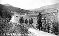
The South Park Highway cut through the Platte Canyon in the early 1900s. (Park County Local History Digital Archive)
-
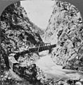
Railroad in Platte Canyon, Colorado ~ 1923

.jpg)
