
Gunnison, Colorado facts for kids
Quick facts for kids
Gunnison, Colorado
|
|
|---|---|

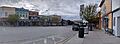
Storefronts along Main Street in Gunnison.
|
|
| Motto(s):
"Base Camp of the Rocky Mountains"
|
|

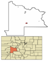
Location of the City of Gunnison in Gunnison County, Colorado.
|
|

Gunnison, Colorado
Location in the United States
|
|
| Country | |
| State | |
| County | Gunnison County |
| Incorporated | March 1, 1880 |
| Named for | John W. Gunnison |
| Government | |
| • Type | Home Rule Municipality |
| Area | |
| • Total | 4.849 sq mi (12.558 km2) |
| • Land | 4.849 sq mi (12.558 km2) |
| • Water | 0 sq mi (0.000 km2) |
| Elevation | 7,710 ft (2,350 m) |
| Population
(2020)
|
|
| • Total | 6,560 |
| • Density | 1,353/sq mi (522/km2) |
| Time zone | UTC−07:00 (MST) |
| • Summer (DST) | UTC−06:00 (MDT) |
| ZIP codes |
81230-81231 and 81247
|
| Area code(s) | 970 |
| FIPS code | 08-33640 |
| GNIS feature ID | 2410674 |
Gunnison is a city in Gunnison County, Colorado. It is the main city and the county seat of the county. In 2020, about 6,560 people lived there. The city is named after John W. Gunnison. He was a U.S. Army officer who explored the area in 1853. He was looking for a good path for a transcontinental railroad.
Gunnison is also known as a college town. It is home to Western Colorado University. This is the oldest university in the Colorado Western Slope region.
Contents
History of Gunnison
Early Days and Founding
Gunnison got its name from John W. Gunnison. He was the first known European-American explorer in the area. He visited in 1853 while looking for a railroad route. He only stayed for three days.
In the early 1800s, fur trappers and mountain men came to the Gunnison area. They tried to make a living from the Rocky Mountains. But fur prices dropped in the 1840s. This made their jobs less needed.
In the late 1850s, people started looking for gold in Gunnison County. This led to problems with the Ute people who lived there. Some miners were killed by Ute tribes. This made some miners leave the area.
Growth in the Late 1800s
The number of people in Gunnison grew a lot in the 1870s. This was because of the mining boom. Ranchers and farmers also moved in. This led to the Ute people being forced out of the area. Mines in Gunnison produced a lot of gold. The biggest amounts came from silver-lead ore.
The railroad reached Gunnison in 1880. Two railroad companies, D&RG and DSP&P, both wanted to control the town. The town was split into two sides. They argued about where the train stations should be. In the end, both lines came through town. The D&RG line was very important for about 70 years. It was the main way people traveled until the 1950s.
The cattle industry also started in Gunnison in 1880. Farmers realized the land was not great for growing crops. This was due to low rainfall and a short growing season. So, they started raising cattle instead. They cleared fields for grazing. They also dug irrigation ditches to grow hay for animals. Many of these farming methods are still used today.
John and William Outcalt were early settlers. They started a ranch north of town. John built an irrigation system for their ranch. He grew hay and other grains. He even paid for a railroad track to run through his property. This stop was called Hay Spur. They shipped over 800 carloads of hay each year. This hay mostly went to feed mules in Crested Butte, Colorado. They also sent potatoes and other vegetables.
John Outcalt was a very famous man in Gunnison. He helped build the Paragon School. This school still stands today at the Gunnison Pioneer Society museum. He was also trusted by the local native people. They even saved his life many times, according to stories.
20th and 21st Centuries
In late 1918, Gunnison residents tried to protect themselves from the Spanish Influenza. They blocked all roads near the county lines for two months. Train conductors warned passengers not to get off the train in Gunnison. If they did, they would be arrested and kept away from others for five days. This event partly inspired the book The Last Town on Earth. The isolation worked at first. But people became restless. The isolation ended in February 1919. The flu arrived a month later and two people died.
Geography
.JPG)
Gunnison covers about 12.5 square kilometers (4.8 square miles) of land. It is located near Blue Mesa Reservoir. You can reach Gunnison mainly by U.S. Highway 50. This road comes from Salida to the east or Montrose, Colorado to the west. Other roads to Gunnison may close during certain seasons. In 2010, the county had a population of 15,324 people.
Climate
Gunnison is in a valley in the Rocky Mountains. Cold air often settles into the valley at night. This makes Gunnison one of the coldest places in the United States in winter. This is especially true when there is snow on the ground.
The city usually gets a moderate amount of snow. It averages about 45.5 inches (116 cm) per year. Snow can fall from November to April. The mountains around Gunnison get much more snow. This snow is good for water supplies and local ski resorts. Gunnison gets about 10.6 inches (27 cm) of rain each year.
Gunnison has a climate called "warm-summer humid continental." The hottest temperature ever recorded was 105°F (41°C) in August 1894. The coldest was -47°F (-44°C) in December 1924.
| Climate data for Gunnison, Colorado, 1991–2020 normals, extremes 1893–present | |||||||||||||
|---|---|---|---|---|---|---|---|---|---|---|---|---|---|
| Month | Jan | Feb | Mar | Apr | May | Jun | Jul | Aug | Sep | Oct | Nov | Dec | Year |
| Record high °F (°C) | 55 (13) |
61 (16) |
75 (24) |
78 (26) |
87 (31) |
96 (36) |
95 (35) |
105 (41) |
92 (33) |
82 (28) |
75 (24) |
62 (17) |
105 (41) |
| Mean maximum °F (°C) | 41.1 (5.1) |
45.7 (7.6) |
58.9 (14.9) |
70.5 (21.4) |
78.4 (25.8) |
84.9 (29.4) |
87.2 (30.7) |
84.4 (29.1) |
80.5 (26.9) |
73.0 (22.8) |
59.5 (15.3) |
45.4 (7.4) |
86.6 (30.3) |
| Mean daily maximum °F (°C) | 26.1 (−3.3) |
30.4 (−0.9) |
44.1 (6.7) |
56.0 (13.3) |
65.8 (18.8) |
76.2 (24.6) |
79.9 (26.6) |
77.0 (25.0) |
70.3 (21.3) |
59.8 (15.4) |
43.6 (6.4) |
28.5 (−1.9) |
54.8 (12.7) |
| Daily mean °F (°C) | 9.8 (−12.3) |
15.6 (−9.1) |
29.0 (−1.7) |
39.3 (4.1) |
48.0 (8.9) |
56.3 (13.5) |
61.9 (16.6) |
59.8 (15.4) |
51.9 (11.1) |
40.7 (4.8) |
27.1 (−2.7) |
12.8 (−10.7) |
37.7 (3.2) |
| Mean daily minimum °F (°C) | −6.4 (−21.3) |
0.7 (−17.4) |
14.0 (−10.0) |
22.7 (−5.2) |
30.2 (−1.0) |
36.5 (2.5) |
43.9 (6.6) |
42.6 (5.9) |
33.6 (0.9) |
21.7 (−5.7) |
10.7 (−11.8) |
−2.9 (−19.4) |
20.6 (−6.3) |
| Mean minimum °F (°C) | −23.7 (−30.9) |
−17.6 (−27.6) |
−2.8 (−19.3) |
11.3 (−11.5) |
19.4 (−7.0) |
28.0 (−2.2) |
35.2 (1.8) |
34.3 (1.3) |
22.2 (−5.4) |
9.1 (−12.7) |
−5.9 (−21.1) |
−21.0 (−29.4) |
−26.8 (−32.7) |
| Record low °F (°C) | −45 (−43) |
−44 (−42) |
−29 (−34) |
−14 (−26) |
7 (−14) |
15 (−9) |
23 (−5) |
24 (−4) |
9 (−13) |
−11 (−24) |
−26 (−32) |
−47 (−44) |
−47 (−44) |
| Average precipitation inches (mm) | 0.82 (21) |
0.67 (17) |
0.51 (13) |
0.74 (19) |
1.00 (25) |
0.57 (14) |
1.31 (33) |
1.45 (37) |
1.22 (31) |
0.73 (19) |
0.65 (17) |
0.93 (24) |
10.60 (269) |
| Average snowfall inches (cm) | 11.1 (28) |
9.0 (23) |
4.4 (11) |
3.5 (8.9) |
0.6 (1.5) |
0.0 (0.0) |
0.0 (0.0) |
0.0 (0.0) |
0.2 (0.51) |
1.2 (3.0) |
5.2 (13) |
10.3 (26) |
45.5 (114.91) |
| Average precipitation days (≥ 0.01 in) | 7.4 | 6.5 | 4.9 | 5.3 | 6.5 | 4.8 | 10.1 | 10.7 | 8.8 | 6.1 | 5.1 | 6.4 | 82.6 |
| Average snowy days (≥ 0.1 in) | 8.2 | 7.1 | 4.2 | 3.1 | 0.6 | 0.0 | 0.0 | 0.0 | 0.0 | 1.1 | 4.0 | 7.2 | 35.5 |
| Source 1: NOAA | |||||||||||||
| Source 2: National Weather Service | |||||||||||||
Population and People
| Historical population | |||
|---|---|---|---|
| Census | Pop. | %± | |
| 1880 | 888 | — | |
| 1890 | 1,105 | 24.4% | |
| 1900 | 1,200 | 8.6% | |
| 1910 | 1,026 | −14.5% | |
| 1920 | 1,329 | 29.5% | |
| 1930 | 1,415 | 6.5% | |
| 1940 | 2,177 | 53.9% | |
| 1950 | 2,770 | 27.2% | |
| 1960 | 3,477 | 25.5% | |
| 1970 | 4,613 | 32.7% | |
| 1980 | 5,785 | 25.4% | |
| 1990 | 4,636 | −19.9% | |
| 2000 | 5,409 | 16.7% | |
| 2010 | 5,854 | 8.2% | |
| 2020 | 6,560 | 12.1% | |
| U.S. Decennial Census | |||
In 2010, Gunnison had 5,854 people living in 2,318 households. About 20.6% of households had children under 18. Most people (86.9%) were White. About 14.2% of the population was Hispanic or Latino.
The average age in Gunnison was 25.2 years. Many people were young adults, with 23.4% aged 20 to 24. The median income for a household was about $39,181. About 30.6% of the population lived below the poverty line.
Education

Gunnison is home to Western Colorado University. This college was first founded in 1901 as The Colorado State Normal School for Children. Its name changed over time. In 2012, it became Western Colorado University. It was the first liberal arts college on the Colorado Western Slope.
The Gunnison Valley also has the Gunnison Watershed RE1J School District. This district includes public and non-public schools. Public schools are in Gunnison and Crested Butte. Marble Charter School is in Marble.
Here are some of the public schools in Gunnison:
- Gunnison Elementary School
- Gunnison Kindergarten at Lake School
- Gunnison Middle School
- Gunnison High School
- Crested Butte Community School
- Gunnison Pre-School
- Marble Charter School
There are also non-public schools in Gunnison County. They offer a program of learning that includes reading, writing, math, history, and science.
Media and Film
Gunnison has a weekly newspaper called Gunnison Country Times. There are also local radio stations. KWSB-FM (91.1) is connected to Western Colorado University. KBUT (90.3 FM) also plays NPR shows.
Gunnison in Films
The silent film The Girls in the Overalls from 1902 was set on the Vidal Ranch in Gunnison.
Gunnison County is also where the science fiction movie Aliens vs. Predator: Requiem takes place. However, the movie was filmed in Canada. The film ends with the town being destroyed by a nuclear bomb.
Transportation

The Gunnison–Crested Butte Regional Airport serves the area. It has flights for both regular travelers and small planes.
The Gunnison Valley Rural Transportation Authority (RTA) runs a bus service. It connects Gunnison to Crested Butte. This bus goes to Western Colorado University and Crested Butte Mountain Resort. Gunnison is also part of the statewide Bustang system. This system connects the town to Denver.
Gunnison has been recognized for being bicycle-friendly. The League of American Bicyclists gave it a silver award.
Fun Activities

Gunnison offers many fun things to do all year round.
Winter Activities
In winter, you can go skiing at Crested Butte Mountain Resort or Monarch Ski Area. Other activities include:
- Snowmobiling
- Cross-country skiing
- Backcountry skiing
- Ice fishing
- Ice skating
- Hunting
- Snowshoeing
Summer Activities
During summer, you can enjoy:
- Fishing on the Gunnison River, Tomichi Creek, and Blue Mesa Reservoir.
- Hiking in many nearby areas like Curecanti National Recreation Area.
- Biking, both road biking and mountain biking. Hartman Rocks has many trails for mountain biking.
- Rafting down the Gunnison River from Almont to Gunnison.
- Visiting the whitewater park on the Gunnison River.
Gunnison also has festivals and farmers markets in the summer. You can get maps and information about trails and other interesting places from the Gunnison Ranger District Office.
Cattlemen's Days Rodeo
Gunnison hosts a famous rodeo called Cattlemen's Days. It lasts for 10 days in July. It features PRCA Rodeo events. There are also many family-friendly activities. In 2011, it was nominated as one of the top five "Mid-sized rodeo of the year" events. This rodeo also raises money for breast cancer research. It also offers scholarships to students involved in 4-H and FFA.
Famous People from Gunnison
- Donna Anderson (born 1939), an actress
- Susan DeMattei (born 1962), a U.S. Olympic cyclist
- Rebecca Dussault (born 1980), a U.S. Olympic cross-country skier
- Elva Dryer (born 1971), a U.S. Olympic long-distance runner
- Patricia Elliott (1938–2015), an actress
- Dan Gibbs (born 1976), a Colorado state politician
- Martin Hatcher (1927–2023), a Colorado state senator and college professor
- Herschel M. Hogg (1853–1934), a U.S. Representative from Colorado
- Sally Jacobsen (c. 1947–2017), a journalist
- Ila Mae McAfee (1897–1995), a painter and illustrator
- Aaron Simpson (born 1974), a mixed martial arts fighter
Images for kids
-
Storefronts along Main Street in Gunnison.
-
Location of the City of Gunnison in Gunnison County, Colorado.
-
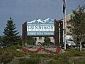
Welcome to Gunnison sign for travelers on Hwy 50 entering Gunnison from the east.
-
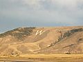
View of Tenderfoot Mountain taken from Gunnison in September 2009. The "W" signifies Western Colorado University.
-
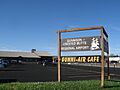
Gunnison–Crested Butte Regional Airport
-
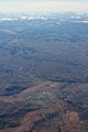
An aerial view of Gunnison.
See also
 In Spanish: Gunnison (Colorado) para niños
