Gunnison County, Colorado facts for kids
Quick facts for kids
Gunnison County
|
|
|---|---|
|
|
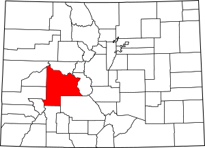
Location within the U.S. state of Colorado
|
|
 Colorado's location within the U.S. |
|
| Country | |
| State | |
| Founded | March 9, 1877 |
| Named for | John W. Gunnison |
| Seat | Gunnison |
| Largest city | Gunnison |
| Area | |
| • Total | 3,260 sq mi (8,400 km2) |
| • Land | 3,239 sq mi (8,390 km2) |
| • Water | 21 sq mi (50 km2) 0.6%% |
| Population
(2020)
|
|
| • Total | 16,918 |
| • Density | 5.2/sq mi (2.0/km2) |
| Time zone | UTC−7 (Mountain) |
| • Summer (DST) | UTC−6 (MDT) |
| Congressional district | 3rd |
Gunnison County is a county located in the U.S. state of Colorado. In 2020, about 16,918 people lived there. The main town and county seat is Gunnison. The county is named after John W. Gunnison. He was an Army officer who explored the area in 1853. He was looking for a good path for a railroad across the country.
Contents
History of Gunnison County
Early People and Explorers
The Ute people lived in the Gunnison area a very long time ago. Archeologists think they arrived around 1150 A.D. They might even be related to people who lived there in 1500 B.C. The Ute were nomadic, meaning they moved around. They followed animals and seasons across western Colorado.
In the 1600s, Spanish people from New Mexico brought horses. This changed how the Ute hunted. They could travel further, even into areas where other tribes lived.
The first recorded trip into this part of Colorado was in 1765. Don Juan Rivera led this Spanish group. Later, in 1776, two Spanish priests, Fathers Escalante and Domínguez, explored nearby areas.
Mountain Men and Gold Rush
In the 1830s, mountain men came to the area. They trapped beavers for their fur. Old cabins and forts from this time show their presence.
In 1853, Captain John W. Gunnison surveyed the area. He was looking for a route for the first transcontinental railroad.
Gold was found near Denver in 1858. This brought many people to western Colorado. They hoped to find gold themselves. In 1859, a group settled in Union Park. More gold was found at Washington Gulch in 1861. This was part of the Colorado Gold Rush.
Forming the County
In 1861, the Territory of Colorado was created. The government tried to make treaties with the Ute people. These treaties set aside land for them. They also promised goods and supplies. However, the government often did not keep its promises. This caused problems.
Chief Ouray became the main leader for seven Ute tribes. He worked hard to keep peace. In 1876, Colorado became a state. That same year, Gunnison County was officially formed.
By 1879, many miners and adventurers came to the county. They were looking for wealth. The cattle industry also grew by 1880. Farmers had to build irrigation systems. This helped them grow hay for their cattle.
Geography of Gunnison County
Gunnison County is very large. It covers about 3,260 square miles. Most of this is land, with a small amount of water. It is the fifth-largest county in Colorado.
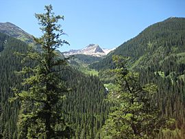
The county seat, Gunnison, Colorado, is in a wide valley. Two rivers, Tomichi Creek and Gunnison River, meet there. The county is surrounded by mountains and forests. These include the Continental Divide to the east. The Maroon Bells–Snowmass Wilderness is to the north. The West Elk Wilderness is to the west.
Taylor Park Reservoir is a large lake in the county. It was made by building the Taylor Dam in 1934.
Neighboring Counties
Gunnison County shares borders with many other counties:
- Pitkin County, Colorado — north
- Chaffee County, Colorado — east
- Saguache County, Colorado — southeast
- Hinsdale County, Colorado — south
- Ouray County, Colorado — southwest
- Delta County, Colorado — west
- Montrose County, Colorado — west
- Mesa County, Colorado — northwest
Main Highways
Several important roads run through Gunnison County:
 U.S. Highway 50
 State Highway 92
 State Highway 114
 State Highway 133
 State Highway 135
 State Highway 149
People of Gunnison County (Demographics)
| Historical population | |||
|---|---|---|---|
| Census | Pop. | %± | |
| 1880 | 8,235 | — | |
| 1890 | 4,359 | −47.1% | |
| 1900 | 5,331 | 22.3% | |
| 1910 | 5,897 | 10.6% | |
| 1920 | 5,590 | −5.2% | |
| 1930 | 5,527 | −1.1% | |
| 1940 | 6,192 | 12.0% | |
| 1950 | 5,716 | −7.7% | |
| 1960 | 5,477 | −4.2% | |
| 1970 | 7,578 | 38.4% | |
| 1980 | 10,689 | 41.1% | |
| 1990 | 10,273 | −3.9% | |
| 2000 | 13,956 | 35.9% | |
| 2010 | 15,324 | 9.8% | |
| 2020 | 16,918 | 10.4% | |
| 2023 (est.) | 17,321 | 13.0% | |
| U.S. Decennial Census 1790-1960 1900-1990 1990-2000 2010-2020 |
|||
In 2020, the population of Gunnison County was 16,918 people. The median age was about 35.7 years old in 2010. This means half the people were younger and half were older.
Most people in Gunnison County are White. About 8.2% of the population identified as Hispanic or Latino in 2010.
Education in Gunnison County
Schools for Kids (K-12 Education)
The Gunnison Watershed School District RE-1J serves the county. It has schools in Gunnison, Crested Butte, and Marble.
Colleges and Universities (Higher Education)
Gunnison County is home to Western Colorado University. This public university is in the city of Gunnison. About 3,500 students attended WCU in the 2022-2023 school year.
Fun Things to Do (Recreation)
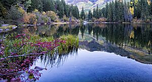
Gunnison County offers many outdoor activities. It has beautiful natural areas to explore.
State Parks
- Paonia State Park
National Recreation Areas
National Forests
- Gunnison National Forest
- White River National Forest
National Wilderness Areas
- Collegiate Peaks Wilderness
- Fossil Ridge Wilderness
- Maroon Bells-Snowmass Wilderness
- Powderhorn Wilderness
- Raggeds Wilderness
- Uncompahgre Wilderness
- West Elk Wilderness
Trails for Hiking and Biking
- American Discovery Trail
- Colorado Trail
- Continental Divide National Scenic Trail
- Old Spanish National Historic Trail
Bicycle Routes
- Great Parks Bicycle Route
- Western Express Bicycle Route
Scenic Drives
- West Elk Loop Scenic Byway
- Silver Thread Scenic Byway
Libraries
Towns and Communities
Gunnison County has several towns and smaller communities.
City
Towns
Census Designated Place
Smaller Communities (Unincorporated)
Ghost Towns
These are towns that used to be active but are now mostly abandoned.
See also
 In Spanish: Condado de Gunnison para niños
 | Aurelia Browder |
 | Nannie Helen Burroughs |
 | Michelle Alexander |


