
Ouray County, Colorado facts for kids
Quick facts for kids
Ouray County
|
|
|---|---|

Ouray County Courthouse
|
|

Location within the U.S. state of Colorado
|
|
 Colorado's location within the U.S. |
|
| Country | |
| State | |
| Founded | January 18, 1877 |
| Named for | Chief Ouray |
| Seat | Ouray |
| Largest city | Ridgway |
| Area | |
| • Total | 542 sq mi (1,400 km2) |
| • Land | 542 sq mi (1,400 km2) |
| • Water | 0.6 sq mi (2 km2) 0.1%% |
| Population | |
| • Estimate
(2022)
|
5,100 |
| • Density | 9.0/sq mi (3.5/km2) |
| Time zone | UTC−7 (Mountain) |
| • Summer (DST) | UTC−6 (MDT) |
| Congressional district | 3rd |
Ouray County is a county in the state of Colorado, USA. In 2020, about 4,874 people lived there. The main town, or county seat, is Ouray. Many people call Ouray County the "Switzerland of America." This is because it has lots of rugged mountains, just like Switzerland.
Contents
Ouray County's Past: How it Started
Ouray County was created on January 18, 1877. It was formed from a part of San Juan County. This made Ouray County the first county set up by Colorado's new government.
The county was named after Chief Ouray. He was a very important leader of the Ute tribe. The town of Ouray also got its name from him. This town became the county seat on March 8, 1877. Later, in 1881, a new county called Dolores County was made from parts of Ouray County.
In 1883, Ouray County was divided again. This created San Miguel County and the Ouray County we know today. For a short time, the part that is now Ouray County was almost called Uncompahgre County. But just a few days later, the name was changed back to Ouray County.
The Ouray County Courthouse was built in Ouray in 1888. It is a historic building and is listed on the National Register of Historic Places.
Around 1903, mining companies in the San Juan Mountains formed a group. They were called the San Juan District Mining Association. This happened because miners wanted an eight-hour workday. Most Colorado voters had agreed to this idea. However, the mining group did not want to shorten hours or raise wages. This led to a big strike in the area.
Ouray County's Landscape: Mountains and More
Ouray County covers about 542 square miles. Most of this area is land, with only a tiny bit of water. The highest point in Ouray County is Mount Sneffels. It stands at 14,150 feet above sea level. Many other tall peaks, over 13,300 feet high, are also found here. Other important places in Ouray County include Log Hill Mesa and Pleasant Valley.
Neighboring Counties
Ouray County shares its borders with several other counties:
- Montrose County to the north
- Gunnison County to the northeast
- Hinsdale County to the southeast
- San Juan County to the south
- San Miguel County to the southwest
Main Roads
Two important highways run through Ouray County:
 U.S. Highway 550
 State Highway 62
Who Lives in Ouray County?
| Historical population | |||
|---|---|---|---|
| Census | Pop. | %± | |
| 1880 | 2,669 | — | |
| 1890 | 6,510 | 143.9% | |
| 1900 | 4,731 | −27.3% | |
| 1910 | 3,514 | −25.7% | |
| 1920 | 2,620 | −25.4% | |
| 1930 | 1,784 | −31.9% | |
| 1940 | 2,089 | 17.1% | |
| 1950 | 2,103 | 0.7% | |
| 1960 | 1,601 | −23.9% | |
| 1970 | 1,546 | −3.4% | |
| 1980 | 1,925 | 24.5% | |
| 1990 | 2,295 | 19.2% | |
| 2000 | 3,742 | 63.1% | |
| 2010 | 4,436 | 18.5% | |
| 2020 | 4,874 | 9.9% | |
| 2023 (est.) | 5,176 | 16.7% | |
| U.S. Decennial Census 1790-1960 1900-1990 1990-2000 2010-2020 |
|||
In 2000, there were 3,742 people living in Ouray County. About 1,576 households were counted. The population density was about 7 people per square mile. Most people living in the county were White (96.34%). About 4.06% of the population was of Hispanic or Latino background.
The average household had 2.36 people. About 28.60% of households had children under 18. The median age in the county was 43 years old. This means half the people were younger than 43, and half were older.
Fun Things to Do in Ouray County

Ouray County is known as the Switzerland of America for good reason! It has many parks and hiking trails. Ridgway State Park is a popular spot. It's located north of Ridgway on the Ridgway Reservoir. The park has a marina, places to camp, and many trails.
Ouray County is also home to parts of the Uncompahgre National Forest. You can also find the Mount Sneffels Wilderness and the Uncompahgre Wilderness areas here. These are protected natural areas. The Bear Creek National Recreation Trail runs through the county.
You can enjoy amazing views of the San Juan Mountains and Cimarron Range from scenic roads. These include the Alpine Loop National Scenic Back Country Byway and the San Juan Skyway National Scenic Byway. Bicycle routes like the Great Parks Bicycle Route and Western Express Bicycle Route also pass through Ouray County.
The Elks Lodge in Ouray has a special bowling alley. It's one of the few places in America where people still set the bowling pins by hand!
Towns and Communities
Ouray County has two main towns that govern themselves: the city of Ouray and the town of Ridgway. These are also the largest places where people live. Besides these, there are seven smaller, unincorporated communities. Some of these are called "census-designated places" (CDPs) for counting purposes.
Loghill Village is the next biggest community after Ouray and Ridgway. Portland and Colona are also CDPs. Other small communities include Camp Bird, Dallas, Thistledown, and Eldredge. Most of these smaller places are mainly residential, meaning people live there. Loghill Village also has some tourism.
Colona, Eldredge, and Dallas are in the northern part of the county along U.S. Highway 550. Portland is south of Ridgway. Camp Bird and Thistledown are southwest of Ouray on Camp Bird Road. The historic towns of Sneffels and Ironton are also in the area.
Here are the main communities and their populations from the 2010 census:
|
Main Towns |
Census-Designated Places
|
Other Communities |
Historic Towns
Some towns in Ouray County are now historic sites:
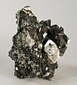
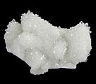
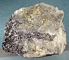
Minerals Found in Ouray County
-
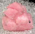
Rhodochrosite—Monarch Mountain Mine, Ouray District
-
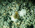
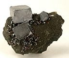
Sphalerite-Chalcopyrite-Quartz--Camp Bird Mine, Ouray
-
Sphalerite—Camp Bird Mine, Ouray
-
Quartz-Baryte—Silver Point Mine, Ouray County
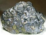
-
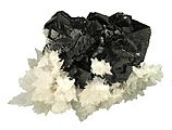
Galena—Camp Bird Mine, Ouray
-
Galena-Sphalerite—Camp Bird Mine, Ouray
-
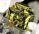
Chalcopyrite-Quartz—Camp Bird Mine, Ouray
-
- Molybdenite-Pyrite—Ouray County
-
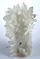
Quartz—Crystal Cave, Ouray
-
Gold—Ouray


Images for kids
-
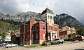
Ouray County Courthouse
-
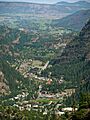
View from Ouray to Loghill Village
-
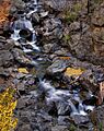
Fall colors on Bear Creek, south of Ouray


See also
 In Spanish: Condado de Ouray para niños
