
San Juan Mountains facts for kids
Quick facts for kids San Juan Mountains |
|
|---|---|

|
|
| Highest point | |
| Peak | Uncompahgre Peak |
| Elevation | 14,309 ft (4,361 m) |
| Geography | |
| Country | United States |
| State | Colorado, New Mexico |
| Parent range | Rocky Mountains |

The San Juan Mountains are a tall and rugged mountain range. You can find them in the Rocky Mountains in southwestern Colorado and northwestern New Mexico. This area is famous for its rich minerals, especially gold and silver. Because of this, it was a very important place for mining in early Colorado.
Many towns in the San Juan Mountains, like Creede, Lake City, Silverton, Ouray, and Telluride, started as old mining camps. While big mining operations have mostly stopped, some people still search for minerals. The last large mines, like the Sunnyside Mine and the Idarado Mine, closed down in the late 1900s.
The San Juan Mountains are also known for their many old volcanoes. One of these, La Garita Caldera, is huge, about 35 miles (56 km) wide! You can see large areas of hardened lava rock, especially on the eastern side of the mountains.
Contents
Fun Things to Do in the San Juan Mountains
.jpg)
Today, tourism is a big part of the economy here. Many people visit to enjoy the beautiful scenery and exciting activities.
- Ride the Train: A popular attraction is the narrow gauge railway between Durango and Silverton. It's a fun way to see the mountains in the summer.
- Go Jeeping: You can explore old trails that once connected mining camps, like the famous Black Bear Road, in a Jeep.
- Visit Ghost Towns: Exploring old ghost towns is a popular activity. Many old mining camps are now used as summer homes.
- Hiking and Climbing: The San Juans are great for wilderness trekking and mountain climbing.
- Skiing: Even though the mountains are very steep and get a lot of snow, only Telluride has become a major ski resort. Other ski areas include Purgatory Resort (near Durango) and Wolf Creek ski area on Wolf Creek Pass. There's also Silverton Mountain ski area for more adventurous skiing.
Rivers and Forests

The Rio Grande river flows from the east side of the San Juan Mountains. On the western side, rivers like the San Juan, Dolores, and Gunnison flow into the larger Colorado River.
A big part of the San Juan Mountains is covered by the San Juan and Uncompahgre National Forests. These are protected areas of nature. The Continental Divide Trail, a very long hiking path, follows the highest points of the San Juan Mountains. The Weminuche Wilderness, which is Colorado's largest wilderness area, is also found here. It covers a huge area of about 499,771 acres (202,250 hectares).
The San Juan Mountains are special because they have many high plateaus and peaks. This means that towns and cities in the region are some of the highest in the country. For example, Telluride Airport is the highest airport in the United States that has regular flights, sitting at 9,070 feet (2,765 meters) above sea level.
Tallest Peaks in the San Juans

The San Juan Mountains are home to many very tall peaks. Here are some of the most famous ones:
- Uncompahgre Peak is the tallest mountain in the San Juans.
- Mount Wilson
- Mount Sneffels
- Mount Eolus
- Handies Peak
- San Luis Peak
- Vermilion Peak
- Rio Grande Pyramid
- Mount Oso
- Tower Mountain
- Sultan Mountain
- Summit Peak
- Dolores Peak
- Lavender Peak
- Bennett Peak
- Conejos Peak
- Twilight Peak
- South River Peak
- Peak 13,010
- Lone Cone
- Graham Peak
- Elliott Mountain
- Cornwall Mountain
- Sawtooth Mountain
- Chalk Benchmark
- Little Cone
- Cochetopa Dome
- Horse Mountain
There are dozens more peaks over 12,000 feet (3,658 meters) tall in this range!
History of Mining and Workers

In the early 1900s, mining was a huge industry in the San Juan Mountains. In 1903, the mine owners in the area formed a group called the San Juan District Mining Association (SJDMA). This happened because the miners, through their union (the Western Federation of Miners), asked for an eight-hour workday. Most people in Colorado had voted to approve the eight-hour day.
However, the mine owners' association did not want to shorten work hours or increase wages. This disagreement led to a difficult strike between the miners and the mine owners.

Images for kids
-
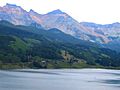
Trout Lake near Telluride
-
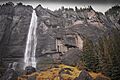
Bridal Veil Falls near Telluride
-
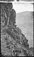
Hayden Geological Survey, 1870s


See also
 In Spanish: Montañas de San Juan para niños
