Conejos Peak facts for kids
Quick facts for kids Conejos Peak |
|
|---|---|

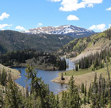
The peak viewed from a point above Mix Lake
|
|
| Highest point | |
| Elevation | 13,179 ft (4,017 m) |
| Prominence | 1,912 ft (583 m) |
| Isolation | 8.15 mi (13.12 km) |
| Listing |
|
| Geography | |
| Location | High point of Conejos County, Colorado, United States |
| Parent range | San Juan Mountains |
| Topo map | USGS 7.5' topographic map Platoro, Colorado |
| Climbing | |
| Easiest route | Hike |
Conejos Peak is a very tall and important mountain summit found in the southern San Juan Mountains. These mountains are part of the larger Rocky Mountains in North America. This amazing peak stands at 13,179-foot (4,017 m) (about 4,017 meters) high. It's often called a "thirteener" because its height is over 13,000 feet.
You can find Conejos Peak inside the South San Juan Wilderness area, which is part of the Rio Grande National Forest. It's located about 31.6 kilometers (or 19.6 miles) north-northwest of Cumbres Pass. This special mountain is also the highest point in Conejos County, Colorado, United States.
Contents
Exploring Conejos Peak's Location
Conejos Peak is a key part of the San Juan Mountains, a rugged and beautiful range in southwestern Colorado. These mountains are known for their stunning views and challenging terrain. The peak itself is in Conejos County, which is one of Colorado's 64 counties. Being the highest point in the county makes it a special landmark for the area.
What is a County High Point?
A "county high point" is simply the highest natural elevation within a specific county. For Conejos County, that's Conejos Peak! Many hikers and climbers enjoy trying to reach the highest points in different counties or states as a fun challenge.
The South San Juan Wilderness
Conejos Peak is located within the South San Juan Wilderness. A wilderness area is a protected natural space where human activity is limited to preserve its wild character. This means you won't find many roads or buildings here, just nature. It's a great place for hiking, camping, and enjoying the outdoors, but visitors must follow special rules to protect the environment.
Rio Grande National Forest
The South San Juan Wilderness is part of the larger Rio Grande National Forest. National Forests are managed by the U.S. government for many uses, including recreation, wildlife protection, and timber. They offer many opportunities for people to connect with nature.
How to Reach the Summit
The easiest way to reach the summit of Conejos Peak is by hiking. While it's a tall mountain, it doesn't require technical climbing skills like ropes or special gear. However, hiking a "thirteener" still requires good physical fitness, proper gear, and careful planning. Hikers should always be prepared for changing weather conditions and high altitudes.
Preparing for a Mountain Hike
When planning to hike a mountain like Conejos Peak, it's important to:
- Carry enough water and snacks.
- Wear appropriate clothing layers for different temperatures.
- Have a map and compass or a GPS device.
- Tell someone your plans before you go.
- Be aware of the weather forecast.
- Know the signs of altitude sickness and how to prevent it.
See also

- In Spanish: Pico Conejos para niños
 | Frances Mary Albrier |
 | Whitney Young |
 | Muhammad Ali |


