
Dolores River facts for kids
Quick facts for kids Dolores River |
|
|---|---|
.jpg)
Dolores River
|
|

The Dolores River watershed
|
|
| Country | United States |
| State | Colorado, Utah |
| Physical characteristics | |
| Main source | San Juan National Forest Montezuma County, Colorado 11,650 ft (3,550 m) 37°43′18″N 107°52′47″W / 37.72167°N 107.87972°W |
| River mouth | Colorado River Grand County, Utah 4,390 ft (1,340 m) 38°49′00″N 109°16′02″W / 38.81667°N 109.26722°W |
| Length | 241 mi (388 km) |
| Basin features | |
| Basin size | 4,574 sq mi (11,850 km2) |
| Tributaries | |
The Dolores River is a river in the western United States. It flows for about 241 miles (388 km) through the states of Colorado and Utah. This river is a major branch of the Colorado River.
The Dolores River flows through a dry, rugged area called the Colorado Plateau. This region is located west of the San Juan Mountains. The river's name comes from Spanish words meaning "River of Our Lady of Sorrows." An explorer named Juan Maria Antonio Rivera may have named it in 1765.
Before dams were built, the river's average flow was about 1,200 cubic feet per second. Now, due to water being used for other things, it flows at about 600 cubic feet per second.
Contents
Where the River Flows

The Dolores River begins high in the San Juan Mountains of Colorado. It starts in a meadow called Tin Can Basin, near Hermosa Peak. This area is about 5 miles (8 km) south of Lizard Head Pass.
The river flows southwest through a canyon past the town of Rico. It then meets the West Dolores River. After this, it flows into McPhee Reservoir near Dolores. This reservoir is about 10 miles (16 km) long. It holds water from the upper Dolores River for irrigation, which means watering crops.
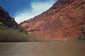
Below McPhee Dam, the river enters the Dolores County again. Here, it carves out the amazing Dolores River Canyon. This canyon is over 40 miles (64 km) long and about 1,100 feet (335 meters) deep. The canyon is famous for its visible rock layers and desert animals. When there's a lot of snowmelt, this part of the river is great for whitewater rafting.
The river then crosses into San Miguel County and later Montrose County. It cuts through a unique area called the Paradox Valley. This valley runs in an unusual direction compared to the river. Just after Paradox Valley, the Dolores River is joined by the San Miguel River. The San Miguel River is often as big or even bigger than the Dolores, especially in dry years.
After joining the San Miguel, the Dolores River flows into Mesa County. It passes Gateway and then turns west into Utah. The last part of the river, in Grand County, joins the Colorado River near the old Dewey Bridge. This is about 30 miles (48 km) upstream from Moab.
River Flow and Changes
The amount of water flowing in the Dolores River has changed over time. Before McPhee Dam was built in 1986, the river's average flow near Cisco, Utah was about 1,160 cubic feet per second. After the dam was completed, the average flow dropped to about 599 cubic feet per second.
This drop in flow is even clearer upstream at Bedrock, Colorado. Before the dam, the average flow was about 504 cubic feet per second. After the dam, it went down to about 240 cubic feet per second. This shows how much water is now used for irrigation.
How the River Was Formed
Scientists believe the Dolores River used to flow south. It likely joined the San Juan River near the Four Corners area. However, about 70 million years ago, a mountain called Sleeping Ute Mountain rose up. This event changed the river's path, making it flow north towards the Colorado River. This is how the Dolores River Canyon was formed. It also created unique features like the Paradox Valley.
The canyon walls show rocks that are millions of years old. Some are 300-million-year-old limestone, and others are 140-million-year-old sandstone.
Some geologists think the lower Dolores River might have been the original path of the Colorado River. The Colorado River now flows through the Grand Valley and Westwater Canyon. However, other scientists disagree. They think the canyon might have been formed by glaciers long ago.
River Modifications and Dams

The Dolores River has a large dam called McPhee Reservoir. It is located near Cortez, Colorado. The dam's main purpose is to provide water for irrigation. It waters about 61,660 acres (24,953 hectares) of dry land. The U.S. Bureau of Reclamation manages this dam and its canals.
In some years, almost all the water that flows into the reservoir is used for irrigation. This leaves only a small amount of water to flow downstream. This means the 150-mile (242 km) section of the river below the dam can become very small, almost like a creek.
The dam helps farmers by letting them water their crops longer into the year. Before the dam, the river's natural flow would be too low by July or August. While the dam reduces the big spring floods, it does provide extra water in late summer (August to October). This helps keep fish alive in the river.
How water is released from McPhee Dam is a debated topic. Currently, the dam is filled first. Only when there's a lot of water, more than the reservoir can hold, are larger amounts released. This makes it hard for people who want to go rafting or kayaking to plan their trips. Groups like the San Juan Citizens' Alliance are working to find a better way to release water. They hope to allow for more planned releases that benefit both farmers and recreational users.
Fun on the River
The Dolores River is a great place for outdoor fun! You can go rafting and kayaking on parts of the river. The rapids can be up to Class IV, which means they are exciting but require skill.
However, the river is heavily used for irrigation. In years with low water, it might not be possible to boat at all. When there's a lot of snowmelt, the section from Bradfield Ranch to Slickrock, Colorado, is popular. It offers beautiful views, places to camp, and fun rapids.
The Bureau of Land Management (BLM) suggests certain water levels for different boats. For canoes, kayaks, and inflatable kayaks, you need at least 200 cubic feet per second. For small rafts (up to 14 feet), 800 cubic feet per second is recommended. Larger rafts (up to 18 feet) need about 1,000 cubic feet per second.
You usually don't need a permit to boat in the Colorado section of the river. But if you want to boat from Gateway, Colorado, into Utah and to the Colorado River, you need a permit from the Moab BLM office. In 2010, floods changed some rapids, making them harder to navigate.
Images for kids
-
Diversion Dam Rapid in 2011 at 700 cfs
-
Historic hanging flume clings precariously to canyon walls
-
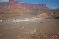
The Dolores river at low water, ~250 cfs


See also
 In Spanish: Río Dolores para niños
