
Moab, Utah facts for kids
Quick facts for kids
Moab
|
|
|---|---|
.jpg)
Downtown Moab, Utah
|
|

Location in Grand County and the state of Utah
|
|
| Country | United States of America |
| State | Utah |
| County | Grand |
| Settled | 1878 |
| Incorporated | 1902 |
| Named for | Moab |
| Government | |
| • Type | Mayor/city council |
| Area | |
| • Total | 4.80 sq mi (12.42 km2) |
| • Land | 4.80 sq mi (12.42 km2) |
| • Water | 0.00 sq mi (0.00 km2) |
| Elevation | 4,026 ft (1,227 m) |
| Population
(2020)
|
|
| • Total | 5,366 |
| • Density | 1,117.92/sq mi (432.05/km2) |
| Time zone | UTC-7 (Mountain (MST)) |
| • Summer (DST) | UTC-6 (MDT) |
| ZIP Code |
84532
|
| Area code(s) | 435 |
| FIPS code | 49-50700 |
| GNIS feature ID | 1430389 |
| U.S. Routes | |
Moab (![]() i/ˈmoʊ.æb/) is a city in eastern Utah, United States. It is the biggest city in Grand County and is famous for its amazing natural beauty. In 2020, about 5,366 people lived there.
i/ˈmoʊ.æb/) is a city in eastern Utah, United States. It is the biggest city in Grand County and is famous for its amazing natural beauty. In 2020, about 5,366 people lived there.
Lots of tourists visit Moab every year. They especially come to see the nearby Arches National Park and Canyonlands National Park. Moab is also a super popular spot for mountain bikers. They love riding the many trails, including the famous Slickrock Trail. People who enjoy off-roading also visit for the yearly Moab Jeep Safari.
Moab is home to one of the nine regional campuses of Utah State University.
Contents
Moab's History: From Trails to Tourism
Early Days and Name Origins
The name "Moab" comes from a biblical land east of the Jordan River. Some historians think the city's first postmaster, William Pierce, chose the name. He thought both places were "the far country." Others believe the name comes from the Paiute word "moapa," meaning "mosquito."
In the 1800s, the area around Moab was an important crossing point for the Colorado River. This was part of the Old Spanish Trail. In 1855, settlers from The Church of Jesus Christ of Latter-day Saints tried to build a trading fort here. It was called "Elk Mountain Mission." But after attacks from Native Americans, the fort was abandoned. New settlers came in 1878 and created a lasting community. Moab officially became a town on December 20, 1902.
In 1883, a main railroad line was built across eastern Utah. It did not go through Moab. Instead, it passed through towns like Thompson Springs and Cisco, about 40 miles (64 km) north. Later, new ways to cross the Colorado River were built, like Lee's Ferry and Navajo Bridge. These changes meant trade routes moved away from Moab. Farmers and merchants in Moab had to start shipping their goods to faraway markets. Even so, the bridge over the Colorado River at Moab was important enough to be guarded during World War II.
During World War II, a former camp near Moab was used for Japanese Americans. These were people who authorities felt were "troublemakers." This camp was called the Moab Isolation Center. It opened in January 1943. Many people sent there had resisted rules in other camps. The camp closed in April 1943, and most people were moved to a larger center. In 1994, the site was added to the National Register of Historic Places.
Later Years and Economic Changes
Moab's economy first relied on farming. Then, it shifted to mining. Uranium and vanadium were found in the area in the 1910s and 1920s. Later, potash, manganese, oil, and gas were discovered. In the 1950s, Moab became known as the "Uranium Capital of the World." This happened after geologist Charles Steen found a large uranium deposit. This discovery came when nuclear weapons and nuclear power were becoming important in the United States. Moab then had a big boom.
The city's population grew by almost 500% in a few years, reaching nearly 6,000 people. This growth led to a lot of new houses and schools being built. Charles Steen gave a lot of money and land to help build new homes and churches in Moab.
When the Cold War ended, Moab's uranium boom was over. The city's population then dropped a lot. By the early 1980s, many homes were empty, and most uranium mines had closed.
In 1949, Western movie director John Ford was convinced to film in the Moab area. He had been using Monument Valley for his movies for years. A local rancher, George White, showed Ford how beautiful Moab was. Since then, many movies have been filmed in the area. They use Arches National Park and Canyonlands National Park as amazing backdrops.
Since the 1970s, tourism has become very important to Moab's economy. Thanks to the John Ford movies and magazine articles, the area is popular. It attracts photographers, rafters, hikers, rock climbers, and especially mountain bikers. Moab is also a growing spot for four-wheelers, BASE jumpers, and highlining fans. About 16 miles (26 km) south of Moab is the Hole N' The Rock. This is a 5,000 square foot (460 m²) home carved into a rock wall. National Geographic called it one of the top 10 roadside attractions in the U.S. Moab's population grows in spring and summer. This is when many people come to work in outdoor recreation and tourism.
Recently, many people have bought second homes in Moab. The mild winters and pleasant summers attract them. This has caused some debate, similar to other resort towns in the American West. Property values and living costs are rising. This affects local workers with lower incomes.
Sunset Magazine listed Moab as one of the "20 best small towns in the West" in 2009. Other magazines have also praised it.
Since 2011, Moab has hosted an LGBT Pride festival. The first march had over 350 people. The second year, more than 600 people attended.
Cultural Events and Festivals
Moab hosts many cultural events and festivals. These include the Moab Music Festival, LGBT Pride Festival, Folk Festival, and Skinny Tire Festival.
- The annual Moab Music Festival happens in September. It was started in 1992 by musicians from New York.
- The Moab Folk Festival features concerts by many folk musicians every November.
- The LGBT Pride Festival has been held since 2011. It includes a "visibility" march.
- The Skinny Tire Festival is a road bike event each March. It raises money for cancer research and survivors.
- Moab also supports the Moab Art Walk. This event highlights local artists' work at different places throughout the year.
Geography and Climate
Moab's Location and Surroundings
Moab is located just south of the Colorado River. It sits at an elevation of about 4,025 feet (1,227 m) on the Colorado Plateau. It is 18 miles (29 km) west of the Utah/Colorado state line.
You can reach Moab via U.S. Route 191. It is 31 miles (50 km) south of Interstate 70 at Crescent Junction. It is also 54 miles (87 km) north of Monticello. The entrance to Arches National Park is only 4 miles (6.4 km) north of Moab on US 191. Kokopelli's Trail, a 142-mile (229 km) mountain biking trail, ends in Moab.
The United States Census Bureau says the city covers a total area of 4.8 square miles (12.4 km²). All of this area is land.
Moab's Weather
Moab has a semi-arid climate. This means it's mostly dry. It has hot summers and cold winters. Rain and snow are spread out evenly through the year, usually less than one inch (2.5 cm) per month.
On average, there are 41 days a year when temperatures reach 100°F (38°C) or higher. There are 109 days when it reaches 90°F (32°C) or higher. In winter, temperatures stay at or below freezing for about 3.6 days. The hottest temperature ever recorded was 114°F (46°C) on July 7, 1989. The coldest was -24°F (-31°C) on January 22, 1930.
Moab gets about 9.02 inches (229 mm) of precipitation each year. There are about 55 days with measurable rain or snow. The wettest year was 1983, with 16.42 inches (417 mm). The driest was 1898, with 4.32 inches (110 mm). The most rain in one month was 6.63 inches (168 mm) in July 1918. The most in 24 hours was 2.77 inches (70 mm) on July 23, 1983.
Average snowfall is about 6.9 inches (17.5 cm) per year. The most snow in one season was 74 inches (188 cm) during 1914–15. December is usually the snowiest month. The record for December was 46.0 inches (117 cm) in 1915.
| Climate data for Moab, Utah, 1991–2020 normals, extremes 1893–present | |||||||||||||
|---|---|---|---|---|---|---|---|---|---|---|---|---|---|
| Month | Jan | Feb | Mar | Apr | May | Jun | Jul | Aug | Sep | Oct | Nov | Dec | Year |
| Record high °F (°C) | 67 (19) |
78 (26) |
88 (31) |
96 (36) |
109 (43) |
113 (45) |
114 (46) |
110 (43) |
108 (42) |
97 (36) |
82 (28) |
67 (19) |
114 (46) |
| Mean maximum °F (°C) | 57.2 (14.0) |
65.4 (18.6) |
78.2 (25.7) |
86.2 (30.1) |
95.8 (35.4) |
104.1 (40.1) |
106.9 (41.6) |
103.7 (39.8) |
98.7 (37.1) |
88.4 (31.3) |
71.7 (22.1) |
58.1 (14.5) |
107.4 (41.9) |
| Mean daily maximum °F (°C) | 43.5 (6.4) |
52.1 (11.2) |
64.6 (18.1) |
72.4 (22.4) |
82.6 (28.1) |
93.9 (34.4) |
99.2 (37.3) |
95.9 (35.5) |
87.7 (30.9) |
73.5 (23.1) |
57.1 (13.9) |
43.9 (6.6) |
72.2 (22.3) |
| Daily mean °F (°C) | 32.4 (0.2) |
39.6 (4.2) |
50.1 (10.1) |
57.4 (14.1) |
66.7 (19.3) |
76.4 (24.7) |
82.7 (28.2) |
80.0 (26.7) |
71.2 (21.8) |
57.6 (14.2) |
43.7 (6.5) |
33.0 (0.6) |
57.6 (14.2) |
| Mean daily minimum °F (°C) | 21.4 (−5.9) |
27.2 (−2.7) |
35.6 (2.0) |
42.6 (5.9) |
50.7 (10.4) |
58.9 (14.9) |
66.3 (19.1) |
64.1 (17.8) |
54.7 (12.6) |
41.7 (5.4) |
30.3 (−0.9) |
22.0 (−5.6) |
43.0 (6.1) |
| Mean minimum °F (°C) | 10.0 (−12.2) |
15.6 (−9.1) |
23.1 (−4.9) |
29.9 (−1.2) |
38.1 (3.4) |
47.6 (8.7) |
56.4 (13.6) |
54.9 (12.7) |
41.5 (5.3) |
28.0 (−2.2) |
17.4 (−8.1) |
9.3 (−12.6) |
6.8 (−14.0) |
| Record low °F (°C) | −24 (−31) |
−13 (−25) |
8 (−13) |
15 (−9) |
27 (−3) |
36 (2) |
43 (6) |
40 (4) |
28 (−2) |
15 (−9) |
2 (−17) |
−19 (−28) |
−24 (−31) |
| Average precipitation inches (mm) | 0.65 (17) |
0.66 (17) |
0.70 (18) |
0.77 (20) |
0.82 (21) |
0.35 (8.9) |
0.92 (23) |
0.88 (22) |
0.89 (23) |
1.03 (26) |
0.70 (18) |
0.76 (19) |
9.13 (232.9) |
| Average snowfall inches (cm) | 1.7 (4.3) |
1.4 (3.6) |
0.2 (0.51) |
0.0 (0.0) |
0.0 (0.0) |
0.0 (0.0) |
0.0 (0.0) |
0.0 (0.0) |
0.0 (0.0) |
0.1 (0.25) |
1.0 (2.5) |
4.9 (12) |
9.3 (23.16) |
| Average precipitation days (≥ 0.01 in) | 5.4 | 6.2 | 5.5 | 5.4 | 4.8 | 2.5 | 4.7 | 6.4 | 5.4 | 5.4 | 4.4 | 5.5 | 61.6 |
| Average snowy days (≥ 0.1 in) | 1.2 | 0.7 | 0.2 | 0.0 | 0.0 | 0.0 | 0.0 | 0.0 | 0.0 | 0.1 | 0.4 | 2.1 | 4.7 |
| Source 1: NOAA | |||||||||||||
| Source 2: National Weather Service | |||||||||||||
Moab's Population and People
| Historical population | |||
|---|---|---|---|
| Census | Pop. | %± | |
| 1890 | 333 | — | |
| 1900 | 376 | 12.9% | |
| 1910 | 586 | 55.9% | |
| 1920 | 856 | 46.1% | |
| 1930 | 863 | 0.8% | |
| 1940 | 1,084 | 25.6% | |
| 1950 | 1,274 | 17.5% | |
| 1960 | 4,682 | 267.5% | |
| 1970 | 4,793 | 2.4% | |
| 1980 | 5,333 | 11.3% | |
| 1990 | 3,971 | −25.5% | |
| 2000 | 4,779 | 20.3% | |
| 2010 | 5,046 | 5.6% | |
| 2020 | 5,366 | 6.3% | |
| U.S. Decennial Census | |||
In 2000, Moab had 4,779 people living in 1,936 households. About 30.5% of households had children under 18. The average household had 2.43 people. The average family had 3.10 people.
The population was spread out by age:
- 27.6% were under 18 years old.
- 28.5% were between 25 and 44 years old.
- 13.6% were 65 years or older.
The average age was 36 years. For every 100 females, there were about 95 males.
The median income for a household was $32,620. For a family, it was $38,214. About 15.7% of the population lived below the poverty line. This included 19.1% of those under 18.
Education in Moab
Moab has several public schools for students:
- Helen M. Knight Elementary School (Grades K-6)
- Moab Charter School (Grades K-6)
- Margaret L. Hopkin Middle School (Grades 7-8)
- Grand County High School (Grades 9-12)
Moab is also home to a local campus of Utah State University.
Moab in Movies and Books
Movies Filmed in Moab
Many movies have been filmed in the beautiful Moab area. Some of these include:
- Wagon Master (1950)
- Rio Grande (1950)
- Indiana Jones and the Last Crusade (1989)
- John Carter (2012)
Books Set in Moab
Several books have stories that take place partly in Moab:
- Desert Solitaire (1968)
- The Scholar of Moab (2011)
- The Man Who Quit Money (2012)
Transportation in Moab

Before 1883, Moab was a key place to cross the Colorado River. A ferry service helped people cross until a permanent bridge was built in 1911. This bridge was replaced in 1955, and then again in 2010. The highway that uses this bridge is now U.S. Route 191.
Moab got freight train access in 1962. A special railroad line was built to serve the Cane Creek potash mine. Moab has never had regular passenger train service. However, a company called Rocky Mountaineer started a scenic passenger train service between Moab and Denver, Colorado, in 2021.
Bus service is available through Salt Lake Express. There are also local shuttle services that take people to Salt Lake City and Grand Junction, Colorado.
For air travel, you can use Canyonlands Field. It has daily flights to Denver International Airport through SkyWest Airlines/United Express.
Notable People from Moab
- Robert Fulghum, author
- Steven L. Peck, author and professor
- Suelo, a person who lives a very simple life
- Zane Taylor, former NFL football player for the New York Jets
Images for kids
-
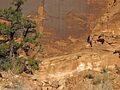
Native American Petroglyphs southwest of Moab
-
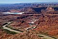
Potash mine and evaporation ponds (blue) near Moab, 2011. The water is dyed blue to speed evaporation.
-
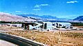
Charles Steen's Uranium Reduction Co. Mill, Moab, around the 1960s. It closed in 1984.
-
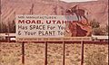
Sign promoting manufacturing in Moab during the early 1970s
-
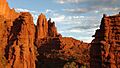
Fisher Towers at sunset


See also
 In Spanish: Moab (Utah) para niños
