
Monument Valley facts for kids
Quick facts for kids Monument Valley |
|
|---|---|
| Tsé Biiʼ Ndzisgaii | |
.jpg)
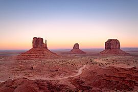
View of West Mitten Butte, East Mitten Butte, and Merrick Butte in northeastern Arizona
|
|
| Highest point | |
| Elevation | 5,000 to 6,000 ft (1,500 to 1,800 m) |
| Geography | |

Monument Valley
Location in Arizona

Monument Valley
Location in the United States
|
|
| Geology | |
| Mountain type | Butte |
| Type of rock | Siltstone |


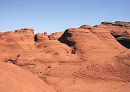
Monument Valley, known as Tsé Biiʼ Ndzisgaii by the Navajo people, which means "valley of the rocks," is a truly amazing place. It's located in the Colorado Plateau, mostly in northeastern Arizona and partly in Utah. This area is famous for its towering red sandstone rock formations called buttes. Some of these buttes reach over 300 meters (1,000 feet) high! The Navajo Nation, the Native American people who live here, consider this valley a very special and sacred place.
You might have seen Monument Valley before without even knowing it! Since the 1930s, this stunning landscape has appeared in many movies, TV shows, and even video games. Famous director John Ford used it as the backdrop for many of his Western films. Film critic Keith Phipps once said that this small area has shaped how people imagine the American West for decades.
Contents
Discovering Monument Valley: A Natural Wonder
Monument Valley is a special part of the Colorado Plateau, a huge area of high deserts and mountains. The valley floor sits very high, about 1,500 to 1,800 meters (5,000 to 6,000 feet) above sea level.
How Monument Valley Was Formed: Rocks and Colors
The ground in Monument Valley is mostly made of a type of rock called siltstone. This rock, along with sand, was laid down by ancient rivers that slowly carved out the valley over millions of years.
The amazing red color of the valley comes from iron oxide, which is like rust, found in the siltstone. You might also see some darker, blue-gray rocks. These get their color from another mineral called manganese oxide.
The tall buttes you see rising from the valley floor are like giant layered cakes. They have three main rock layers. The bottom layer is called the Organ Rock Shale. Above that is the de Chelly Sandstone, and on top is the Moenkopi Formation, often capped by Shinarump Conglomerate.
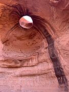
Some of the most famous rock formations have unique names, like the West and East Mitten Buttes (which look like giant mittens!), Merrick Butte, Elephant Butte, and Camel Butte. There's also the incredible Totem Pole, a very thin, tall rock that looks like it's reaching for the sky. You can even find large stone arches, like the "Eye of the Sun."
Visiting Monument Valley: What to See and Do

Monument Valley is home to the Monument Valley Navajo Tribal Park. This park is like a national park, but it's managed by the Navajo Nation. The nearby town of Oljato is also part of this beautiful region.
If you visit, you can pay a small fee to drive your car along a 27-kilometer (17-mile) dirt road through the park. This lets you see many of the famous rock formations up close. Some parts of Monument Valley, like Mystery Valley and Hunts Mesa, can only be explored with a special guided tour. These tours are a great way to learn more about the valley from local guides.
Weather in Monument Valley: Hot Summers, Cold Winters
Monument Valley has a desert climate. This means it has cold winters and very hot summers. Even though summers are hot, the high elevation of the valley helps to make the heat a bit more bearable.
On average, the temperature goes above 32°C (90°F) about 54 days each year. However, summer temperatures rarely go over 38°C (100°F). Summer nights are usually cool and pleasant, as temperatures drop quickly after the sun sets.
Winters are cold, but daytime temperatures are usually above freezing. It's rare for temperatures to fall below -18°C (0°F) in winter, but it can happen. Sometimes, Monument Valley gets a light snowfall in winter, but it usually melts away within a day or two.
| Climate data for Monument Valley, Arizona | |||||||||||||
|---|---|---|---|---|---|---|---|---|---|---|---|---|---|
| Month | Jan | Feb | Mar | Apr | May | Jun | Jul | Aug | Sep | Oct | Nov | Dec | Year |
| Record high °F (°C) | 60 (16) |
69 (21) |
77 (25) |
90 (32) |
99 (37) |
101 (38) |
107 (42) |
100 (38) |
97 (36) |
86 (30) |
73 (23) |
62 (17) |
107 (42) |
| Mean maximum °F (°C) | 52.07 (11.15) |
59.41 (15.23) |
70.37 (21.32) |
80.04 (26.69) |
88.27 (31.26) |
96.64 (35.91) |
99.44 (37.47) |
96.13 (35.63) |
90.48 (32.49) |
80.36 (26.87) |
65.18 (18.43) |
51.89 (11.05) |
100.17 (37.87) |
| Mean daily maximum °F (°C) | 40.6 (4.8) |
47.3 (8.5) |
58.2 (14.6) |
67.3 (19.6) |
77.6 (25.3) |
88.1 (31.2) |
92.0 (33.3) |
88.8 (31.6) |
80.6 (27.0) |
67.9 (19.9) |
51.5 (10.8) |
40.9 (4.9) |
66.7 (19.3) |
| Mean daily minimum °F (°C) | 24.3 (−4.3) |
28.2 (−2.1) |
35.5 (1.9) |
42.4 (5.8) |
52.3 (11.3) |
63.1 (17.3) |
67.0 (19.4) |
63.9 (17.7) |
57.3 (14.1) |
45.1 (7.3) |
32.9 (0.5) |
24.6 (−4.1) |
44.7 (7.1) |
| Mean minimum °F (°C) | 12.25 (−10.97) |
15.25 (−9.31) |
22.04 (−5.53) |
28.69 (−1.84) |
35.24 (1.80) |
47.08 (8.38) |
57.58 (14.21) |
54.73 (12.63) |
44.72 (7.07) |
32.61 (0.34) |
18.75 (−7.36) |
12.78 (−10.68) |
11.50 (−11.39) |
| Record low °F (°C) | −8 (−22) |
−4 (−20) |
9 (−13) |
15 (−9) |
20 (−7) |
31 (−1) |
49 (9) |
38 (3) |
33 (1) |
22 (−6) |
6 (−14) |
−9 (−23) |
−9 (−23) |
| Average precipitation inches (mm) | 0.26 (6.6) |
0.19 (4.8) |
0.19 (4.8) |
0.24 (6.1) |
0.30 (7.6) |
0.10 (2.5) |
0.54 (14) |
0.79 (20) |
0.73 (19) |
0.68 (17) |
0.32 (8.1) |
0.19 (4.8) |
4.54 (115) |
| Source: The Western Regional Climate Center | |||||||||||||
Monument Valley in Movies and Games

Monument Valley is famous for its appearances in many movies, TV shows, and even video games! It's been a popular filming location for a long time.
The legendary director John Ford loved to film his Western movies here. His films, like Stagecoach (from 1939) and The Searchers (from 1956), helped create the iconic image of the American West that many people still have today.
More recently, other movies have also used Monument Valley's amazing scenery. These include Sergio Leone's Once Upon a Time in the West (from 1968) and Gore Verbinski's The Lone Ranger (from 2013). It's truly a place that looks great on the big screen!
Gallery
-
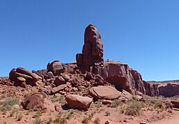
Monument Valley, the Thumb
-
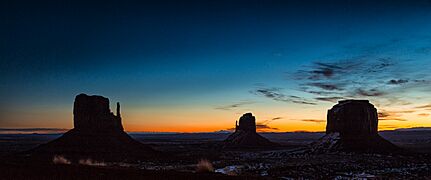
West, East Mittens and Merrick Butte after sunset
-
Snow-covered Monument Valley sunrise in January
-
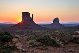
Monument Valley West and East Butte at 6:00 am
-
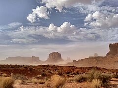
Sandstorm in Monument Valley
-
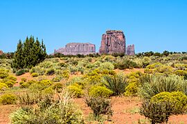
Vegetation of Monument Valley
-
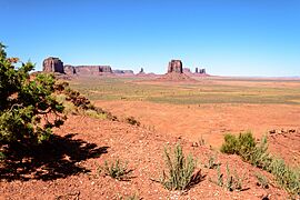
Monument Valley landscape
-
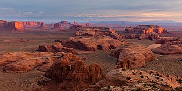
View on the Monument Valley from Hunts mesa
-
Monument Valley rock formation
-
Mystery Valley
.jpg)


.jpg)

.jpg)
Panorama


See also
 In Spanish: Valle de los Monumentos para niños
- List of sandstones
- Valley of the Gods
- Uluru
- Goulding's Lodge
- Tepui
- List of rock formations in Monument Valley
