
Cutler Formation facts for kids
Quick facts for kids Cutler FormationStratigraphic range: Early Permian |
|
|---|---|

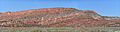
Cutler Formation near the type locality, Portland, Ouray County, Colorado
|
|
| Type | Geological formation |
| Sub-units | De Chelly Sandstone, White Rim Sandstone, Organ Rock Shale, Cedar Mesa Sandstone, Elephant Canyon Formation, Halgaito Shale |
| Underlies | Chinle Formation |
| Lithology | |
| Primary | Iron-rich arkose sandstone |
| Location | |
| Coordinates | 38°05′46″N 107°42′07″W / 38.096°N 107.702°W |
| Approximate paleocoordinates | 0°42′N 36°06′W / 0.7°N 36.1°W |
| Region | Colorado Plateau |
| Country | United States |
| Extent | Arizona Colorado New Mexico Utah |
| Type section | |
| Named for | Cutler Creek, north of Ouray, Co |
| Named by | Cross & Howe |
| Year defined | 1905 |
The Cutler Formation (also known as the Cutler Group) is a huge collection of rocks found in the southwestern United States. You can see it in Arizona, northwest New Mexico, southeast Utah, and southwest Colorado. These rocks formed a very long time ago, during the Permian period. This was specifically in the Early Permian, a time called the Wolfcampian stage.
The Cutler Formation is made up of smaller rock layers. Scientists call these layers either 'formations' or 'members'. Here are the main layers, listed from the youngest to the oldest:
- De Chelly Sandstone (found in Arizona, Colorado, New Mexico, Utah)
- White Rim Sandstone (found in Utah)
- Organ Rock Shale (found in Arizona, Colorado, New Mexico, Utah)
- Cedar Mesa Sandstone (found in Arizona, Utah)
- Elephant Canyon Formation (found in Utah)
- Halgaito Shale (the oldest layer, found in Arizona, Colorado, New Mexico, Utah)
Where Can You Find the Cutler Formation?
Scientists don't have one specific spot that is the "official" starting point for studying the Cutler Formation. It was first named by two scientists, Cross and Howe, in 1905. They named it after Cutler Creek, a stream near Ouray, Colorado.
Later, in 1929, Baker and Reeside looked closer at Cross and Howe's work. They divided the Cutler Formation into several parts. These parts included the Halgaito Tongue, the Cedar Mesa Sandstone Member, the Organ Rock Tongue, and the White Rim Sandstone Member.
In 1946, Wood and Northrop mapped out how far the Cutler Formation spreads. Then, in 1958, Wengerd and Matheny decided that the Cutler was so big and important that it should be called a "group" instead of just a "formation." A group is a larger collection of rock formations.
-
The Cutler Formation and Chinle Formation in Lisbon Valley, San Juan County, Utah
-

The Cedar Mesa Sandstone sitting on top of the Organ Rock Shale in Canyonlands, Utah

What is the Cutler Formation Made Of?
The Cutler Formation is mostly made of a type of rock called arkose sandstone. This sandstone is rich in iron, which often gives it a reddish color. These rocks tell us about ancient environments. They formed from sediments laid down by rivers (fluvial deposits) and in lakes (lacustrine deposits).
Where Does the Cutler Formation Appear?
You can see the Cutler Formation in many different geological areas. These areas are located across Arizona, Colorado, New Mexico, and Utah.
- Black Mesa Basin
- Paradox Basin
- Piceance Basin
- San Juan Mountains province
- San Juan Basin
- Uinta Basin
