
Ouray, Colorado facts for kids
Quick facts for kids
Ouray, Colorado
|
|
|---|---|

Ouray looking north from Highway 550
|
|
| Nickname(s):
Switzerland of America
|
|

Location of the City of Ouray in Ouray County, Colorado.
|
|

Ouray, Colorado
Location in the United States

Ouray, Colorado
Location in Colorado
|
|
| Country | United States |
| State | Colorado |
| County | Ouray County |
| City | Ouray |
| Incorporated | March 24, 1884 |
| Government | |
| • Type | Home rule municipality |
| Area | |
| • Total | 0.86 sq mi (2.23 km2) |
| • Land | 0.86 sq mi (2.23 km2) |
| • Water | 0.00 sq mi (0.00 km2) |
| Elevation | 7,687 ft (2,343 m) |
| Population
(2020)
|
|
| • Total | 898 |
| • Density | 1,044/sq mi (402.7/km2) |
| Time zone | UTC−07:00 (Mountain (MST)) |
| • Summer (DST) | UTC−06:00 (MDT) |
| ZIP Code |
81427 (PO Box)
|
| Area code(s) | 970 |
| FIPS code | 08-56420 |
| GNIS feature ID | 2411342 |
| Website | www.ci.ouray.co.us City of Ouray |
Ouray (/ˈjʊəreɪ/ YOOR-ay) is a town in Colorado, United States. It is the main town, or county seat, of Ouray County, Colorado. In 2020, about 898 people lived there.
Ouray is located high in the mountains, at an elevation of 7,792 feet (2,375 m). Its beautiful natural setting has earned it the nickname "Switzerland of America."
Ouray's Early Days and Growth

Ouray was started by miners. They came looking for silver and gold in the surrounding mountains. In 1875, people called prospectors (people who search for minerals) arrived in the area.
In 1877, William Weston and George Barber found important gold veins. Later, Thomas Walsh bought these areas. He opened the Camp Bird Mine in 1897. This mine produced a lot of gold. By 1902, it had produced almost 200,000 ounces of gold. By 1916, it had produced over one million ounces!
At its busiest time, Ouray had more than 30 active mines. The town was officially formed on October 2, 1876. It was named after Chief Ouray of the Utes, a Native American tribe. By 1877, Ouray had grown to over 1,000 people. It became the county seat of the new Ouray County on March 8, 1877.
Railroad and Modern Times

The Denver & Rio Grande Railway reached Ouray on December 21, 1887. This train service continued for many years. However, as more people started using cars and trucks, fewer people rode the train. The last regular passenger train left on September 14, 1930. The train line to Ouray was closed on March 21, 1953.
In 1986, Bill Fries, also known as the musician C. W. McCall, was elected mayor of Ouray. He served for six years.
Today, Ouray's Main Street is a special Historic District. Most of its buildings are from the late 1800s. Important buildings like the Beaumont Hotel and the Ouray City Hall and Walsh Library are listed on the National Register of Historic Places. Other historic places include the Ouray County Courthouse and the St. Elmo Hotel.
Ouray's Location and Landscape

Ouray is located in the San Juan Mountains in southwestern Colorado. It is about 40 miles (64 km) south of Montrose. Even though it's only about 10 miles (16 km) from Telluride, the mountain roads make the drive about 50 miles (80 km).
Ouray is connected to Silverton and Durango to the south by Red Mountain Pass. This pass goes over 11,000 feet (3,400 m) high. The road along the Uncompahgre River and over the pass is called the "Million Dollar Highway." The exact reason for this name is not fully known.
According to the United States Census Bureau, Ouray covers an area of about 0.8 square miles (2.1 km2). All of this area is land.
Ouray's Mountain Climate
Ouray is at an elevation of 7,792 feet (2,375 m). It has four clear seasons. Summers are warm during the day and cool at night. Brief thunderstorms often happen in July and August. These can bring heavy, but short, rain.
Autumns are cool and mostly clear, with some rain. Winters are long and cold, but usually not extremely cold. There is a lot of snow. Spring is generally cool, and sometimes the biggest snowfalls happen in early spring. Late spring into early summer (mid-May to late June) is mild to warm and usually the driest time of year. Ouray's climate type is called Dfb (Humid continental climate).
| Climate data for Ouray, Colorado, 1991–2020 normals, extremes 2000–present | |||||||||||||
|---|---|---|---|---|---|---|---|---|---|---|---|---|---|
| Month | Jan | Feb | Mar | Apr | May | Jun | Jul | Aug | Sep | Oct | Nov | Dec | Year |
| Record high °F (°C) | 57 (14) |
61 (16) |
70 (21) |
75 (24) |
88 (31) |
93 (34) |
94 (34) |
89 (32) |
88 (31) |
80 (27) |
70 (21) |
61 (16) |
94 (34) |
| Mean maximum °F (°C) | 49.0 (9.4) |
52.4 (11.3) |
62.5 (16.9) |
69.8 (21.0) |
76.2 (24.6) |
87.7 (30.9) |
88.7 (31.5) |
84.7 (29.3) |
80.8 (27.1) |
72.3 (22.4) |
62.0 (16.7) |
51.3 (10.7) |
89.8 (32.1) |
| Mean daily maximum °F (°C) | 34.4 (1.3) |
36.5 (2.5) |
44.5 (6.9) |
52.2 (11.2) |
63.4 (17.4) |
73.7 (23.2) |
79.1 (26.2) |
75.0 (23.9) |
68.9 (20.5) |
57.4 (14.1) |
44.2 (6.8) |
34.9 (1.6) |
55.4 (13.0) |
| Daily mean °F (°C) | 24.7 (−4.1) |
27.5 (−2.5) |
34.5 (1.4) |
41.5 (5.3) |
51.2 (10.7) |
60.1 (15.6) |
65.9 (18.8) |
63.1 (17.3) |
56.8 (13.8) |
45.6 (7.6) |
34.0 (1.1) |
25.2 (−3.8) |
44.2 (6.8) |
| Mean daily minimum °F (°C) | 15.0 (−9.4) |
18.5 (−7.5) |
24.6 (−4.1) |
30.8 (−0.7) |
39.0 (3.9) |
46.5 (8.1) |
52.7 (11.5) |
51.2 (10.7) |
44.7 (7.1) |
33.8 (1.0) |
23.7 (−4.6) |
15.5 (−9.2) |
33.0 (0.6) |
| Mean minimum °F (°C) | 0.8 (−17.3) |
2.5 (−16.4) |
9.2 (−12.7) |
17.3 (−8.2) |
27.0 (−2.8) |
36.9 (2.7) |
47.0 (8.3) |
45.3 (7.4) |
33.6 (0.9) |
20.0 (−6.7) |
7.8 (−13.4) |
0.7 (−17.4) |
−3.7 (−19.8) |
| Record low °F (°C) | −11 (−24) |
−16 (−27) |
−5 (−21) |
11 (−12) |
17 (−8) |
30 (−1) |
40 (4) |
41 (5) |
27 (−3) |
2 (−17) |
−6 (−21) |
−7 (−22) |
−16 (−27) |
| Average precipitation inches (mm) | 1.89 (48) |
1.71 (43) |
2.38 (60) |
2.15 (55) |
1.77 (45) |
0.91 (23) |
2.41 (61) |
2.42 (61) |
2.39 (61) |
2.12 (54) |
1.92 (49) |
1.56 (40) |
23.63 (600) |
| Average snowfall inches (cm) | 22.4 (57) |
19.6 (50) |
23.8 (60) |
14.6 (37) |
3.6 (9.1) |
0.1 (0.25) |
0.0 (0.0) |
0.0 (0.0) |
0.5 (1.3) |
5.1 (13) |
20.2 (51) |
16.5 (42) |
126.4 (320.65) |
| Average extreme snow depth inches (cm) | 12.3 (31) |
12.9 (33) |
10.1 (26) |
6.5 (17) |
2.3 (5.8) |
0.1 (0.25) |
0.0 (0.0) |
0.0 (0.0) |
0.3 (0.76) |
3.0 (7.6) |
8.1 (21) |
10.0 (25) |
16.4 (42) |
| Average precipitation days (≥ 0.01 in) | 8.0 | 7.9 | 9.3 | 9.8 | 7.1 | 5.5 | 9.6 | 14.6 | 11.0 | 7.7 | 8.4 | 7.2 | 106.1 |
| Average snowy days (≥ 0.1 in) | 7.7 | 7.1 | 8.6 | 5.9 | 1.5 | 0.1 | 0.0 | 0.0 | 0.3 | 2.3 | 6.6 | 6.3 | 46.4 |
| Source 1: NOAA | |||||||||||||
| Source 2: National Weather Service (mean maxima and minima, snow depth 2000-2022) | |||||||||||||
Ouray's Economy and Activities

Most of Ouray's economy comes from tourism. Ouray calls itself the "Switzerland of America" because it sits at the end of a narrow valley. It is surrounded by steep mountains on three and a half sides.
Outdoor Adventures

Many visitors come to Ouray for outdoor activities. These include ice climbing, mountain biking, hiking, and off-roading in four-wheel drive (4WD) vehicles. These trips go deep into the San Juan Mountains. Ouray is also a popular spot for motorcyclists. It marks the start of the famous Million Dollar Highway.
The Million Dollar Highway connects Ouray to nearby towns like Silverton and Durango. It is known as one of Colorado's most beautiful roads. However, it can also be dangerous due to sharp turns, steep edges, and no guard rails. Famous spots nearby include Yankee Boy Basin and Engineer Mountain.
Ouray is very popular for ice climbing. It has the world's first ice climbing park. This park has many frozen waterfalls, from 80 to 200 feet (61 m) high. They are created along more than a mile of the Uncompahgre Gorge. Water is sprayed to form the ice. The Ouray Ice Park is free to use. It attracts climbers from all over the world. The yearly Ice Festival is a big event with contests and lessons. Ice climbing has helped Ouray's economy. Many hotels and restaurants now stay open in winter for climbers.
Hot Springs and Waterfalls

There are five developed hot springs in Ouray and nearby Ridgway. These include warm pools and vapor caves. The Ouray Hot Springs is the largest facility with many pools.
Many waterfalls can be seen along the road from Durango to Ouray. Within Ouray itself, there are two waterfalls that are easy to reach. Cascade Falls is a short, 1/4-mile hike from a parking lot. Box Canyon Falls is at the southwest edge of Ouray.
Mining History and the Camp Bird Mine
Ouray was originally a mining town. The biggest and most famous mine was the Camp Bird Mine. It was the second-largest gold mine in Colorado. Thomas Walsh started it in 1896.
Even though a permit was filed in 2007, the mine is still not active. During its time, from 1896 to 1990, the mine produced about 1.5 million troy ounces of gold. It also produced 4 million troy ounces of silver. In 1995, some of the old mining equipment was sold to a smaller mine in Mongolia. You can see the empty mine on the road leading to Yankee Boy Basin and Imogene Pass.
Ouray's Population
| Historical population | |||
|---|---|---|---|
| Census | Pop. | %± | |
| 1880 | 864 | — | |
| 1890 | 2,534 | 193.3% | |
| 1900 | 2,196 | −13.3% | |
| 1910 | 1,644 | −25.1% | |
| 1920 | 1,165 | −29.1% | |
| 1930 | 707 | −39.3% | |
| 1940 | 951 | 34.5% | |
| 1950 | 1,089 | 14.5% | |
| 1960 | 785 | −27.9% | |
| 1970 | 741 | −5.6% | |
| 1980 | 684 | −7.7% | |
| 1990 | 644 | −5.8% | |
| 2000 | 813 | 26.2% | |
| 2010 | 1,000 | 23.0% | |
| 2020 | 898 | −10.2% | |
| U.S. Decennial Census | |||

As of the census in 2010, there were 1,000 people living in Ouray. There were 457 households, which are groups of people living together. About 26.5% of these households had children under 18.
The population was spread out by age. About 21.7% of the people were under 18 years old. About 17.0% were 65 years or older. The average age in Ouray was 45.1 years.
Getting to Ouray

The closest airport with regular flights is Montrose Regional Airport. It is about 40 miles (64 km) north of Ouray.
US|550|state=CO is the only paved road that goes into or out of Ouray. U.S. 550 starts about 40 miles (64 km) north of Ouray in Montrose. It runs south through Durango, Colorado to Bernalillo, New Mexico. The part of U.S. 550 that goes south from Ouray to Silverton is known as the "Million Dollar Highway."
Images for kids
-
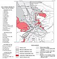
Ouray geologic map and location of historic mines
-
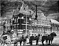
Stagecoach in front of the Beaumont Hotel, ca 1890
-
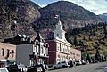
Ouray City Hall and fire station


See also
 In Spanish: Ouray para niños
