
Yeso Group facts for kids
Quick facts for kids Yeso GroupStratigraphic range: Kungurian |
|
|---|---|

Yeso Group at its type location northeast of Socorro, New Mexico, USA
|
|
| Type | Group |
| Sub-units | See text |
| Underlies | Glorieta Sandstone |
| Overlies | Abo Formation |
| Thickness | Up to 309 m (1,014 ft) |
| Lithology | |
| Primary | Sandstone |
| Other | Gypsum |
| Location | |
| Coordinates | 34°09′57″N 106°44′47″W / 34.1659°N 106.7465°W |
| Approximate paleocoordinates | 4°48′N 34°24′W / 4.8°N 34.4°W |
| Region | New Mexico |
| Country | United States |
| Type section | |
| Named for | Mesa del Yeso |
| Named by | W.T. Lee |
| Year defined | 1909 |
| Coordinates | 34°12′06″N 106°46′32″W / 34.2017512°N 106.7754422°W |
The Yeso Group is a collection of different rock layers found in New Mexico, USA. These rocks formed a very long time ago, during a period called the Permian Period, specifically in the Kungurian Age. Scientists can tell this by studying the fossils found within these rocks.
Contents
What is the Yeso Group?
The Yeso Group is made of many different kinds of rocks. These rocks show how the environment changed over time. In the past, this area had shallow seas, shorelines, and even sandy deserts.
You can see these rocks in the mountains and valleys around the Rio Grande Rift and in the Pecos River valley. They are also found deep underground in the Raton Basin. The rocks tell us that a large sea spread across the area from the south during the early Leonardian (Kungurian) Age.

Different Rock Layers
In the Jemez Mountains, the Yeso Group has two main parts:
- The lower part is called the De Chelly Sandstone. It has thick layers of sand that were likely deposited by wind, like sand dunes.
- The upper part is called the San Ysidro Formation. Its thinner layers suggest it formed in rivers.
The Yeso Group is very common in the Jemez Mountains. However, it disappears further north, showing where the ancient sand dunes ended.
Further south, the Yeso Group is divided into two other formations:
- The Arroyo de Alamillo Formation.
- The Los Vallos Formation.
As you go from north to south, the rocks change. In the north, they are mostly sand from wind-blown dunes. In the south, they become more like rocks formed in shallow seas, with lots of gypsum (a soft mineral) and carbonate rock (like limestone).
The Arroyo de Alamillo Formation has siltstone, ripple-marked sandstone, and some dolomitic limestone. This is different from the wind-blown sands of the De Chelly Formation. The Los Vallos Formation contains a mix of sandstone, siltstone, and gypsum. This is different from the thin sandstone layers of the San Ysidro Formation. The Los Vallos Formation itself has three smaller parts: the Torres, Cañas, and Joyita members.
The Yeso Group fits perfectly between the older Abo Formation below it and the younger Glorieta Sandstone above it.
Ancient Life: Fossils in the Yeso Group
The Yeso Group doesn't have a lot of fossils, but scientists have found some interesting things. They have discovered tiny marine fossils, like algae and small creatures called foraminiferans. They have also found trace fossils, which are signs of ancient life, like footprints of four-legged animals (tetrapods). Plant fossils have also been found.
In 2018, a very exciting discovery was made: a mold of an incomplete skeleton of an ancient reptile-like animal called a eupelycosaur was found in the lower layers of the Yeso Group. These tiny fossils help scientists figure out that the Yeso Group rocks are from the Kungurian Age.
Footprints of tetrapods have also been found in the De Chelly Sandstone. These footprints are not clear enough to identify the exact animal that made them.
Economic Uses of the Yeso Group
The Yeso Group has been important for producing carbon dioxide (CO2) from deep underground. From 1931 to 1980, not much CO2 was produced. But then, people needed more CO2 for something called "enhanced oil recovery," which helps get more oil out of the ground. So, pipelines were built to carry the CO2 to the Permian Basin.
By 2018, about 3.3 trillion cubic feet of CO2 had been produced. Scientists believe there are still 5 to 10 trillion cubic feet that can be recovered! Studies show that this CO2 comes from deep inside the Earth, from the mantle. The Yeso Group rocks simply act like a natural storage tank for the CO2. The CO2 collects in a part called the Tubb Sandstone Member and is trapped by another layer called the Cimarron Anhydrite Member.
How Scientists Studied the Yeso Group
The Yeso Group was first named in 1909 by a scientist named W.T. Lee. He named it after a small mesa called Mesa del Yeso, near Socorro, New Mexico. Over the years, other scientists studied these rocks and sometimes changed how they were grouped or named.
In 1946, Kelley and Wood divided the Yeso Formation into smaller parts. Later, in 2005, scientists Lucas and his team made big changes. They decided that the Yeso Formation was actually a "group" (a larger collection of formations) instead of just one formation. They also changed some of the names of its parts. These changes are still discussed by geologists today.
Images for kids
-
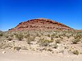
Yeso Group at its type location northeast of Socorro, New Mexico, USA
-
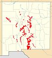
Map showing where the Yeso Formation is exposed in New Mexico

