
West and East Mitten Buttes facts for kids

Quick facts for kids West Mitten Butte |
|
|---|---|
| Highest point | |
| Elevation | 6,176 ft (1,882 m) NGVD 29 |
| Prominence | 856 ft (261 m) |
| Geography | |
| Location | Monument Valley, Arizona, U.S. |
| Topo map | USGS Mitten Buttes |
| East Mitten Butte | |
|---|---|
| Highest point | |
| Elevation | 6,226 ft (1,898 m) NGVD 29 |
| Prominence | 1,026 ft (313 m) |
| Geography | |
| Location | Monument Valley, Arizona, U.S. |
| Topo map | USGS Mitten Buttes |
The West and East Mitten Buttes, also known as the Mittens, are two amazing buttes. They are located in the Monument Valley Navajo Tribal Park. This park is in the northeast part of Navajo County, Arizona.
If you look at these buttes from the south, they look like two giant mittens. It's as if their thumbs are pointing towards each other. They are a famous sight in the desert landscape.
Contents
Discovering the Mitten Buttes
The Mittens are very close to the border between Arizona and Utah. They are only about 0.6 miles (1 kilometer) from the state line. West Mitten Butte is about 1.1 miles (1.8 kilometers) northeast of the park's main office.
How Tall Are the Mittens?
The top of West Mitten Butte reaches an elevation of 6,176 feet (1,882 meters). East Mitten Butte is a bit taller, with its summit at 6,226 feet (1,898 meters). These towering rock formations stand out in the flat desert.
The Mitten Buttes and Their Neighbors
The Mittens form a triangle with another cool rock formation called Merrick Butte. Merrick Butte is about 2/3 of a mile (1.1 kilometers) to the south. Together, they create a stunning view. There's also a larger flat-topped hill called Sentinel Mesa nearby.
What Are the Mittens Made Of?
These impressive buttes are made from three main layers of rock. Each layer tells a story about the Earth's past.
- The bottom layer is called Organ Rock Shale. This rock is often reddish-brown.
- The middle layer is de Chelly Sandstone. This type of sandstone is known for its beautiful colors.
- The top layer is the Moenkopi Formation. On top of this, there's a cap of rock called Shinarump Conglomerate. This hard cap protects the softer layers below from wearing away.
These different rock layers create the unique shapes and colors you see in the Mittens today.
Gallery
-
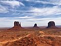
West Mitten Butte, East Mitten Butte and Merrick Butte
-
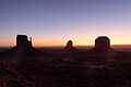
West Mitten Butte, East Mitten Butte and Merrick Butte before sunrise
-
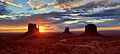
Sunrise by the Mitten Buttes
-
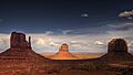
The Mittens and Merrick Butte (right foreground) form a triangle in Monument Valley.


