
Canyonlands National Park facts for kids

Canyonlands National Park is a special place in southeastern Utah, near the town of Moab. It's a huge park filled with colorful canyons, flat-topped mountains called mesas, and tall rock towers called buttes. These amazing shapes were carved by the mighty Colorado River and Green River, along with their smaller streams. President Lyndon Johnson officially made it a national park on September 12, 1964.
The park is split into four main areas: the Island in the Sky, the Needles, the Maze, and the rivers themselves (the Green and Colorado). Even though they are all desert areas, each part of Canyonlands has its own unique feel. A famous writer named Edward Abbey once called Canyonlands "the most weird, wonderful, magical place on earth."
Contents
History
In the early 1950s, Bates Wilson, who was in charge of Arches National Monument nearby, started exploring the lands south and west of Moab, Utah. He discovered the area now known as the Needles District. Wilson then began to suggest that this beautiful place should become a new national park.
As Wilson and others explored more, they wanted to include even more areas. These included where the Green and Colorado rivers meet (the Confluence), the Maze District, and Horseshoe Canyon.
In 1961, Secretary of the Interior Stewart Udall flew over the Confluence. He was amazed by the view! This made him very interested in Wilson's idea. Udall then started to push for Canyonlands National Park to be created.
Utah Senator Frank Moss introduced a bill to Congress to create the park. His plan tried to make both nature lovers and people who wanted to develop the land happy. Over the next four years, the idea was discussed, changed, and brought up many times.
Finally, in September 1964, President Lyndon B. Johnson signed the law that created Canyonlands National Park. Bates Wilson became the park's first superintendent. Many people call him the "Father of Canyonlands."
Recreation
Canyonlands is a very popular place for outdoor fun. Since 2007, over 400,000 people visit the park every year. In 2016, a record 776,218 people came!
The park's landscape is perfect for many activities. Hikers, mountain bikers, backpackers, and four-wheelers love exploring the park's tough and remote trails. The White Rim Road is a famous trail that goes between the rivers and the Island in the Sky. Since 2015, you need a special permit to drive or bike on the White Rim Road. This helps keep the wilderness feeling special for everyone.

The Island in the Sky district is the most visited part of the park. It's close to Moab, Utah and gets about 76% of all visitors. The Needles district is the second most popular, with about 20% of visitors. The Maze district is very remote and only gets about 1.5% of visitors. People who go rafting or kayaking on the rivers make up the rest.
People can float on the calm parts of the Green River and Colorado River before they meet. After the rivers join, Cataract Canyon has very powerful whitewater rapids. These are similar to the rapids in the Grand Canyon. When there's a lot of snowmelt, the rivers can create some of the biggest whitewater rapids in North America!
Geography

The Colorado River and Green River meet inside the park. They divide it into three main areas: the Island in the Sky, the Needles, and the Maze. The Colorado River then flows through Cataract Canyon.
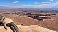
The Island in the Sky is a wide, flat-topped mountain (mesa) in the northern part of the park. It sits between the Colorado and Green rivers. From here, you can see amazing views of the White Rim, which is a sandstone ledge about 1,200 feet below. The rivers are another 1,000 feet below the White Rim!
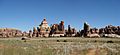
The Needles district is south of the Island in the Sky, on the east side of the Colorado River. It's named for its red and white striped rock towers. You can also find other cool rock formations here, like deep cracks called grabens, potholes, and arches. Unlike Arches National Park, many arches in the Needles are harder to reach. You often need long hikes or four-wheel drive trips to see them.
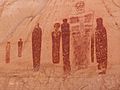
Long ago, the Ancestral Puebloans lived in this area. Some of their stone and mud homes are still well-preserved. These ancient people also made rock art called petroglyphs. A famous spot to see them is Newspaper Rock, along the road to the Needles.

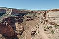
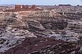
The Maze district is west of the Colorado and Green rivers. It's the hardest part of the park to get to. It's known as one of the most remote and difficult-to-reach places in the United States.
There's also a separate part of the park called Horseshoe Canyon. It's north of the Maze district. This canyon has ancient rock art made by hunter-gatherers from a very long time ago (2000-1000 BC). These paintings and murals are some of the oldest in America. Some images show horses, which were drawn after the Spanish brought horses back to America in 1540 AD.
Since the 1950s, scientists have been studying a special area of about 200 acres. It's completely surrounded by cliffs, so cattle have never grazed there. This area has about 62 acres of grassland. Scientists believe it might be the largest untouched grassland in the Four Corners region. This special area has been closed to the public since 1993 to keep it pristine.
Wildlife
Fauna

Many mammals live in Canyonlands National Park. You might see black bears, coyotes, skunks, bats, elks, foxes, bobcats, badgers, ring-tailed cats, pronghorns, desert bighorn sheep, and cougars. Visitors often spot Desert cottontails, kangaroo rats, and mule deer.
At least 273 different kinds of birds live in the park. You can find many types of hawks and eagles, like the red-tailed hawk and the golden eagle. Several kinds of owls also live here, including the great horned owl. Other birds include ravens, bluebirds, ducks, hummingbirds, and falcons.
The park is home to several reptiles. There are eleven kinds of lizards and eight kinds of snakes, including the midget faded rattlesnake.
Six types of amphibians have been found in the park. These include the red-spotted toad, Woodhouse's toad, and the northern leopard frog.
Flora

Canyonlands National Park has many different plants. You can find 11 types of cactus, 20 types of moss, and many wildflowers. Common trees include Utah juniper and pinyon pine. Shrubs like Mormon tea and blackbrush also grow here.
A very important part of the park's plant life is called cryptobiotic soil. This special soil helps plants grow by providing nutrients and moisture. It's very fragile, and just one footprint can destroy many years of its growth!
Climate
Canyonlands National Park has a dry, cold desert climate. This means it gets less than 10 inches of rain each year. Summers are very warm and mostly dry, while winters are cold and sometimes wet. Snowfall is usually light in winter.
In the Island in the Sky area, January temperatures usually range from a high of 37°F (3°C) to a low of 21°F (-6°C). July temperatures range from a high of 91°F (33°C) to a low of 66°F (19°C). It gets very hot, with about 43 days over 90°F (32°C) each year. The highest temperature ever recorded was 105°F (41°C).
In the Needles area, January temperatures usually range from a high of 41°F (5°C) to a low of 17°F (-8°C). July temperatures range from a high of 95°F (35°C) to a low of 62°F (17°C). It gets even hotter here, with about 75 days over 90°F (32°C) each year. The highest temperature ever recorded was 107°F (42°C).
| Climate data for Island in the Sky Visitor Center, elevation 5,666 ft (1,727 m), 1981-2010 normals, extremes 1981-2019 | |||||||||||||
|---|---|---|---|---|---|---|---|---|---|---|---|---|---|
| Month | Jan | Feb | Mar | Apr | May | Jun | Jul | Aug | Sep | Oct | Nov | Dec | Year |
| Record high °F (°C) | 58.6 (14.8) |
69.0 (20.6) |
79.8 (26.6) |
86.1 (30.1) |
98.5 (36.9) |
103.9 (39.9) |
106.4 (41.3) |
101.1 (38.4) |
97.9 (36.6) |
86.9 (30.5) |
71.0 (21.7) |
59.2 (15.1) |
106.4 (41.3) |
| Mean daily maximum °F (°C) | 38.1 (3.4) |
44.1 (6.7) |
54.9 (12.7) |
63.5 (17.5) |
74.2 (23.4) |
85.4 (29.7) |
91.7 (33.2) |
88.7 (31.5) |
79.5 (26.4) |
65.8 (18.8) |
49.7 (9.8) |
38.1 (3.4) |
64.6 (18.1) |
| Mean daily minimum °F (°C) | 20.8 (−6.2) |
25.8 (−3.4) |
33.3 (0.7) |
40.0 (4.4) |
49.5 (9.7) |
59.8 (15.4) |
66.0 (18.9) |
63.9 (17.7) |
54.9 (12.7) |
42.5 (5.8) |
31.1 (−0.5) |
21.3 (−5.9) |
42.5 (5.8) |
| Record low °F (°C) | −8.0 (−22.2) |
−12.4 (−24.7) |
10.4 (−12.0) |
16.3 (−8.7) |
26.0 (−3.3) |
28.7 (−1.8) |
46.0 (7.8) |
50.2 (10.1) |
27.6 (−2.4) |
9.2 (−12.7) |
6.2 (−14.3) |
−9.4 (−23.0) |
−12.4 (−24.7) |
| Average precipitation inches (mm) | 0.53 (13) |
0.50 (13) |
0.76 (19) |
0.72 (18) |
0.70 (18) |
0.45 (11) |
0.93 (24) |
1.04 (26) |
1.06 (27) |
1.30 (33) |
0.70 (18) |
0.58 (15) |
9.27 (235) |
| Average dew point °F (°C) | 18.6 (−7.4) |
21.8 (−5.7) |
23.3 (−4.8) |
25.7 (−3.5) |
29.5 (−1.4) |
32.7 (0.4) |
41.2 (5.1) |
45.1 (7.3) |
37.6 (3.1) |
29.5 (−1.4) |
23.2 (−4.9) |
17.9 (−7.8) |
28.9 (−1.7) |
| Source: PRISM | |||||||||||||
Geology

The amazing landscape of Canyonlands was formed over millions of years. Long, long ago, this area was a giant bowl where seawater collected. This water dried up, leaving behind thick layers of salt. Over time, these salt layers were buried under other rocks.
Later, the land was covered by warm, shallow seas again. This created layers of limestone and sandstone. Then, the seas went away, and the land was worn down by wind and water. This happened many times, creating different layers of rock.
Huge alluvial fans (fan-shaped deposits of sand and gravel) also filled the area. These became the red rocks you see today. Coastal sand dunes and sand bars also formed, which became the white cliffs like the White Rim Sandstone.
The climate changed a lot over time, from wet to very dry. During dry periods, huge deserts formed, leaving behind massive layers of sand that became rocks like the Navajo Sandstone.
About 70 million years ago, the Rocky Mountains began to rise. This also lifted the Canyonlands area. As the land rose, the Colorado River and other streams started to cut deep canyons. When the river reached the ancient salt layers, it caused the rocks above to crack and sink, forming features like The Grabens. During the ice ages, more rain and melting ice sped up the carving of the canyons. These processes are still happening today, but much slower.
Gallery
-
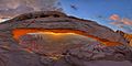
Mesa Arch at sunrise, Island in the Sky district
-
The White Rim Sandstone
-
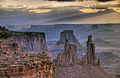
Canyonlands at daybreak. Washer Woman and Monster Tower in foreground, Airport Tower behind. La Sal Mountains in background
-
False Kiva stone circle
-
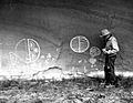
Petroglyphs, Horse Canyon, The Maze. 1962 photo
-
The Great Gallery, Horseshoe Canyon
-
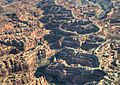
Aerial view of the Maze
-
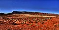
The White Rim in Canyonlands National Park
-
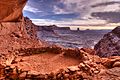
The view from the Island In The Sky overlooking the Colorado River
-
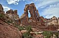
Druid Arch in the Needles district
-
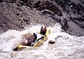
Raft in the Big Drop Rapids, Cataract Canyon
-
A view from Grand View Point Overlook toward Monument Basin
-
Shafer Canyon and Trail
-
The Molar and Angel Arch


.jpg)


.jpg)


Images for kids
-
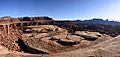
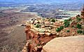
Chesler Park in the Needles
-
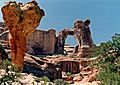
The Chocolate Drops buttes in the Maze district
.jpg)
.jpg)
See also
 In Spanish: Parque nacional Tierra de Cañones para niños
