
Arches National Park facts for kids
Quick facts for kids Arches National Park |
|
|---|---|
|
IUCN Category II (National Park)
|
|
| Location | Grand County, Utah, US |
| Nearest city | Moab, Utah |
| Area | 76,679 acres (119.811 sq mi; 31,031 ha; 310.31 km2) |
| Established | April 12, 1929, as a national monument; November 12, 1971, as a national park |
| Visitors | 1,460,652 (in 2022) |
| Governing body | National Park Service |
Arches National Park is a special place in eastern Utah, USA. It's right next to the Colorado River, about 4 miles (6.4 km) north of Moab, Utah. This park is famous for having over 2,000 natural sandstone arches, like the amazing Delicate Arch. It has more natural arches than anywhere else in the world! You'll also find many other cool rock shapes and formations here.
All these amazing shapes, like arches, tall spires, balanced rocks, and thin rock walls, were formed because the park sits on top of a huge underground salt bed. The park covers about 120 square miles (310 square kilometers) of high desert land on the Colorado Plateau. The highest point is Elephant Butte, at 5,653 feet (1,723 meters) high. The lowest point is 4,085 feet (1,245 meters) at the visitor center. It's a very dry place, getting less than 10 inches (25 cm) of rain each year.
The National Park Service takes care of Arches. It became a national monument on April 12, 1929, and then a full national park on November 12, 1971. In 2021, over 1.8 million people visited the park. By 2024, about 1.5 million people came to see its wonders.
Contents
Why Arches National Park is Special
The main goal of Arches National Park is to protect its amazing rock formations. This includes the arches, natural bridges, windows, tall spires, and balanced rocks. It also protects other interesting geological, historical, and scientific features. The park wants everyone to have a chance to enjoy these incredible natural sights.
How the Rocks Were Formed

The national park sits on top of a huge underground salt bed. This salt bed formed about 300 million years ago. This happened when an ancient sea covered the area and then dried up. Over millions of years, dirt and rocks piled up on top of this salt bed.
Later, about 200 million years ago, this area became a desert. Huge layers of sand, called Navajo Sandstone, were laid down. Then, about 140 million years ago, more sand and mud, called Entrada Sandstone, covered the Navajo layers. Much of the rock that piled up later has worn away. Most of the arches you see today are made from the Entrada Sandstone.
The heavy rock layers pushed down on the soft salt bed. This caused the salt to move and push up the rock layers above it, creating domes and long ridges. Sometimes, the ground cracked, and huge blocks of rock dropped down. The Moab Fault, a big crack in the earth, shows how much the land moved here.
As the salt moved and the land changed, wind and water slowly wore away the softer rock layers. Today, you mostly see the salmon-colored Entrada Sandstone (where most arches are) and the lighter Navajo Sandstone. These layers look like a giant cake! Over time, water got into cracks in the rocks. When water froze, it expanded, pushing the rocks apart. Wind then blew away the loose bits. This left behind tall, thin walls of rock called 'fins'. Wind and water kept working on these fins. Eventually, some parts of the fins crumbled away, creating holes. If the rock was just right, these holes grew into the famous arches we see today.
Even though the rocks look strong, the park's environment is very delicate. Over a million visitors each year can harm the fragile desert ecosystem. The soil has a special living crust made of tiny organisms like bacteria, algae, and fungi. This crust helps the soil stay together. Because the park is so dry, this soil crust is easily damaged by footsteps and takes a very long time to heal.
How Arches Form

.jpg)
Here's a simpler way to understand how the arches are made:
- Step 1: Salt Bed and Rock Layers About 300 million years ago, a huge salt bed formed underground. Over time, this salt bed was covered by layers of sand and mud, which turned into rock, especially the Entrada Sandstone.
- Step 2: Fins Appear The weight of the rock layers pushed on the salt bed, making it move. This caused the rock layers above to crack and lift, forming tall, thin walls of sandstone called fins.
- Step 3: Water Works Its Magic Rainwater, which is slightly acidic, seeped into cracks in these fins. This water slowly dissolved the natural "glue" (calcium carbonate) that held the sandstone together.
- Step 4: Gravity Helps As the glue dissolved, weaker parts of the rock crumbled away. Gravity then caused pieces of the stronger rock above to fall, creating openings.
- Step 5: Wind and Time Wind and more water continued to widen these openings, shaping them into the beautiful arches we see. This process is still happening today! Arches will continue to form, and old ones will eventually collapse.
Climate
Arches National Park has a cold semi-arid climate. This means it's usually dry with hot summers and cold winters.
| Climate data for Arches National Park Headquarters, Utah, 1991–2020 normals, extremes 1980–present | |||||||||||||
|---|---|---|---|---|---|---|---|---|---|---|---|---|---|
| Month | Jan | Feb | Mar | Apr | May | Jun | Jul | Aug | Sep | Oct | Nov | Dec | Year |
| Record high °F (°C) | 63 (17) |
74 (23) |
87 (31) |
93 (34) |
105 (41) |
110 (43) |
116 (47) |
109 (43) |
105 (41) |
95 (35) |
79 (26) |
69 (21) |
116 (47) |
| Mean maximum °F (°C) | 54.8 (12.7) |
64.6 (18.1) |
77.2 (25.1) |
85.8 (29.9) |
95.0 (35.0) |
104.2 (40.1) |
107.3 (41.8) |
104.2 (40.1) |
99.0 (37.2) |
88.5 (31.4) |
70.7 (21.5) |
56.4 (13.6) |
108.0 (42.2) |
| Mean daily maximum °F (°C) | 41.5 (5.3) |
50.0 (10.0) |
62.1 (16.7) |
69.6 (20.9) |
80.1 (26.7) |
92.5 (33.6) |
98.7 (37.1) |
95.8 (35.4) |
87.1 (30.6) |
72.1 (22.3) |
55.9 (13.3) |
41.9 (5.5) |
70.6 (21.4) |
| Daily mean °F (°C) | 31.9 (−0.1) |
39.6 (4.2) |
49.5 (9.7) |
56.7 (13.7) |
66.6 (19.2) |
77.8 (25.4) |
84.5 (29.2) |
81.9 (27.7) |
72.7 (22.6) |
58.1 (14.5) |
44.3 (6.8) |
32.9 (0.5) |
58.0 (14.4) |
| Mean daily minimum °F (°C) | 22.3 (−5.4) |
29.1 (−1.6) |
36.9 (2.7) |
43.7 (6.5) |
53.0 (11.7) |
63.0 (17.2) |
70.3 (21.3) |
67.9 (19.9) |
58.3 (14.6) |
44.2 (6.8) |
32.6 (0.3) |
23.9 (−4.5) |
45.4 (7.4) |
| Mean minimum °F (°C) | 10.7 (−11.8) |
16.8 (−8.4) |
24.8 (−4.0) |
30.6 (−0.8) |
39.1 (3.9) |
49.1 (9.5) |
58.2 (14.6) |
57.8 (14.3) |
43.1 (6.2) |
29.1 (−1.6) |
18.8 (−7.3) |
10.7 (−11.8) |
7.4 (−13.7) |
| Record low °F (°C) | −4 (−20) |
−8 (−22) |
13 (−11) |
21 (−6) |
28 (−2) |
37 (3) |
50 (10) |
44 (7) |
26 (−3) |
16 (−9) |
10 (−12) |
−4 (−20) |
−8 (−22) |
| Average precipitation inches (mm) | 0.55 (14) |
0.56 (14) |
0.65 (17) |
0.71 (18) |
0.75 (19) |
0.43 (11) |
0.73 (19) |
0.90 (23) |
0.88 (22) |
1.12 (28) |
0.56 (14) |
0.61 (15) |
8.45 (215) |
| Average snowfall inches (cm) | 2.1 (5.3) |
1.2 (3.0) |
0.5 (1.3) |
0.0 (0.0) |
0.0 (0.0) |
0.0 (0.0) |
0.0 (0.0) |
0.0 (0.0) |
0.0 (0.0) |
0.1 (0.25) |
0.7 (1.8) |
3.5 (8.9) |
8.1 (21) |
| Average precipitation days (≥ 0.01 in) | 4.2 | 4.5 | 4.9 | 5.0 | 4.8 | 2.4 | 4.7 | 6.0 | 4.9 | 5.5 | 4.1 | 3.8 | 54.8 |
| Average snowy days (≥ 0.1 in) | 1.5 | 0.9 | 0.3 | 0.0 | 0.0 | 0.0 | 0.0 | 0.0 | 0.0 | 0.1 | 0.4 | 2.1 | 5.3 |
| Source: NOAA | |||||||||||||
| Mean daily daylight hours for Arches National Park | |||||||||||||
|---|---|---|---|---|---|---|---|---|---|---|---|---|---|
| Month | Jan | Feb | Mar | Apr | May | Jun | Jul | Aug | Sep | Oct | Nov | Dec | Year |
| Mean daily daylight hours | 10.0 | 10.5 | 12.0 | 13.0 | 14.0 | 15.0 | 14.5 | 13.5 | 12.5 | 11.5 | 10.0 | 9.5 | 12.2 |
| Source: Weather Atlas | |||||||||||||
Plants and Animals of Arches

Many animals live in Arches National Park. You might spot kangaroo rats, mule deers, desert bighorn sheep, and even cougars. Birds like scrub jays and peregrine falcons fly overhead. Look for common collared lizards and American Spadefoot Toads too.
The park is also home to many plants. You'll see prickly pear cactus, yucca plants, Utah juniper trees, and pinyon pines. Different grasses and desert flowers like evening primrose also grow here.
A special 'biological soil crust' covers much of the ground. It's made of tiny living things like bacteria, lichens, and mosses. This crust helps hold the soil together and soaks up water. It's very important for plants to grow in this dry environment.
History of the Park

People have lived in this area for about 10,000 years, since the last ice age. Ancient groups like the Fremont culture and Ancestral Puebloans lived here until about 700 years ago. Later, Ute people and Southern Paiute people called this land home. In 1775, Spanish missionaries visited. The first European-Americans tried to settle in 1855 but left soon after. By the late 1870s, ranchers and farmers settled nearby in Moab. Soon, people started talking about the amazing rock formations, seeing it as a place for visitors.
In 1923, a man named Frank A. Wadleigh from a railroad company visited the area. He was invited by Alexander Ringhoffer, who had found a beautiful spot he called 'Devils Garden'. Wadleigh was so impressed that he suggested to the National Park Service that this area should become a national monument. More people, like a geology student named Laurence Gould, also supported the idea.

After some studies and a bit of confusion about names, President Herbert Hoover officially made it the Arches National Monument in April 1929. The goal was to protect its unique arches and rock formations for science and education. The name 'Arches' was suggested by Frank Pinkely in 1925.
Later, in 1938, President Franklin D. Roosevelt made the monument bigger to protect more beautiful areas and help visitors. President Dwight Eisenhower made a small change in 1960 for a new road. In 1969, President Lyndon B. Johnson expanded the park even more. Then, in 1971, President Richard Nixon signed a law that changed its status from a national monument to a national park. Arches National Park was officially dedicated in May 1972.
Sadly, there have been times when people tried to damage the ancient petroglyphs (rock carvings) in the park. In 1980, experts used special laser technology to clean up damage. In 2016, another arch was damaged, but it was repaired using modern methods in 2018.
Fun Activities at Arches


To protect the delicate arches, climbing on any named or unnamed arch with an opening larger than 3 feet (1 meter) is not allowed. Other types of rock climbing are allowed in certain areas, but you need a permit. Activities like slacklining and BASE jumping are not allowed anywhere in the park.
You can enjoy many activities in Arches National Park:
- Driving Tours: Explore the park's scenic roads by car.
- Hiking: Walk along many trails to see the amazing formations up close.
- Bicycling: Ride your bike on designated roads.
- Camping: Stay overnight at the Devils Garden campground.
- Backpacking: Go on longer hikes and camp in the backcountry (permits needed).
- Canyoneering: Explore canyons, which might involve climbing and rappelling (permits needed).
- Rock Climbing: Climb on certain rock features (permits needed).
- Ranger Programs: Join park rangers for guided tours and talks.
- Stargazing: The park has very dark skies, making it a great place to see stars.
Arches in the Spotlight

Delicate Arch was featured on the third America the Beautiful Quarters coin in 2014. This coin honored national parks and historic sites. The Arches quarter was very popular, with over 465 million coins made.
A famous American writer named Edward Abbey worked as a park ranger at Arches in the 1950s. He wrote a book called Desert Solitaire about his experiences. His book, along with the park's beauty, has inspired many people to visit. They come for hiking, mountain bike riding, and off-pavement driving. The Hayduke Trail, a long 812-mile (1,307 km) backpacking route, even starts in the park!
Amazing Features to See
- Argon Tower – a 260-foot (79 m) tall pillar at Park Avenue.
- Balanced Rock – a huge rock balanced on a thin pedestal, as big as three school buses.
- Courthouse Towers – a group of tall stone columns.
- Dark Angel – a 150-foot (46 m) tall sandstone pillar at the end of the Devils Garden Trail.
- Delicate Arch – a famous arch that has become a symbol of Utah.
- Devils Garden – an area with many arches and columns along a ridge.
- Double Arch – two arches that meet at one end.
- Fiery Furnace – a maze-like area with narrow passages and tall rock columns.
- Landscape Arch – a very thin and long arch in the Devils Garden, with a span of 290 feet (88 m). It's the longest arch in the park!
- Marching Men – a collection of pillars that look like people marching.
- Petrified Dunes – ancient sand dunes that have turned into rock.
- Queen Nefertiti Rock – a rock formation at Park Avenue.
- Queen Victoria Rock – another formation at Park Avenue.
- Sheep Rock – a formation north of Park Avenue.
- The Organ – a large rock towering over the park road.
- Three Penguins – a formation near the park entrance.
- Tower of Babel – a formation towering over the park road.
- Wall Arch – this arch collapsed in August 2008.
- The Three Gossips – a group of sandstone towers in the Courthouse Towers area.
Images for kids
-
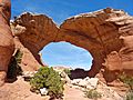
North Window
-
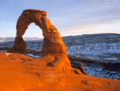
Delicate Arch: A vertical arch in the National Park
-
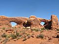
The Windows
-
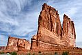
The Organ, a sandstone tower in the Courthouse Towers area
-
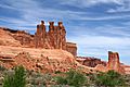
The Three Gossips
-
Broken Arch
-
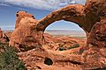
Double O Arch
-
Navajo Arch
-
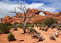
Skyline Arch
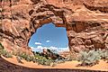
-
Partition Arch
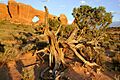
-
Pine Tree Arch
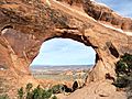
-
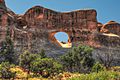
Tunnel Arch
-
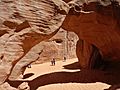
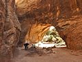
Sand Dune Arch
-
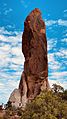
Dark Angel
-
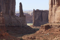
Park Avenue in Arches National Park


.jpg)


See also
 In Spanish: Parque nacional de los Arcos para niños
- List of national parks of the United States
- National Register of Historic Places listings in Arches National Park
- Natural Bridges National Monument - three natural bridges formed by flowing water
- Rainbow Bridge National Monument - the largest natural bridge in the Western Hemisphere
