Grand County, Utah facts for kids
Quick facts for kids
Grand County
|
||
|---|---|---|

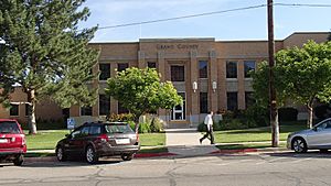
Grand County Courthouse, June 2014
|
||
|
||

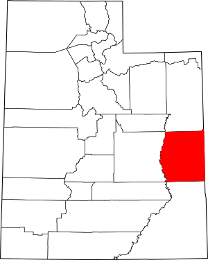
Location within the U.S. state of Utah
|
||
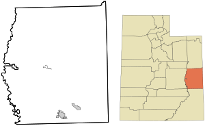
 Utah's location within the U.S. |
||
| Country | ||
| State | ||
| Founded | March 13, 1890 | |
| Named for | Grand River (now the Colorado River) | |
| Seat | Moab | |
| Largest city | Moab | |
| Area | ||
| • Total | 3,684 sq mi (9,540 km2) | |
| • Land | 3,672 sq mi (9,510 km2) | |
| • Water | 12 sq mi (30 km2) 0.3% | |
| Population
(2020)
|
||
| • Total | 9,669 | |
| • Estimate
(2023)
|
9,706 |
|
| • Density | 2.6246/sq mi (1.01336/km2) | |
| Time zone | UTC−7 (Mountain) | |
| • Summer (DST) | UTC−6 (MDT) | |
| Congressional district | 3rd | |
Grand County is a county located in the east-central part of Utah, United States. In 2020, about 9,669 people lived here. Its main city and county seat is Moab.
Grand County is special because it's home to a campus of Utah State University in Moab. It's also known as the main entrance to two amazing national parks: Arches and Canyonlands.
Contents
History of Grand County
People have lived in the Grand County area for a very long time, possibly as far back as 10,000 BCE. Around the 11th and 12th centuries, farming communities lived where the city of Moab is now. These groups had left the area before the first European explorers arrived. At that time, nomadic Ute tribes lived there.
European settlers, mostly Mormon pioneers, started arriving in Utah in 1847. By 1855, they sent missionaries to eastern Utah. They set up a place called Elk Mountain Mission, but it closed after a few months because of attacks from Native American tribes.
For many years after that, the area around Moab (then called "Spanish Valley") was mostly visited by trappers and people looking for valuable minerals. Permanent settlers finally began to arrive in 1877.
Early Settlers and the Grand River
These early settlers came from the north. They faced a big challenge: the deep canyons of the Grand River. They couldn't get their wagons over or around the steep canyon walls.
So, they had to unload their supplies and take their wagons apart. They used ropes to lower the wagon pieces down to the river valley. Then, they guided their oxen down steep sand dunes. Once everything was at the bottom, they put their wagons back together and reloaded their supplies. They found a spot to cross the river, which was later used for a ferry. This ferry was important until the first bridge was built in 1921.
A "Wild West" Town
By 1881, the area was known as Grand Valley, and Moab was a "wild west" town. One visitor in 1991 said Moab was the toughest town in Utah. This was because the area had many deep canyons, rivers, mountains, and wild places. These spots made it a good hiding place for outlaws.
At first, the local economy was based on farming and raising livestock. Mining became important in the late 1800s, and the railroad also arrived. The first school in the county opened in 1881. Mormon settlers started planting fruit trees by 1879, and by 1910, Moab was a major center for fruit production.
Becoming Grand County
The settlers in eastern Emery County found it hard to travel to their county seat for official business. So, they asked the Utah Territory government to create a new county. On March 13, 1890, the eastern part of Emery County became a separate area called Grand County. It was named after the Grand River, which was later renamed the Colorado River in 1921. The county's borders were changed a few times in 1892 and 2003.
In the 1920s, people started looking for oil deep underground. This industry has been a big part of the economy ever since. Other important industries include mining for uranium and making movies.
Geography and Nature
Grand County is located on the eastern side of Utah. Its eastern border touches the state of Colorado. The Green River flows south through central Utah and forms the western border of Grand County. The Colorado River enters Grand County from Colorado and flows southwest. It eventually meets the Green River in San Juan County, which is south of Grand County. The Dolores River also comes into Grand County from Colorado and flows west to meet the Colorado River near Dewey.
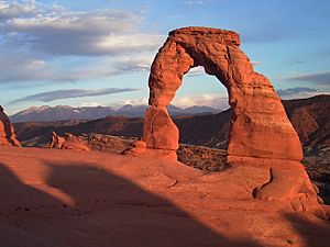
Grand County's landscape is dry, rugged, and beautifully shaped by water and wind. This has created amazing red rock formations, which bring many tourists to the area. There isn't much farming unless there's a way to water the land. The area has many hills and bumps, but it generally slopes towards the south and west.
The highest point in the county is Mount Waas, located in the southeast, which is about 12,336 feet (3,760 meters) above sea level. The county covers a total area of about 3,684 square miles (9,541 square kilometers). Most of this is land (3,672 sq mi or 9,510 km2), with a small amount of water (12 sq mi or 31 km2). The scenery is made up of deserts, cliffs, and flat-topped hills called plateaus. There are not many towns, except for Moab, which is like an oasis near the Colorado River. Arches National Park is in the southern part of the county, just north of Moab. A part of Canyonlands National Park is in the southwest corner.
Travel and Roads
Airport
- Canyonlands Field (CNY) is an airport located northwest of Moab.
Major Highways
- United States Interstate I-70
- US-191
- Utah State Highway UT-128
- Utah State Highway UT-313
Neighboring Counties
- Uintah County - north
- Garfield County, Colorado - northeast
- Mesa County, Colorado - east
- Montrose County, Colorado - southeast
- San Juan County - south
- Emery County - west
- Carbon County - northwest
Protected Natural Areas
- Arches National Park
- Canyonlands National Park (part)
- Dead Horse Point State Park (part)
- Manti-La Sal National Forest (part)
- McInnis Canyons National Conservation Area (part)
Lakes and Reservoirs
- Beaver Pond
- Big Flat Reservoir
- Blue Flat Reservoir
- Crescent Wash Reservoir
- Dead Sheep Pond
- Dons Lake
- Hidden Lake
- Holding Pond
- Jackson Reservoir
- Ken's Lake
- Mud Lake
- Oowah Lake
- Pace Lake
- Rock Corral Reservoir
- Strychnine Pond
- Tenmile Wash Reservoir
- Tie Pond
- Twin Pond
- Valley City Reservoir
- Warner Lake
- Weaver Reservoir
- Yellow Cat Reservoir
People of Grand County
In 2020, Grand County had a population of 9,669 people. This means there were about 2.6 people per square mile.
Most people in Grand County are White (about 77.4%). There are also Native American (3.4%), African American (0.7%), Asian (0.8%), and Pacific Islander (0.1%) residents. About 12.7% of the people are Hispanic or Latino.
The population is pretty evenly split between males and females. About 21.2% of the people are under 18 years old, and 18.6% are 65 or older. The average age in the county is about 40.5 years.
There are about 4,006 households in Grand County. Many of these are families, including married couples and single-parent households. About 28% of all households have children under 18. Most households (65.7%) own their homes, while others rent.
The average income for a household in Grand County was about $56,639. About 14% of the population lives below the poverty line.
When it comes to education, most adults in Grand County have at least a high school diploma. Many have also attended some college or earned a college degree.
Religion in Grand County
Grand County has the lowest percentage of members of the Church of Jesus Christ of Latter-day Saints (LDS Church) compared to all other counties in Utah. About 26% of people in Grand County identify as Latter-day Saints. This is much lower than the 62% for Utah as a whole.
Dinosaur Discoveries
Grand County is a cool place for finding dinosaur fossils! The Denver Museum of Natural History found a small quarry here. This quarry has given us many different dinosaur fossils, including meat-eating dinosaurs (like theropods), long-necked plant-eaters (like sauropods), and bird-hipped dinosaurs (like ornithopods). One adult sauropod found here was even named Venenosaurus.
Communities in Grand County
Cities
- Moab (This is the main city and where the county government is located.)
Towns
Census-Designated Places
- Thompson Springs (These are areas that are like towns but don't have their own local government.)
Unincorporated Communities
- Castleton
- Cisco
- Dewey
- Mesa
- Richardson
- Westwater (These are small communities that are not officially part of a city or town.)
Former Communities
See also
 In Spanish: Condado de Grand (Utah) para niños
 | Jackie Robinson |
 | Jack Johnson |
 | Althea Gibson |
 | Arthur Ashe |
 | Muhammad Ali |


