
Montrose County, Colorado facts for kids
Quick facts for kids
Montrose County
|
|
|---|---|
.jpg)
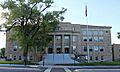
The Montrose County Courthouse in Montrose.
|
|

Location within the U.S. state of Colorado
|
|
 Colorado's location within the U.S. |
|
| Country | |
| State | |
| Founded | February 11, 1883 |
| Named for | City of Montrose |
| Seat | Montrose |
| Largest city | Montrose |
| Area | |
| • Total | 2,243 sq mi (5,810 km2) |
| • Land | 2,241 sq mi (5,800 km2) |
| • Water | 1.9 sq mi (5 km2) 0.08%% |
| Population
(2020)
|
|
| • Total | 42,679 |
| • Estimate
(2023)
|
44,156 |
| • Density | 19/sq mi (7/km2) |
| Time zone | UTC−7 (Mountain) |
| • Summer (DST) | UTC−6 (MDT) |
| Congressional district | 3rd |
Montrose County is a place in the state of Colorado, USA. It is one of the 64 counties in Colorado. In 2020, about 42,679 people lived there. The main town, called the county seat, is Montrose. The county is named after this town.
Contents
About Montrose County
Montrose County is quite large! It covers about 2,243 square miles (5,810 square kilometers). Most of this area is land. Only a small part, about 1.9 square miles (4.9 square kilometers), is water.
Neighboring Counties
Montrose County shares its borders with several other counties:
- Mesa County to the north
- Delta County to the northeast
- Gunnison County to the east
- Ouray County to the southeast
- San Miguel County to the south
- San Juan County in Utah to the west
Main Roads
Several important highways run through Montrose County. These roads help people travel and transport goods.
 U.S. Highway 50
 U.S. Highway 550
 State Highway 90
 State Highway 92
 State Highway 141
 State Highway 145
 State Highway 348
Nature and Parks
Montrose County is home to many beautiful natural areas. These places are protected to keep them wild and healthy.
- Black Canyon of the Gunnison National Park
- Black Canyon of the Gunnison Wilderness
- Curecanti National Recreation Area (part)
- Dominguez-Escalante National Conservation Area (part)
- Gunnison Gorge National Conservation Area (part)
- Gunnison Gorge Wilderness
- Gunnison National Forest (part)
- Manti-La Sal National Forest (part)
- Old Spanish National Historic Trail
- Uncompahgre National Forest (part)
Rivers in the County
Several rivers flow through Montrose County, adding to its natural beauty.
- Dolores River (part)
- Uncompahgre River (part)
- San Miguel River (part)
- Gunnison River (part)
Trails and Scenic Routes
You can find many trails and scenic routes for exploring the area.
- Great Parks Bicycle Route
- Unaweep/Tabeguache Scenic and Historic Byway
- West Elk Loop Scenic Byway
- Western Express Bicycle Route
Historical Places
Montrose County also has interesting historical sites.
People of Montrose County
| Historical population | |||
|---|---|---|---|
| Census | Pop. | %± | |
| 1890 | 3,980 | — | |
| 1900 | 4,535 | 13.9% | |
| 1910 | 10,291 | 126.9% | |
| 1920 | 11,852 | 15.2% | |
| 1930 | 11,742 | −0.9% | |
| 1940 | 15,418 | 31.3% | |
| 1950 | 15,220 | −1.3% | |
| 1960 | 18,286 | 20.1% | |
| 1970 | 18,366 | 0.4% | |
| 1980 | 24,352 | 32.6% | |
| 1990 | 24,423 | 0.3% | |
| 2000 | 33,432 | 36.9% | |
| 2010 | 41,276 | 23.5% | |
| 2020 | 42,679 | 3.4% | |
| 2023 (est.) | 44,156 | 7.0% | |
| U.S. Decennial Census 1790-1960 1900-1990 1990-2000 2010-2020 |
|||
In 2010, there were 41,276 people living in Montrose County. The population density was about 18 people per square mile. Most people (86.7%) were White. About 19.7% of the people were of Hispanic or Latino background.
Many families live in the county. About 31.2% of households had children under 18 living with them. The average household had about 2.47 people. The average family had about 2.97 people.
The people in Montrose County are of different ages. About 24.7% were under 18 years old. About 17.8% were 65 years or older. The average age was 42 years.
Culture
Towns and Communities
Montrose County has several towns and communities.
Cities
Towns
Other Communities
These are smaller places that are not officially cities or towns.
Images for kids
-
The Montrose County Courthouse in Montrose.
See also
 In Spanish: Condado de Montrose para niños
