
Maher, Colorado facts for kids
Quick facts for kids
Maher, Colorado
|
|
|---|---|

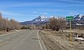
Maher in 2016, with Mount Lamborn in the distance
|
|

Maher, Colorado
Location in Colorado

Maher, Colorado
Location in the United States
|
|
| Country | |
| State | |
| Counties | Montrose |
| Elevation | 6,808 ft (2,075 m) |
| Time zone | UTC-7 (MST) |
| • Summer (DST) | UTC-6 (MDT) |
| ZIP code |
81415 (Crawford)
|
| Area code(s) | 970 |
| GNIS feature ID | 186732 |
Maher is a small, quiet place located in Montrose County, Colorado, in the United States. It's known as an unincorporated community. This means it doesn't have its own local government, like a mayor or city council. Instead, it's part of the larger county area.
Contents
What is an Unincorporated Community?
An unincorporated community is a group of homes or businesses that are not officially part of any town or city. They are governed by the county they are in.
How Maher is Governed
- People living in Maher follow the rules and laws set by Montrose County.
- Services like roads, police, and fire protection are often provided by the county.
- For postal services, Maher uses the U.S. Post Office in the nearby town of Crawford. Its ZIP Code is 81415.
Maher's Location and Surroundings
Maher is nestled in the beautiful state of Colorado. It sits at an elevation of about 6,808 feet (2,075 meters) above sea level.
Geographic Features
- The area around Maher is known for its natural beauty.
- As seen in pictures, Mount Lamborn is a notable mountain in the distance.
- The exact coordinates for Maher are 38°38′42″N 107°35′05″W.
Time Zone Information
- Maher is in the Mountain Standard Time (MST). This means it's 7 hours behind UTC.
- During Daylight Saving Time, it switches to Mountain Daylight Time (MDT), which is 6 hours behind UTC.
Images for kids
-
Maher in 2016, with Mount Lamborn in the distance

All content from Kiddle encyclopedia articles (including the article images and facts) can be freely used under Attribution-ShareAlike license, unless stated otherwise. Cite this article:
Maher, Colorado Facts for Kids. Kiddle Encyclopedia.