
San Miguel River (Colorado) facts for kids

The San Miguel River is a beautiful river located in southwestern Colorado, United States. It stretches for about 81 miles (130 kilometers). This river is a "tributary," which means it's a smaller river that flows into a larger one. The San Miguel River eventually joins the Dolores River.
Contents
Exploring the San Miguel River
Where Does the River Start?
The San Miguel River begins high up in the San Juan Mountains. These mountains are southeast of a famous town called Telluride. Imagine tiny streams forming from melting snow and rain in the mountains; these streams come together to create the San Miguel River.
The River's Journey
From its start, the San Miguel River flows mostly northwest. It travels along the southern side of a large landform known as the Uncompahgre Plateau. As it makes its way, the river passes by several towns. These include Placerville and Nucla.
The river continues its journey through western Montrose County. Finally, after its long trip, it meets and joins the Dolores River. This meeting point is about 15 miles (24 kilometers) east of the border with Utah.
What's Special About the San Miguel?
The San Miguel River is known for its clear waters and scenic beauty. It's a popular spot for outdoor activities like whitewater rafting and fishing. The river's path through canyons and valleys creates stunning views. It also provides water for local wildlife and communities along its banks.
Images for kids
-
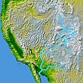
Geographical position of San Miguel River Colorado
-
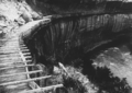
Hanging flume on the lower San Miguel River in 1891. Remnants of the flume may still be seen today.
-
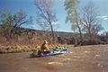
Paddler in an inflatable boat on the San Miguel River
-
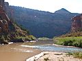
The mouth of the San Miguel - the confluence of the Dolores River (muddy on the left) and the San Miguel (clear on the right)
-
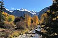
The headwaters of San Miguel River form at Ajax Peak, shown with the river.
-
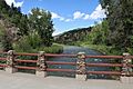
The river at Placerville, Colorado


.JPG)
