
Placerville, Colorado facts for kids
Quick facts for kids
Placerville, Colorado
|
|
|---|---|

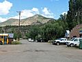
Front Street in Placerville.
|
|

Placerville, Colorado
Location in Colorado
|
|
| Country | |
| State | |
| County | San Miguel County |
| Government | |
| • Type | unincorporated community |
| Area | |
| • Total | 1.961 km2 (0.757 sq mi) |
| • Land | 1.961 km2 (0.757 sq mi) |
| • Water | 0.000 km2 (0 sq mi) |
| Elevation | 2,260 m (7,415 ft) |
| Population
(2020)
|
|
| • Total | 362 |
| • Density | 184.60/km2 (478.1/sq mi) |
| Time zone | UTC-7 (MST) |
| • Summer (DST) | UTC-6 (MDT) |
| ZIP Code |
81430
|
| Area code(s) | 970 |
| GNIS feature ID | 2805925 |
Placerville is a small community in San Miguel County, Colorado, United States. It's called a census-designated place (CDP), which means it's a special area defined by the government for counting people. Placerville also has its own post office with the ZIP Code 81430. In 2020, about 362 people lived in Placerville.
Contents
Exploring Placerville's Past
Placerville started as a small camp for miners. It got its name from the "placer" gold mines nearby. These mines were along the San Miguel River and Leopard Creek. Later, the Rio Grande Southern Railroad built a train station and tracks west of the original camp. They called this new spot Placerville, and the old area became "Old Placerville."
Mining for Vanadium
In the late 1890s, a person named A. B. Frenzel found a special type of rock near Placerville. This rock contained a metal called vanadium. The vanadium was found in layers within the Entrada Sandstone rock formation. The main mineral found was roscoelite. There were also smaller amounts of montroseite and carnotite.
By 1899, Frenzel had started digging a tunnel to explore the rock. By 1901-1902, he was digging up thousands of tons of this rock to send to Europe. Most of the rock from Placerville had less than 3% vanadium. This was not enough to make it worth sending all the way to Europe.
So, in 1905, a company called Vanadium Alloys Co. built a mill near Placerville. This mill processed the rock to get the vanadium out. They turned it into a product called ferro-vanadium, which they then sold. At one point, at least five mines were active in the area. By 1919, the two mills in Placerville were producing 30% of all the vanadium in the world! By 1940, these mines had produced about 3.7 million pounds of vanadium.
School Days and Floods
The Placerville Schoolhouse was a one-room schoolhouse that taught children from 1908 to 1960. It was a central part of the community for many years.
In 1909, the Trout Lake Dam broke. This caused a big flood that affected Placerville. Other nearby towns like Sawpit and Newmire were also flooded.
Later, around 1950, people realized that the rock from the vanadium mines also had a small amount of uranium. So, they started recovering uranium from the ore as well.
Placerville's Location and Weather
Placerville is a small area, covering about 1.961 square kilometers (or 0.757 square miles). All of this area is land.
Understanding the Climate
Placerville has a type of weather called a warm-summer humid continental climate. This means it has warm summers and cold winters. The highest temperature ever recorded in Placerville was 95°F (35°C). This happened on July 23, 2020, and again on June 12-13, 2021. The coldest temperature ever recorded was -17°F (-27°C). This happened on February 2, 2011, and January 15, 2013.
| Climate data for Placerville, Colorado, 1991–2020 normals, extremes 2008–present | |||||||||||||
|---|---|---|---|---|---|---|---|---|---|---|---|---|---|
| Month | Jan | Feb | Mar | Apr | May | Jun | Jul | Aug | Sep | Oct | Nov | Dec | Year |
| Record high °F (°C) | 62 (17) |
64 (18) |
72 (22) |
80 (27) |
87 (31) |
95 (35) |
95 (35) |
93 (34) |
92 (33) |
86 (30) |
71 (22) |
63 (17) |
95 (35) |
| Mean daily maximum °F (°C) | 40.1 (4.5) |
42.6 (5.9) |
51.6 (10.9) |
58.2 (14.6) |
67.9 (19.9) |
79.8 (26.6) |
83.0 (28.3) |
79.7 (26.5) |
73.9 (23.3) |
61.8 (16.6) |
49.8 (9.9) |
40.4 (4.7) |
60.7 (16.0) |
| Daily mean °F (°C) | 26.3 (−3.2) |
29.2 (−1.6) |
36.9 (2.7) |
43.2 (6.2) |
51.4 (10.8) |
62.2 (16.8) |
66.7 (19.3) |
64.4 (18.0) |
57.9 (14.4) |
45.8 (7.7) |
34.3 (1.3) |
26.4 (−3.1) |
45.4 (7.4) |
| Mean daily minimum °F (°C) | 12.5 (−10.8) |
15.7 (−9.1) |
22.3 (−5.4) |
28.3 (−2.1) |
34.9 (1.6) |
44.6 (7.0) |
50.3 (10.2) |
49.1 (9.5) |
41.9 (5.5) |
29.8 (−1.2) |
18.8 (−7.3) |
12.3 (−10.9) |
30.0 (−1.1) |
| Mean minimum °F (°C) | −4.7 (−20.4) |
−3.2 (−19.6) |
5.9 (−14.5) |
14.2 (−9.9) |
24.2 (−4.3) |
32.4 (0.2) |
42.4 (5.8) |
42.6 (5.9) |
30.4 (−0.9) |
16.5 (−8.6) |
4.7 (−15.2) |
−6.6 (−21.4) |
−9.1 (−22.8) |
| Record low °F (°C) | −17 (−27) |
−17 (−27) |
−6 (−21) |
4 (−16) |
19 (−7) |
29 (−2) |
34 (1) |
32 (0) |
24 (−4) |
2 (−17) |
−12 (−24) |
−16 (−27) |
−17 (−27) |
| Average precipitation inches (mm) | 1.42 (36) |
1.53 (39) |
1.83 (46) |
1.61 (41) |
1.83 (46) |
0.81 (21) |
2.47 (63) |
2.56 (65) |
2.52 (64) |
2.17 (55) |
1.62 (41) |
1.15 (29) |
21.52 (546) |
| Average snowfall inches (cm) | 13.1 (33) |
12.5 (32) |
13.2 (34) |
9.3 (24) |
1.3 (3.3) |
0.1 (0.25) |
0.0 (0.0) |
0.0 (0.0) |
0.3 (0.76) |
2.6 (6.6) |
10.2 (26) |
13.6 (35) |
76.2 (194.91) |
| Average extreme snow depth inches (cm) | 13.8 (35) |
17.2 (44) |
10.6 (27) |
4.1 (10) |
1.4 (3.6) |
0.0 (0.0) |
0.0 (0.0) |
0.0 (0.0) |
0.0 (0.0) |
2.3 (5.8) |
6.1 (15) |
10.9 (28) |
18.3 (46) |
| Average precipitation days (≥ 0.01 in) | 7.6 | 8.4 | 8.6 | 8.8 | 7.4 | 4.5 | 9.6 | 13.6 | 9.8 | 7.0 | 6.2 | 7.9 | 99.4 |
| Average snowy days (≥ 0.1 in) | 6.6 | 7.5 | 6.6 | 4.5 | 0.8 | 0.1 | 0.0 | 0.0 | 0.3 | 1.3 | 4.1 | 6.1 | 37.9 |
| Source 1: NOAA | |||||||||||||
| Source 2: National Weather Service (mean maxima and minima, snow depth 2008-2022) | |||||||||||||
Placerville's Population Over Time
| Placerville CDP, Colorado | ||
|---|---|---|
| Year | Pop. | ±% |
| 2020 | 362 | — |
| Source: United States Census Bureau | ||
The United States Census Bureau officially defined the Placerville CDP for the United States Census 2020. This is how they count the number of people living in the area.
Getting Around Placerville
Placerville is part of Colorado's Bustang network. This is a bus service that helps people travel around the state. Placerville is a stop on the Durango-Grand Junction Outrider line.
Images for kids
-
Front Street in Placerville.
See also
 In Spanish: Placerville (Colorado) para niños
