
Trout Lake (Colorado) facts for kids
Quick facts for kids Trout Lake |
|
|---|---|

Looking southeast towards Trout Lake with Yellow Mountain in view
|
|

Trout Lake
Location in Colorado

Trout Lake
Location in the United States
|
|
| Location | San Miguel County, Colorado, United States |
| Coordinates | 37°49′38″N 107°53′00″W / 37.82722°N 107.88333°W |
| Type | Reservoir |
| Primary inflows | Lake Fork Lizard Head Creek |
| Primary outflows | Lake Fork |
| Basin countries | United States |
| Surface area | 44.5 ha (110 acres) |
| Water volume | 5,000 acre⋅ft (0.0062 km3) |
| Surface elevation | 9,716 feet (2,961 m) |
Trout Lake is a beautiful lake found in the southeastern part of San Miguel County, Colorado. It's located within the huge Uncompahgre National Forest. Getting there is easy! It's just a 15-minute drive from Ophir and about 30 minutes from Telluride using Colorado State Highway 145.
Contents
Discovering Trout Lake's Past
Trout Lake has a long and interesting history. It was first explored by American fur-trappers and early pioneers. They often used the lake as a place to stop and rest during their long trips. The area around Trout Lake grew more populated after the Rio Grande Southern Railroad was built and the nearby Ames Hydroelectric Generating Plant started working in the 1890s.
Early Explorers and Settlers
We don't know if Native American, Spanish, or Mexican explorers visited Trout Lake before. But the first written record of the lake comes from an American fur trapping trip. In the spring of 1831, a group of 60 men from the St. Louis Fur Company explored the area. They were led by Colonel William G Walton. Their goal was to trap beavers and other animals for their fur near the San Juan River. This group spent the summer of 1833 in the valley of the Rio Dolores and at Trout Lake.
On June 14, 1882, the first post office opened at Trout Lake. Back then, it was described as "a post office, with a small lake near it" and a "miner's camp of about 20 people." Between 1875 and 1885, many prospectors visited the area looking for mines. However, after 10 years, no mines were found near Trout Lake, and the post office closed. In the 1885 Colorado Census, Trout Lake had 40 residents.
The post office reopened between 1890 and 1892. This happened because the Rio Grande Southern Railroad was being built in 1891.
On June 13, 1905, Trout Lake became part of the new Montezuma Forest Reserve. This was made official by President Theodore Roosevelt. The Montezuma Forest Reserve became a full National Forest on March 4, 1907. Later, on July 1, 1947, the Montezuma National Forest was divided. Trout Lake then became part of the Uncompahgre National Forest.
The 1910 Census showed that Trout Lake had a population of 62 people.
Building the Trout Lake Dam
Trout Lake was naturally formed, but it was made bigger in 1894. This happened when the Trout Lake Dam was built by the Telluride Power Co. The dam's main purpose was to create more water storage for the Ames Hydroelectric Generating Plant. This power plant was located about 3.25 miles downstream. Even today, Trout Lake still provides water to the Ames Hydroelectric Plant. Water flows from the dam through a special concrete pipe called a Penstock.
The 1909 Flood Event
On September 5, 1909, heavy rains caused a big flood. This led to the failure of the Trout Lake and Middle Dams. A problem with the Middle Dam's water outlet likely caused the ground under the dam to wash away. When the dams broke, about 2,000 acre-feet of water rushed downstream. This water damaged livestock farms and destroyed many miles of railroad track. It also flooded nearby towns like Placerville, Sawpit, and Newmire. Luckily, no one was hurt in the flood, and the Ames Hydroelectric plant was mostly okay. The damage to property was estimated to be about $200,000 at the time.
In 1910, the dam was rebuilt. This time, it was made with strong soil and rock instead of timber.
In 1954, the dam's spillway was rebuilt to help prevent future floods at Trout Lake. The new spillway included two steel siphons. These siphons release water about 200 feet downstream from the dam into Lake Fork.

The Rio Grande Southern Railroad
Starting in 1891, Trout Lake became an important stop for the Rio Grande Southern Railroad (RGS). The trains used water from the lake to fill their steam engines. There were 15 similar watering stations along the RGS line. A special team of men called "water service" kept these water tanks working. The railroad is no longer in use, but a 50,000-gallon wooden watering tank still stands there. It's one of only two left! A nearby railroad trestle also remains.
After the railroad stopped running in 1952, the trestle was used as a car bridge for several years. Later, a new road was built around it. The trestle was added to the Colorado State Register of Historic Properties on May 14, 1997. In 2004, the trestle was made stronger and safer. This work was funded by several groups, including the Colorado Historical Fund and the US Forest Service.
Fun Activities at Trout Lake
Trout Lake has been a popular spot for visitors since the 1920s, especially for fishing. Today, there are many fun things to do around the lake:
- Hiking: You can explore several hiking trails.
- Cross-country skiing: In winter, the Telluride Nordic Association prepares the trails for cross-country skiing.
- Boating: The lake is a great place for boating.
- Fishing: It's still a favorite spot for fishing!
Gallery
-
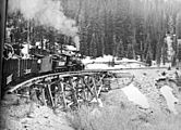
Historic photo of a Rio Grande Southern train passing over the Trout Lake Trestle during winter (date unknown)
-
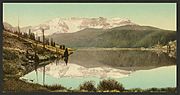
A historical photo of Trout Lake taken between 1898 and 1905
-
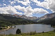
Looking east towards trout lake in August 2011
-
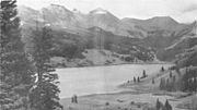
A photo of Trout Lake with the San Juan Mountains in the background, taken in 1939 or earlier


