
Mesa County, Colorado facts for kids
Quick facts for kids
Mesa County
|
|
|---|---|

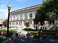
Old Mesa County Courthouse in Grand Junction
|
|

Location within the U.S. state of Colorado
|
|
 Colorado's location within the U.S. |
|
| Country | |
| State | |
| Founded | February 14, 1883 |
| Named for | Mesas in the area |
| Seat | Grand Junction |
| Largest city | Grand Junction |
| Area | |
| • Total | 3,341 sq mi (8,650 km2) |
| • Land | 3,329 sq mi (8,620 km2) |
| • Water | 12 sq mi (30 km2) 0.4%% |
| Population
(2020)
|
|
| • Total | 155,703 |
| • Estimate
(2023)
|
159,681 |
| • Density | 47/sq mi (18/km2) |
| Time zone | UTC−7 (Mountain) |
| • Summer (DST) | UTC−6 (MDT) |
| Congressional district | 3rd |

Mesa County is a special area in the U.S. state of Colorado. It is called a county. As of 2020, about 155,703 people lived here. This makes it the most populated county in western Colorado. It is also the 11th most populated county in the whole state.
The main town and biggest city in Mesa County is Grand Junction. This city is also called the county seat. The county got its name from the many large, flat-topped mountains called mesas in the area. One of these is the Grand Mesa, which is the biggest flat-topped mountain in the world!
Mesa County is part of the Grand Junction Metropolitan Statistical Area. This is a way to describe a city and its nearby towns that are closely connected. In 2020, it was the 271st largest metropolitan area in the United States. It is also the only metropolitan area in Colorado that is not located along the Front Range.
Contents
Exploring Mesa County's Geography
Mesa County is a large place! It covers a total area of about 3,341 square miles. Most of this area, about 3,329 square miles, is land. Only a small part, about 12 square miles, is water. This makes Mesa County the fourth-largest county in Colorado by size.
Neighboring Counties Around Mesa County
Mesa County shares its borders with several other counties. These are like its neighbors:
- Garfield County – to the north
- Pitkin County – to the east
- Gunnison County – to the east
- Delta County – to the southeast
- Montrose County – to the south
- Grand County, Utah – to the west
Main Roads and Highways in Mesa County
Many important roads run through Mesa County, helping people travel around.
 Interstate 70
 I-70 Bus.
- I-70 Bus.
 U.S. Highway 6
 U.S. Highway 50
 State Highway 65
 State Highway 139
 State Highway 141
 State Highway 330
 State Highway 340
- 45 1/2 Rd
Special Protected Natural Areas
Mesa County is home to many beautiful natural areas that are protected. These include:
- Black Ridge Canyons Wilderness
- Colorado National Monument
- Dominguez Canyon Wilderness
- Dominguez-Escalante National Conservation Area (part)
- Grand Mesa National Forest
- Manti-La Sal National Forest
- McInnis Canyons National Conservation Area (part)
- Uncompahgre National Forest
- White River National Forest
State Parks and Protected Lands
Colorado also protects several areas within Mesa County:
- Highline Lake State Park
- James M. Robb – Colorado River State Park
- Vega State Park
Fun Trails and Scenic Drives
You can find many trails and scenic byways in Mesa County for outdoor adventures:
- American Discovery Trail
- Dinosaur Diamond Prehistoric Highway National Scenic Byway
- Grand Mesa National Scenic and Historic Byway
- Kokopelli Trail
- Old Spanish National Historic Trail
- Unaweep/Tabeguache Scenic and Historic Byway
- Colorado Riverfront Trail
Mesa County's Population Story
| Historical population | |||
|---|---|---|---|
| Census | Pop. | %± | |
| 1890 | 4,260 | — | |
| 1900 | 9,267 | 117.5% | |
| 1910 | 22,197 | 139.5% | |
| 1920 | 22,281 | 0.4% | |
| 1930 | 25,908 | 16.3% | |
| 1940 | 33,791 | 30.4% | |
| 1950 | 38,794 | 14.8% | |
| 1960 | 50,715 | 30.7% | |
| 1970 | 54,734 | 7.9% | |
| 1980 | 81,530 | 49.0% | |
| 1990 | 93,145 | 14.2% | |
| 2000 | 116,255 | 24.8% | |
| 2010 | 146,723 | 26.2% | |
| 2020 | 155,703 | 6.1% | |
| 2023 (est.) | 159,681 | 8.8% | |
| U.S. Decennial Census 1790-1960 1900-1990 1990-2000 2010-2020 |
|||
In 2010, there were 146,723 people living in Mesa County. There were also 58,095 households. A household means all the people living in one home. The population density was about 44 people per square mile.
Most people in Mesa County are White. About 10% of the population is of Hispanic or Latino background.
Learning and Education in Mesa County
Mesa County has great schools for students of all ages.
Local School Districts
Most of Mesa County is served by the Mesa County Valley School District 51. This district includes towns like Grand Junction, Fruita, Palisade, and De Beque. It is the largest school district in western Colorado, with nearly 21,000 students in 47 schools.
The Plateau Valley School District serves the more distant eastern parts of the county. This district helps students in towns like Collbran, Mesa, and Molina.
Colleges and Universities
Colorado Mesa University is a public university in Grand Junction. About 9,000 students attend this university each year. It is the biggest university in western Colorado. This makes Mesa County an important place for higher education in the region. Grand Junction also has IntelliTec College, which offers special training for jobs.
Towns and Cities in Mesa County
Mesa County has several communities where people live, work, and go to school.
Cities
- Fruita
- Grand Junction (This is the county seat, the main town for county government)
Towns
Special Designated Places
These are areas that are like towns but are not officially incorporated as cities or towns:
Other Small Communities
You can also find these smaller, unincorporated places in Mesa County:
Getting Around Mesa County: Transportation
Mesa County has different ways to travel, whether by road, air, or train.
Road Travel
 Interstate 70 is a major highway that goes all the way from Utah to Maryland. It connects Grand Junction to big cities like Denver, Kansas City, and St. Louis. It also links to Las Vegas, Nevada, and southern California through another highway.
 U.S. Highway 6 is another long highway that crosses 14 states, from Massachusetts to California. In Colorado, it runs near Interstate 70.
 U.S. Highway 50 goes across 12 states, from Maryland to California. In Colorado, it connects Grand Junction to towns like Montrose and Pueblo. It also goes into Utah.
 SH 340 is a state highway that starts in downtown Grand Junction. It goes through the Redlands area and ends in Fruita.
Air Travel
If you want to fly, the Grand Junction Regional Airport is very close to downtown Grand Junction. There are also smaller airports like Mack Mesa Airport and Pinyon Airport.
Train Travel
An Amtrak train station is located in downtown Grand Junction. The California Zephyr train stops here every day. You can take this train to places like San Francisco or Chicago.
Bus Services
There is a regional Bustang bus stop in Grand Junction. Also, Grand Valley Transit provides local bus services with eleven different routes around the area.
Images for kids
-
Old Mesa County Courthouse in Grand Junction
See also
 In Spanish: Condado de Mesa para niños
