Redlands, Colorado facts for kids
Quick facts for kids
Redlands, Colorado
|
|
|---|---|

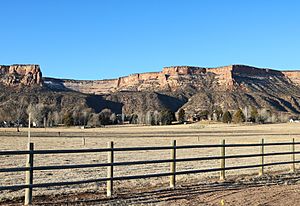
The northern part of Redlands in 2020
|
|

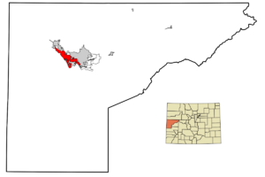
Location in Mesa County, Colorado
|
|
| Country | |
| State | Colorado |
| County | Mesa County |
| Government | |
| • Type | unincorporated community |
| Area | |
| • Total | 13.446 sq mi (34.82 km2) |
| • Land | 12.905 sq mi (33.42 km2) |
| • Water | 0.541 sq mi (1.40 km2) |
| Elevation | 4,643 ft (1,415 m) |
| Population
(2020)
|
|
| • Total | 9,061 |
| • Density | 702.1/sq mi (271.1/km2) |
| Time zone | UTC-7 (MST) |
| • Summer (DST) | UTC-6 (MDT) |
| ZIP Code |
81507 (Grand Junction)
|
| Area code(s) | 970 |
| GNIS feature | 2409153 |
Redlands is a community in Mesa County, Colorado, United States. It's a special kind of place called a "census-designated place" (CDP). This means it's an area that the government counts for population, but it doesn't have its own city government.
Redlands is part of the larger Grand Junction area. In 2020, about 9,061 people lived there. The local post office for Redlands is in Grand Junction, with the ZIP Code 81507.
Where is Redlands Located?
Redlands is in the middle of Mesa County. It sits on the southwest side of the Colorado River. To its east is the city of Grand Junction. To the northwest, you'll find the city of Fruita.
The total area of Redlands is about 13.4 square miles. A small part of this area, about 0.54 square miles, is water.
How Many People Live Here?
The United States Census Bureau first counted Redlands as a CDP in 1990. Since then, the population has changed a bit.
Here's how the population has looked over the years:
- 1990: 9,355 people
- 2000: 8,043 people
- 2010: 8,685 people
- 2020: 9,061 people
See also
 In Spanish: Redlands (Colorado) para niños
 | Ernest Everett Just |
 | Mary Jackson |
 | Emmett Chappelle |
 | Marie Maynard Daly |


