Mesa, Colorado facts for kids
Quick facts for kids
Mesa, Colorado
|
|
|---|---|

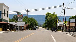
Looking towards the Grand Mesa in Mesa on Highway 65
|
|
| Country | |
| State | |
| County | Mesa |
| Elevation | 5,643 ft (1,720 m) |
| Time zone | UTC-7 (MST) |
| • Summer (DST) | UTC-6 (MDT) |
| ZIP code |
81643
|
| Area code(s) | 970 |
| GNIS feature ID | 174463 |
Mesa is a small, quiet community located in Mesa County, Colorado, in the United States. It is not a city or town with its own local government. Instead, it is an unincorporated community. This means it is part of the larger county area.
Contents
Where is Mesa Located?
Mesa is found on the northern side of the Grand Mesa. This is a very large flat-topped mountain. The community sits along Highway 65. This area is also known as Plateau Valley.
What is a Plateau Valley?
A plateau valley is a valley that is surrounded by high, flat landforms called plateaus. In Mesa's case, the Grand Mesa is the main plateau nearby. This gives the area its unique look.
Life in Mesa
Even though Mesa is a small community, it has its own ZIP Code, which is 81643. The local schools in the area are part of the Plateau Valley 50 District Public Schools. This district serves students living in Mesa and the surrounding valley.
What is an Unincorporated Community?
An unincorporated community is a place that does not have its own separate local government. It is managed directly by the county. For Mesa, this means Mesa County handles services like roads and law enforcement. People living in unincorporated areas still follow state and county laws.
See also
 In Spanish: Mesa (Colorado) para niños
 | DeHart Hubbard |
 | Wilma Rudolph |
 | Jesse Owens |
 | Jackie Joyner-Kersee |
 | Major Taylor |


