Black Ridge Canyons Wilderness facts for kids
Quick facts for kids Black Ridge Canyons Wilderness |
|
|---|---|
|
IUCN Category Ib (Wilderness Area)
|
|

Knowles Canyon
|
|
| Location | Mesa County, Colorado / Grand County, Utah, USA |
| Nearest city | Grand Junction |
| Area | 75,439 acres (30,529 ha) |
| Established | October 24, 2000 |
| Governing body | U.S. Bureau of Land Management |
The Black Ridge Canyons Wilderness (BRCW) is a special natural area in western Colorado. A small part of it also stretches into eastern Utah in the USA. It's about 15 miles (24 km) west of Grand Junction, Colorado. This wilderness is part of the dry Colorado Plateau region.
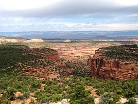
The area is known for its high Black Ridge, which runs from east to west. Seven large canyon systems cut through this ridge. These canyons drain into the Colorado River in Ruby Canyon. The land here ranges from 4,700 feet (1,400 m) above sea level near the river to 6,800 feet (2,100 m) at its highest points.
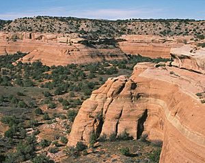
Some canyons are several miles long, while others stretch up to twelve miles. They often have cool side canyons to explore. You can see amazing rock shapes like spires, natural windows, and giant alcoves. The rocks are often covered in "desert varnish," which is a dark coating. Some canyons are almost 1,000 feet (300 m) deep, forming incredible red rock cliffs. After spring snow melts or summer thunderstorms, you might even see sparkling waterfalls and plunge pools.
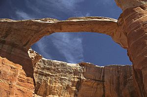
Rattlesnake Canyon is famous for having the second-largest number of natural arches in the entire country. Only Arches National Park has more! Another remote spot is Mee Canyon, which is home to a unique rock formation called Arch Tower.
In the winding canyon bottoms, you'll find grasses, pinyon and juniper trees. There are also cottonwood, willow, and box elder trees. Up on the flat tops of the mesas, you'll see thick forests of pinyon and juniper, along with open areas of sagebrush. The soil here often has "cryptobiotic crusts," which are living layers of tiny organisms that help the soil stay healthy.
If you're lucky, you might spot some amazing wildlife. This includes deer, mountain lions, desert bighorn sheep, and even golden and bald eagles flying overhead. The Black Ridge Canyons Wilderness covers 75,439 acres (305.3 km2). Most of it, 70,319 acres (284.6 km2), is in Colorado, and 5,120 acres (20.7 km2) are in Utah. The U.S. Congress officially made it a wilderness area in 2000. The Bureau of Land Management takes care of it. This wilderness is the main part of the larger 123,430-acre (500 km2) McInnis Canyons National Conservation Area.
Contents
How to Visit Black Ridge Canyons Wilderness
There are three main ways to get into the Black Ridge Canyons Wilderness. These are the "front country" (easy access near Fruita), the "high country" (from Glade Park), and by floating down the Colorado River. Some areas are easy to reach all year, while others are only for more adventurous visitors.
Easy Access: The Front Country
The front country part of the BRCW is just a few minutes from the town of Fruita, Colorado. You can get there by taking State Highway 340. This area is very popular with local people and their pets who want to get some daily exercise. The Bureau of Land Management manages three trailheads here: Devils Canyon, Fruita Paleontological Area, and Pollock Bench.
Exploring the High Country
You can reach the high country of the BRCW from the community of Glade Park, Colorado. Visitors to this area will find a true wilderness experience. It's a rugged and remote place that offers great chances for peace and quiet. The Rattlesnake Canyon area is found here. It has the world's second-largest group of natural arches, after Arches National Park.
Mee Canyon has a 300-foot (91 m) deep alcove. You can only reach it by a difficult hiking trail. This trail requires scrambling over many exposed ledges. Knowles and Jones Canyons also offer a real wilderness adventure. They provide excellent chances for solitude and a primitive, unconfined type of recreation.
Adventures on the Colorado River
The Colorado River flows through the McInnis Canyons National Conservation Area. It forms the northern edge of the Black Ridge Canyons Wilderness as it winds through Horsethief and Ruby canyons. The river itself is not part of the wilderness. However, people floating on the river can hike up many of the main canyons. These include Rattlesnake Canyon, Moore Canyon, Mee Canyon, and Knowles Canyon.
The most popular place to start a float trip on this part of the river is the Loma boat launch in Loma, Colorado. Most river users finish their trip in Westwater, Utah. Some continue through the more challenging Class III and IV rapids of Westwater Canyon. A permit is needed for that section.
 | Victor J. Glover |
 | Yvonne Cagle |
 | Jeanette Epps |
 | Bernard A. Harris Jr. |


