Loma, Colorado facts for kids
Quick facts for kids
Loma, Colorado
|
|
|---|---|

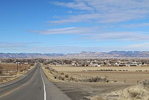
Loma and Colorado State Highway 139
|
|

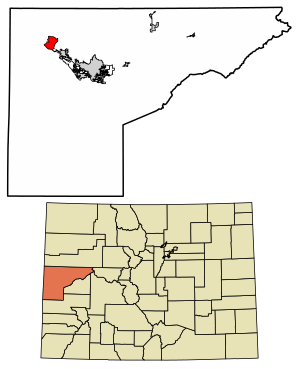
Location in Mesa County, Colorado
|
|
| Country | |
| State | |
| County | Mesa County |
| Government | |
| • Type | unincorporated town |
| Area | |
| • Total | 10.889 sq mi (28.20 km2) |
| • Land | 10.889 sq mi (28.20 km2) |
| • Water | 0.0 sq mi (0 km2) |
| Elevation | 4,524 ft (1,379 m) |
| Population
(2020)
|
|
| • Total | 1,314 |
| • Density | 120.67/sq mi (46.592/km2) |
| Time zone | UTC-7 (MST) |
| • Summer (DST) | UTC-6 (MDT) |
| ZIP Code |
81524
|
| Area code(s) | 970 |
| GNIS feature | 2629991 |
Loma is a small community located in Mesa County, Colorado, in the United States. It is an unincorporated town, which means it doesn't have its own city government. Instead, it's looked after by Mesa County. Loma is also a census-designated place (CDP), which is a special area defined by the government for counting people.
The name "Loma" comes from a Spanish word meaning "small hill." In 2020, about 1,314 people lived in Loma. It's part of the larger Grand Junction, CO Metropolitan Statistical Area.
Contents
Loma's Early Days
The area where Loma is now was first home to the Ute people. They lived there until about 1881.
Railroad and Farming Beginnings
In 1882, the Denver and Rio Grande Western Railroad built a narrow-gauge train track through Loma. This track was made wider in 1890.
People began to settle in Loma in the late 1880s. Farming quickly became very important. An irrigation canal, called the Kiefer Extension, was finished in 1899. This canal helped farmers water their crops. The railway made it easy to send crops and animals to big cities like Denver and Salt Lake City.
Schools and Sugar Beets
The first school in Loma opened in the 1890s. A bigger, two-story school was built in 1910 using yellow bricks made right there. This school was used until 1982, when Loma Elementary School opened.
In 1901, a company called Colorado Sugar opened up land near Loma for new settlers. Sugar beets became a main crop. Growing sugar beets was a big part of Loma's farming until the 1970s. Farmers also grew potatoes.
Community Life and Growth
The Loma post office opened in 1905 and has been open ever since. In 1910, the church known today as Loma Community Church was built. It's often called "The Church That Stayed."
A wealthy man named Verner Zevola Reed started a large apple orchard near Loma in 1907. A canning factory opened in 1911 to process the apples, but it closed a few years later.
Another irrigation canal, the Highline Canal, was built in 1917. This helped Loma's economy grow a lot in the 1920s, leading to many successful harvests. By 1923, Loma had many businesses and homes, including a school, a hotel, and grocery stores.
During the Great Depression, the government helped 32 families from the Dust Bowl move to Loma. In 1938, the Loma Community Hall was built for meetings and events. It's now a historic place.
Mining and Modern Times
In the 1940s, a uranium mine and mill were built near Loma. Towns with uranium mines were sometimes called "yellowcake towns" because the uranium they produced looked like yellow cake mix.
In the 1950s, a pipeline was built to carry a special tar-like material called gilsonite from Utah to Loma. A plant in Loma refined the gilsonite into gasoline and other products.
In 2015, Loma got its first traffic light at a busy intersection. Today, Loma is also near Country Jam, a popular country music festival.
Loma's Location and Landscape
Loma is in the northwestern part of Mesa County. It's about 18.5 miles (30 km) northwest of Grand Junction, which is the county seat.
Roads and Rivers
U.S. Route 6 goes right through the middle of Loma. Interstate 70 runs along the southern edge of the community. The Colorado River flows just south of Loma.
Loma covers an area of about 10.9 square miles (28.2 sq km), and all of it is land.
A Rural Feel
Loma is known for its open spaces, farms, and mixed types of homes. It has a rural feel, meaning it's quiet and spread out. People who live there often value small-town life, family, and hard work.
Population of Loma
According to the 2020 census, the population of Loma was 1,314 people.
Local Economy
Loma's economy is still based on farming. There are small cattle farms and places that grow crops. Many people also enjoy a lifestyle that includes some farming.
Fun and Recreation
Loma has a small park called Loma Community Park. It has a playground for kids.
There's a lot of public land around Loma, managed by the Bureau of Land Management. The Loma Boat Launch State Wildlife Area is a popular spot to get onto the Colorado River for fun activities. The start of the Kokopelli Trail, a 142-mile (229 km) long trail for recreation, is also nearby. This trail goes through the large McInnis Canyons National Conservation Area.
Learning in Loma
Students in Loma are part of the Mesa County Valley School District 51.
Loma Elementary School is in Loma. Its mascot is the lion, and its colors are green and white. After elementary school, students go to Fruita Middle School and Fruita Monument High School in Fruita.
Important People from Loma
- James Niehues – a famous artist known for drawing ski area trail maps.
- Eunice Parsons – an artist.
See also
 In Spanish: Loma (Colorado) para niños
 | Toni Morrison |
 | Barack Obama |
 | Martin Luther King Jr. |
 | Ralph Bunche |


