De Beque, Colorado facts for kids
Quick facts for kids
De Beque, Colorado
|
|
|---|---|

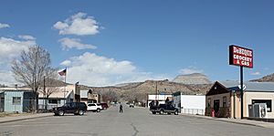
Minter Avenue in De Beque, March 2013
|
|

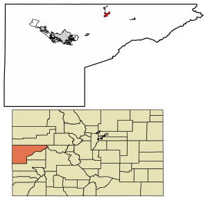
Location of the Town of De Beque in Mesa County, Colorado.
|
|
| Country | |
| State | |
| County | Mesa County |
| Settled | 1880 |
| Incorporated | January 18, 1890 |
| Government | |
| • Type | Statutory Town |
| Area | |
| • Total | 2.778 sq mi (7.196 km2) |
| • Land | 2.727 sq mi (7.063 km2) |
| • Water | 0.051 sq mi (0.133 km2) |
| Elevation | 4,954 ft (1,510 m) |
| Population
(2020)
|
|
| • Total | 493 |
| • Density | 183/sq mi (71/km2) |
| • Metro | 155,703 |
| Time zone | UTC−07:00 (MST) |
| • Summer (DST) | UTC−06:00 (MDT) |
| ZIP code |
81630
|
| Area code(s) | 970 |
| FIPS code | 08-19355 |
| GNIS feature ID | 2412412 |
De Beque is a small town in Mesa County, Colorado. It is known as a "statutory town," which means it follows certain state laws for how it is run. In 2020, about 493 people lived there. De Beque is part of the larger Grand Junction, CO Metropolitan Statistical Area. The town has a historic downtown with a town hall, a tavern, and some shops. You can also find houses, churches, and a school in the surrounding areas.
Contents
History of De Beque
Early Settlers and Naming
The area where De Beque is located was originally home to the Ute people. White settlers first arrived in this region around 1880.
The town got its name from Dr. W.A.E. de Beque. He explored the area in 1884 with friends, looking for a good place to start a ranch.
Wild Horses and Sanctuary City
Historically, De Beque was a place where wild horses from the surrounding lands were gathered and sold. Today, a statue of a Mustang horse near the town hall reminds everyone of this history.
In August 2001, the town decided to become the only Wild Horse Sanctuary City in the West. This means De Beque works with the Bureau of Land Management and other groups to protect the wild horses and burros still living in the area. They even built a public corral to care for injured or sick mustangs and burros until they can find new homes.
Geography of De Beque
Location and Surroundings
De Beque is located on the north side of the Colorado River. It sits in a small ranching valley about 25 miles (40 km) northeast of Grand Junction. The town is across the river from Interstate 70 and is built on a small hill overlooking the river.
The southwest edge of the Roan Cliffs can be seen from the town. Much of the nearby mountain area is managed by the Bureau of Land Management.
Size of the Town
According to the United States Census Bureau, De Beque covers a total area of about 0.4 square miles (1.0 km²). Most of this area, about 0.3 square miles (0.78 km²), is land. The rest, about 0.04 square miles (0.10 km²), is water.
Population Changes
| Historical population | |||
|---|---|---|---|
| Census | Pop. | %± | |
| 1900 | 83 | — | |
| 1910 | 149 | 79.5% | |
| 1920 | 292 | 96.0% | |
| 1930 | 347 | 18.8% | |
| 1940 | 280 | −19.3% | |
| 1950 | 253 | −9.6% | |
| 1960 | 172 | −32.0% | |
| 1970 | 155 | −9.9% | |
| 1980 | 279 | 80.0% | |
| 1990 | 257 | −7.9% | |
| 2000 | 451 | 75.5% | |
| 2010 | 504 | 11.8% | |
| 2020 | 493 | −2.2% | |
| U.S. Decennial Census | |||
The population of De Beque has changed over the years. You can see how the number of people living in the town has grown and shrunk since 1900 in the chart to the left. In 2020, the population was 493 people.
Art and Culture in De Beque
Wild Horse Days Festival
Since 2000, De Beque has hosted a special event called "Wild Horse Day" every August. This festival is a fun way to celebrate the town's connection to wild horses.
The festival usually includes a rodeo and a parade. It was started to help people learn more about the wild horse population. It also helps raise money for things like corrals and rodeo grounds.
See also
 In Spanish: De Beque para niños
 | Selma Burke |
 | Pauline Powell Burns |
 | Frederick J. Brown |
 | Robert Blackburn |


