
Airport Tower (Canyonlands) facts for kids
Quick facts for kids Airport Tower |
|
|---|---|

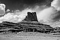
Southwest aspect from White Rim Road
|
|
| Highest point | |
| Elevation | 5,812 ft (1,771 m) |
| Prominence | 732 ft (223 m) |
| Isolation | 1.61 mi (2.59 km) |
| Parent peak | Monster Tower (5,880 ft) |
| Geography | |

Airport Tower
Location in Utah

Airport Tower
Location in the United States
|
|
| Location | Canyonlands National Park San Juan County, Utah, U.S. |
| Parent range | Colorado Plateau |
| Topo map | USGS Musselman Arch |
| Geology | |
| Age of rock | Late Triassic |
| Type of rock | Wingate Sandstone |
| Climbing | |
| Easiest route | class 5.10 A3 Climbing |
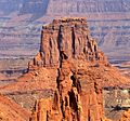
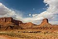
Airport Tower is a huge sandstone rock formation, about 700-foot (210-meter) tall. It's found in the Island in the Sky District of Canyonlands National Park in San Juan County, Utah. This park is a beautiful place with amazing rock shapes!
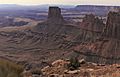
Airport Tower is located about 1.6 miles (2.6 km) east of Washer Woman, which is another tall rock formation. Both of these amazing structures are made of Wingate Sandstone. This type of rock formed from ancient sand dunes that blew around about 200 million years ago!
Other cool rock formations nearby include Monster Tower, which is about 1.6 miles (2.6 km) to the west. Tiki Tower is also close, about half a mile (0.8 km) northwest. Mesa Arch is about 3.2 miles (5.1 km) to the west. You can get a great view of Airport Tower by taking a short hike to Mesa Arch.
Another way to see Airport Tower is by driving on the White Rim Road. This road is for four-wheel-drive vehicles. The top of Airport Tower rises 1,400 feet (427 meters) above the road in less than a mile! Rainwater from Airport Tower flows southeast into the nearby Colorado River.
The name "Airport Tower" was officially chosen in 1986. It was given this name because the rock formation looks a lot like an airport control tower.
Climbing Airport Tower
People love to climb these tall rock formations! The very first time someone successfully climbed Airport Tower was in July 1994. The climbers were Galen Howell, Sonja Paspal, and Steve Swanke. They used a route called Wind Shear.
The second climb happened in September 1995. Mike Baker and Leslie Henderson made this climb using a route called Sky Pilot.
Later, in 1998, Bret Ruckman and Marco Corncchione made the first free ascent of Airport Tower. This means they climbed using only their hands and feet on the rock, with ropes just for safety. They used the Wind Shear route and said it was a "five-star" climb!
Weather Around Airport Tower
The best times to visit Airport Tower are during spring and fall. The weather is usually very nice then.
The area has a Cold semi-arid climate. This means that the coldest month of the year has an average temperature below 32°F (0°C). Also, at least half of the year's rain falls during spring and summer. This desert area gets less than 10 inches (250 millimeters) of rain each year. If it snows in winter, it's usually not very much.
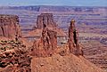
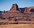
Gallery
-
Washer Woman and Airport Tower seen from the west at Mesa Arch
-
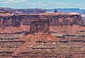
From the southwest
-
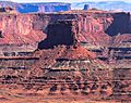
From the southwest
-
Washer Woman, Monster Tower, and Airport Tower seen from west
-
Airport Tower (right) and Island in the Sky
-
Airport Tower from the east (Monster Tower behind left)
-
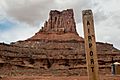
From Airport Tower Campground
-
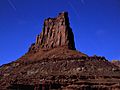
Southeast aspect and star trails
-
-
North aspect. (Tiki Tower to right)


.jpg)

.jpg)


