Monticello, Utah facts for kids
Quick facts for kids
Monticello, Utah
|
|
|---|---|

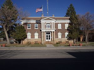
San Juan County Courthouse
|
|

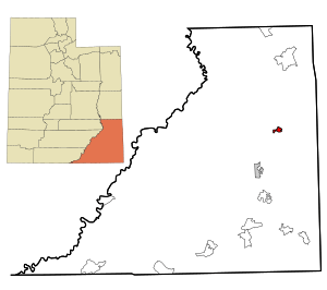
Location in San Juan County and the state of Utah.
|
|
| Country | United States |
| State | Utah |
| County | San Juan |
| Founded | 1887 |
| Named for | Monticello |
| Area | |
| • Total | 3.66 sq mi (9.49 km2) |
| • Land | 3.66 sq mi (9.49 km2) |
| • Water | 0.00 sq mi (0.00 km2) |
| Elevation | 7,021 ft (2,140 m) |
| Population
(2020)
|
|
| • Total | 1,824 |
| • Density | 537.39/sq mi (207.48/km2) |
| Time zone | UTC−7 (Mountain (MST)) |
| • Summer (DST) | UTC−6 (MDT) |
| ZIP code |
84535
|
| Area code(s) | 435 |
| FIPS code | 49-51580 |
| GNIS feature ID | 2411149 |
Monticello is a city in San Juan County, Utah, United States. It is the main city, or county seat, of San Juan County. In 2020, about 1,824 people lived there.
The area of Monticello was first settled in July 1887 by Mormon pioneers from the Church of Jesus Christ of Latter-day Saints. The city was named after Thomas Jefferson's famous home, Monticello. It became the county seat in 1895 and an official city in 1910.
Monticello grew a lot during the "uranium boom" from the late 1940s to the early 1960s. Many mines for uranium and vanadium opened nearby. The U.S. government even ran a uranium processing plant in Monticello from 1948 to 1960. After the boom, a big cleanup project took place from 1989 to 2004. This project removed old materials and restored the land where the plant used to be.
Today, Monticello is home to an 18-hole golf course called The Hideout Golf Club. This course was built near the cleaned-up site of the old uranium plant in 2000. It has been ranked as one of the best golf courses in Utah!
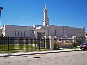
In 1998, The Church of Jesus Christ of Latter-day Saints built the Monticello Utah Temple here. It was the first of its kind and the 53rd temple for the church. Monticello is located at the base of the beautiful Abajo Mountains on the Colorado Plateau.
Contents
History of Monticello
The Old Spanish Trail, an old trading route, passed through the Monticello area from 1829 to the 1850s. Monticello is one of many cities started by Mormon pioneers in the Utah Territory. Farming, raising animals, and mining for uranium have all been very important to the town's history and economy.
How Monticello Was Settled
Early members of The Church of Jesus Christ of Latter-day Saints were the first to settle San Juan County. Before them, only a few white settlers lived along the San Juan River. Pioneers arrived in the area in 1880 and settled in Bluff.
In 1880, two church leaders, Erastus Snow and Brigham Young Jr., traveled through the future site of Monticello. They were very impressed by the area. This visit helped lead to the church's decision to settle there a few years later. After facing challenges with farming near the San Juan River, leaders looked to the higher lands near the Abajo Mountains. Several streams and springs flowed from the mountains, providing good water sources.
In March 1886, Francis A. Hammond, a local church leader, sent people from Bluff to find good spots for new settlements near the Blue Mountains' water sources. They found that some people were already using the land. The first white person to build a cabin in the Monticello area was likely Patrick O'Donnell in 1879. Other cattle companies were also using the land.
Even with others using the land, Hammond sent families from Bluff to start a new settlement where Monticello is now. They first camped at Verdure on March 11, 1887, about six miles south of today's Monticello. By July 1887, the settlers began planting crops, planning an irrigation ditch, and mapping out a town. Soon, disagreements started with cowboys and Ute Indians over water and land.
After learning that the cowboys had little legal claim to the land, the Mormon settlers claimed most of the water. In the spring of 1888, some families stayed in Verdure, while others moved north to begin building the main town.
The settlement had a few early names, like North Montezuma Creek and Piute Springs. In 1888, the community formally chose the name Monticello. This name was suggested by Francis A. Hammond to honor Thomas Jefferson's estate, and everyone liked it.
Monticello from 1900 to 1940
In 1903, the Utah State Agricultural College started an experimental farm in Verdure. They tested different dry-farming methods for 13 years. This research helped the farming industry grow in the area. In 1909, a new law made it easier to get land for farming. New farms began to appear north and east of Monticello. Dry farming was very important until the 1930s and is still a key part of the local economy today.
The first phone lines came to Monticello in 1906, connecting it to Colorado. In 1917, a company built a system for water and power. The local newspaper, the San Juan Record, started in Monticello in 1915 and is still published there.
Uranium Mining in Monticello
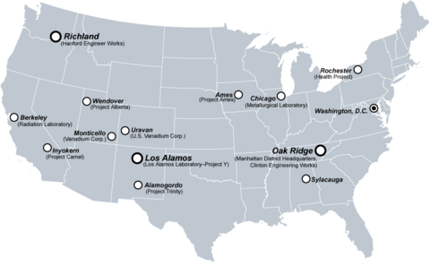
The Vanadium Corporation of America (VCA) began building a vanadium processing plant in Monticello in 1941. This was because of the high demand for radioactive materials during World War II. By 1943, VCA was producing a special material for the Manhattan Project, which was a secret project to build the first atomic bombs. The plant employed 200 workers until it closed in 1946. In 1948, the U.S. government bought the plant and reopened it in 1949 to process uranium and vanadium.
Monticello and the San Juan County area grew a lot during the "uranium boom" of the 1950s. The uranium mines in San Juan County were some of the richest in the country. The Happy Jack Mine, located in White Canyon, was the second richest source of high-quality uranium ore in the nation. During these years, the plant in Monticello processed huge amounts of ore from nearby canyons. The city's population more than doubled because of the plant and mining.
The demand for uranium decreased in the early 1960s. On January 1, 1960, the plant was permanently closed. The leftover materials were made safe by 1962, and the plant was taken apart in 1964.
A large cleanup project was done by the U.S. Department of Energy from 1989 to 2004. The goal was to remove any remaining radioactive material from the land and buildings. All radioactive material was moved to a special storage area near Monticello. Money was provided to restore the old plant site and about 150 acres of surrounding land. The city of Monticello helped reseed and restore the land. After the work was done, the city received about $7 million from the government.
With some of the cleanup money, the city decided to make its 9-hole golf course into an 18-hole course. The golf course is right next to the old plant site. A local resident, Rex Jensen, gave land to the city for the expansion. The new course was finished in 2001.
To help ensure the health of residents, a program was started in 2009. This program offers free health screenings to people who lived in Monticello between 1941 and 2000.
Geography and Climate
Monticello is located in the Four Corners area of the Colorado Plateau. This means it's near where the borders of Utah, Colorado, New Mexico, and Arizona meet.
The city covers about 3.66 square miles (9.49 km2) of land, making it the largest city in the county by area.
Monticello sits at the base of the Abajo Mountains, also known as the Blue Mountains. These mountains are part of the Manti-La Sal National Forest. Monticello's elevation is about 7,069 feet (2,155 meters) above sea level. From anywhere in town, you can see a group of trees on the Blue Mountains that looks like a horse's head and neck.
Monticello is also close to some amazing national parks. It's about 40 miles from the Needles District of Canyonlands National Park and 59 miles from Arches National Park, which is near Moab.
Monticello's Climate
Monticello has a climate similar to other high-altitude places in the western United States, like Flagstaff, Arizona. It has warm summers and cold, snowy winters.
| Climate data for Monticello, Utah, 1991–2020 normals, extremes 1902–2011 | |||||||||||||
|---|---|---|---|---|---|---|---|---|---|---|---|---|---|
| Month | Jan | Feb | Mar | Apr | May | Jun | Jul | Aug | Sep | Oct | Nov | Dec | Year |
| Record high °F (°C) | 57 (14) |
80 (27) |
81 (27) |
80 (27) |
91 (33) |
97 (36) |
97 (36) |
101 (38) |
91 (33) |
86 (30) |
70 (21) |
69 (21) |
101 (38) |
| Mean maximum °F (°C) | 47.6 (8.7) |
52.1 (11.2) |
63.1 (17.3) |
72.0 (22.2) |
80.6 (27.0) |
88.9 (31.6) |
92.1 (33.4) |
88.5 (31.4) |
83.8 (28.8) |
73.2 (22.9) |
60.7 (15.9) |
49.7 (9.8) |
92.6 (33.7) |
| Mean daily maximum °F (°C) | 36.3 (2.4) |
40.5 (4.7) |
50.4 (10.2) |
59.0 (15.0) |
69.1 (20.6) |
80.8 (27.1) |
85.3 (29.6) |
82.1 (27.8) |
75.0 (23.9) |
61.5 (16.4) |
48.1 (8.9) |
36.0 (2.2) |
60.3 (15.7) |
| Daily mean °F (°C) | 25.7 (−3.5) |
30.1 (−1.1) |
38.0 (3.3) |
45.1 (7.3) |
54.0 (12.2) |
63.8 (17.7) |
69.5 (20.8) |
67.5 (19.7) |
59.8 (15.4) |
47.6 (8.7) |
35.9 (2.2) |
26.1 (−3.3) |
46.9 (8.3) |
| Mean daily minimum °F (°C) | 15.2 (−9.3) |
19.6 (−6.9) |
25.6 (−3.6) |
31.3 (−0.4) |
38.8 (3.8) |
46.9 (8.3) |
53.6 (12.0) |
52.9 (11.6) |
44.7 (7.1) |
33.7 (0.9) |
23.7 (−4.6) |
16.2 (−8.8) |
33.5 (0.8) |
| Mean minimum °F (°C) | −2.8 (−19.3) |
1.1 (−17.2) |
9.4 (−12.6) |
18.8 (−7.3) |
25.0 (−3.9) |
33.9 (1.1) |
43.6 (6.4) |
43.2 (6.2) |
31.0 (−0.6) |
20.3 (−6.5) |
6.3 (−14.3) |
−2.5 (−19.2) |
−7.5 (−21.9) |
| Record low °F (°C) | −18 (−28) |
−21 (−29) |
−9 (−23) |
4 (−16) |
10 (−12) |
27 (−3) |
33 (1) |
25 (−4) |
22 (−6) |
5 (−15) |
−8 (−22) |
−22 (−30) |
−22 (−30) |
| Average precipitation inches (mm) | 1.57 (40) |
1.48 (38) |
1.09 (28) |
0.88 (22) |
0.89 (23) |
0.51 (13) |
1.36 (35) |
1.80 (46) |
1.67 (42) |
1.32 (34) |
1.19 (30) |
1.34 (34) |
15.10 (384) |
| Average snowfall inches (cm) | 13.4 (34) |
13.5 (34) |
7.4 (19) |
6.1 (15) |
1.1 (2.8) |
0.1 (0.25) |
0.0 (0.0) |
0.0 (0.0) |
0.1 (0.25) |
1.3 (3.3) |
7.3 (19) |
13.9 (35) |
64.2 (162.6) |
| Average extreme snow depth inches (cm) | 11.6 (29) |
10.5 (27) |
5.9 (15) |
0.8 (2.0) |
0.2 (0.51) |
0.0 (0.0) |
0.0 (0.0) |
0.0 (0.0) |
0.0 (0.0) |
0.4 (1.0) |
4.1 (10) |
8.6 (22) |
16.1 (41) |
| Average precipitation days (≥ 0.01 in) | 6.3 | 6.4 | 5.8 | 5.5 | 5.4 | 4.1 | 7.5 | 9.9 | 7.7 | 6.6 | 5.3 | 5.7 | 76.2 |
| Average snowy days (≥ 0.1 in) | 5.5 | 4.7 | 3.5 | 2.4 | 0.5 | 0.1 | 0.0 | 0.0 | 0.0 | 0.8 | 2.4 | 4.6 | 24.5 |
| Source 1: NOAA | |||||||||||||
| Source 2: XMACIS2 | |||||||||||||
People of Monticello
| Historical population | |||
|---|---|---|---|
| Census | Pop. | %± | |
| 1890 | 115 | — | |
| 1900 | 180 | 56.5% | |
| 1910 | 375 | 108.3% | |
| 1920 | 768 | 104.8% | |
| 1930 | 496 | −35.4% | |
| 1940 | 667 | 34.5% | |
| 1950 | 1,172 | 75.7% | |
| 1960 | 1,845 | 57.4% | |
| 1970 | 1,431 | −22.4% | |
| 1980 | 1,929 | 34.8% | |
| 1990 | 1,806 | −6.4% | |
| 2000 | 1,958 | 8.4% | |
| 2010 | 1,972 | 0.7% | |
| 2019 (est.) | 1,969 | −0.2% | |
| U.S. Decennial Census | |||
In 2000, Monticello had 1,958 people living in 606 households. About 41.9% of these households had children under 18. Most households (69.0%) were married couples.
The population was spread out by age. About 36.5% were under 18, and 12.3% were 65 or older. The average age was 30 years old. For every 100 females, there were about 110 males.
Culture and Events
As the main city of San Juan County, Monticello hosts the annual San Juan County Fair. This fun event usually happens in August. The city also holds a parade and celebration on July 24th for Pioneer Day. This Utah holiday remembers when Mormon settlers first arrived in the Salt Lake Valley.
Blue Mountain Entertainment is a local group that helps bring cultural shows and performances to Monticello throughout the year.
Monticello also hosts the Blue Mountain Triathlon every year. This challenging race includes cross-country skiing, an 18-mile bike ride, and a 5-mile run that goes past Newspaper Rock.
On October 4, 1997, Gordon B. Hinckley, the leader of The Church of Jesus Christ of Latter-day Saints, announced plans to build smaller temples. The first of these "miniature temples" was built in Monticello. Construction began on November 17, 1997. The Monticello Utah Temple was dedicated on July 26, 1998. It was later made bigger and rededicated on November 17, 2002. This temple was the 53rd one completed by the church.
Education in Monticello
The San Juan School District runs two public schools in Monticello. Monticello Elementary School teaches children from kindergarten to 6th grade. Older students, from 7th to 12th grade, go to Monticello High School. The San Juan County Library is also located in Monticello, offering books and resources for everyone.
An extension of the George Wythe University was planned for Monticello, with construction starting in August 2008. However, this project was never finished.
Fun and Recreation
Monticello is home to The Hideout Golf Club, an 18-hole golf course. It was built near the cleaned-up site of the old uranium plant. The Hideout is known as one of the best golf courses in Utah and one of the top municipal courses in the U.S.
The nearby Abajo Mountains and surrounding areas are great for outdoor activities. You can go hiking and hunting in the mountains. If you enjoy fishing, there are several lakes on the Blue Mountains, including Foy Lake, Monticello Lake, and Lloyds Lake.
See also
 In Spanish: Monticello (Utah) para niños
 | James B. Knighten |
 | Azellia White |
 | Willa Brown |


