
Paradox Valley facts for kids
Quick facts for kids Paradox Valley |
|
|---|---|

Paradox Valley as seen from near the southwest rim. The Dolores River is at the left edge.
|
|

Paradox Valley
Location in Colorado
|
|
| Floor elevation | 4,944 ft (1,507 m) |
| Length | 25 miles (40 km) NW-SE |
| Width | 3 to 5 miles (4.8 to 8.0 km) |
| Geography | |
| Location | Montrose County, Colorado, United States |
Paradox Valley is a unique valley found in Montrose County, Colorado, in the United States. It's a dry area with not many people living there. The valley gets its name because of the Dolores River. Instead of flowing along the valley, the river cuts right across its middle! This seems like a "paradox," or something that doesn't make sense.
This valley is also home to a special project. It helps control the amount of salt in the Colorado River. This project has caused many small earthquakes. For a while, there were also plans to build a new uranium processing plant here.
Contents
What is Paradox Valley Like?
Paradox Valley stretches from the northwest to the southeast. It is about 3 to 5 miles (4.8 to 8.0 km) wide and 25 miles (40 km) long. You can find it on the far western edge of Colorado. It's about 50 miles (80 km) south of a city called Grand Junction. The La Sal Mountains in Utah are to the northwest.
Colorado State Highway 90 goes through Paradox Valley. It connects Naturita to the Utah state line. The highway crosses the old Dolores River Bridge near a small town called Bedrock. Another town, Paradox, is a few miles north of the highway.
How High is the Valley?
The lowest parts of the valley floor are about 5,000 feet (1,500 m) high near the Dolores River. The highest parts, at the southeast end, are almost 6,000 feet (1,800 m) high. The valley is surrounded by steep walls made of sandstone and shale.
Why is the River's Path So Strange?
A geologist named Albert Charles Peale named the valley in 1875. He noticed the Dolores River did "strange and unexpected things." The river enters the valley through a narrow gap in one wall. Then, it flows straight across the middle. Finally, it leaves through another gap in the opposite wall.
Because of this unusual path, it's hard to use the Dolores River for irrigation in the valley. But, there are springs and streams. These are fed by snow melting from the La Sal Mountains. They help support farming in the northwestern part of the valley.
Weather in Paradox Valley
The town of Bedrock is in the center of the valley. In December, the average high temperature is about 45 °F (7 °C). In July, it can reach 96 °F (36 °C). Low temperatures range from 13 °F (−11 °C) in December to 54 °F (12 °C) in July. The valley gets about 11 inches (28 cm) of rain each year. This includes about 9 inches (23 cm) of snow.
How Paradox Valley Formed

The strange path of the Dolores River can be explained by how the valley formed. Paradox Valley is a collapsed anticline. An anticline is a type of geological fold in rock layers.
About 300 million years ago, during the Pennsylvanian period, there was a lot of pressure on the land to the northeast. This pressure caused deep layers of salt to move. The salt flowed towards where Paradox Valley is today. It hit a buried ridge of rock and was pushed upwards. This created a salt dome under the surface.
Over a very long time (about 150 million years), groundwater seeped into the top of this salt dome. It dissolved the salt layers underneath. This caused the center of the dome to collapse. This collapse formed what we now call Paradox Valley. The Dolores River was already flowing in this area. As the land slowly collapsed, the river kept cutting deeper into the ground, keeping its original path. A similar process created the Moab Valley in Utah. The Colorado River also cuts across that valley in a similar way.
What is the Paradox Formation?
The Paradox Formation is a special layer of rock. It contains salt, gypsum, anhydrite, shale, sandstone, and limestone. This formation is named after the rocks found in Paradox Valley. The larger Paradox Basin, where this formation is found, also gets its name from the valley.
History of Paradox Valley
The Ute people lived in Paradox Valley for a long time. In 1868, a treaty created a reservation for the Utes. This included much of western Colorado, like Paradox Valley. However, people started bringing their cattle to graze in the valley in 1877. This was against the treaty.
By 1881, the Utes were forced to leave the area. In 1882, the United States Congress officially opened the land for new settlers. The springs and streams helped people farm in the northwest part of the valley. In the mid-1890s, copper was found near the town of Bedrock. This brought even more settlers to the area.
Mining in the Valley
The valley and the surrounding plateau became important for radioactive materials. These included radium and uranium. In 1913, The New York Times reported that mines near Paradox Valley had "the greatest radium ore deposits in the world." Radium production stopped in 1922 when richer deposits were found elsewhere. But, uranium and vanadium continued to be mined for most of the century.
The Paradox Valley Unit

Very thick layers of salt (up to 14,000 feet (4,300 m) thick) are still under Paradox Valley. The Dolores River naturally picks up a lot of salt as it flows through the valley. It can pick up about 100,000 to 200,000 tons of salt each year.
In the 1980s, the United States Bureau of Reclamation started building a pumping facility. This facility is called the Paradox Valley Unit (PVU). It is part of a bigger project to control salt in the Colorado River Basin. The PVU started working fully in 1996. It collects salty water from 12 shallow wells along the Dolores River.
The system then mixes this salty water with fresh water and a special chemical. This mixture is pumped into a deep injection well. It goes 14,000 to 16,000 feet (4,300 to 4,900 m) deep into ancient rocks. A study in 2001 found that the total salt reaching the Dolores River had dropped by about 90%. As of 2009, the PVU removes about 113,000 tons of salt from Paradox Valley every year.
Earthquakes Caused by the Project
The injection well of the Paradox Valley Unit has caused thousands of earthquakes. By 2001, at least 4,000 small tremors had occurred. Most of these were too small for people to feel. But, at least 15 of them were strong enough to be noticed. The largest was a 4.3 magnitude quake on May 27, 2000. The PVU stopped operations for 28 days after this quake. Later, they started injecting water again, but at a slower rate. Other earthquakes have also been linked to the project, including a 3.9 magnitude quake in 2004.
Piñon Ridge Mill Project
In 2009, a company called Energy Fuels Resources Corporation suggested building a uranium processing plant. It would have been located at the southeast end of Paradox Valley. This plant, called the Piñon Ridge Mill, could have processed 500 tons of uranium ore every day. Legal challenges delayed the project for many years. As of September 2020, it seems the project will not be built.
Images for kids
-
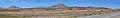
South end of the Paradox Valley
-
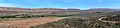
North end of the Paradox Valley
See also
 In Spanish: Paradox Valley para niños
