Cortez, Colorado facts for kids
Quick facts for kids
Cortez, Colorado
|
|
|---|---|

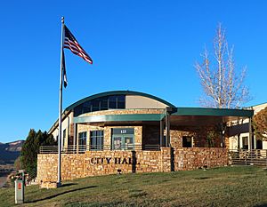
Cortez city hall, built in 2017.
|
|

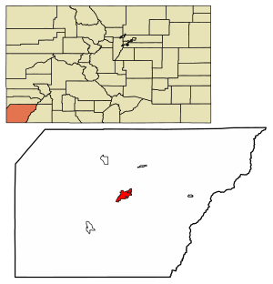
Location of the City of Cortez in Montezuma County, Colorado.
|
|
| Country | |
| State | |
| County | Montezuma County seat |
| Government | |
| • Type | Home rule municipality |
| Area | |
| • Total | 6.274 sq mi (16.249 km2) |
| • Land | 6.230 sq mi (16.136 km2) |
| • Water | 0.044 sq mi (0.113 km2) |
| Elevation | 6,181 ft (1,884 m) |
| Population
(2020)
|
|
| • Total | 8,766 |
| • Density | 1,407/sq mi (543/km2) |
| Time zone | UTC−07:00 (MST) |
| • Summer (DST) | UTC−06:00 (MDT) |
| ZIP Code |
81321
|
| Area code(s) | 970 |
| FIPS code | 08-17375 |
| GNIS feature ID | 2410236 |
| Website | City of Cortez |
Cortez is a town in Colorado, United States. It's the main town and the biggest one in Montezuma County. In 2020, about 8,766 people lived there. Cortez is called a "home rule municipality," which means it has its own local government rules. It's also the "county seat," meaning it's where the county government offices are located.
Contents
History of Cortez
Cortez was started in 1886. It was built to house the workers who were digging tunnels and irrigation ditches. These projects helped bring water from the Dolores River to the Montezuma Valley. The town got its name from Hernán Cortés, a famous Spanish explorer.
Today, Cortez is a popular spot for tourists. Many people stay here because it's close to cool places like Mesa Verde National Park, Monument Valley, and the Four Corners.
Ancient Sites Near Cortez
The area around Cortez has many amazing ancient sites. These places are listed on special registers because they are historically important. Some of the big ones include:
- Crow Canyon Archaeological Center
- Canyon of the Ancients National Monument
- Hovenweep National Monument
- Mesa Verde National Park
There are also smaller, unique sites like Lowry Ruin and Yucca House National Monument. These sites show how people lived long ago.
Historic Trails and Roads
Several important trails and scenic roads pass through the Cortez area:
- Old Spanish National Historic Trail
- San Juan Skyway National Scenic Byway
- Trail of the Ancients
U-2 Plane's Emergency Landing in 1959
On August 3, 1959, a Lockheed U-2 spy plane had to make an emergency landing at the Cortez Municipal Airport. The pilot, Major Hsi-Chun Mike Hua, was on a training flight when his engine stopped working high in the sky. He managed to guide the plane through a valley and found the airport, which was lit up at night. It was the only airport in the area with a runway lit up all night.
Geography and Climate
In 2020, Cortez covered an area of about 16.2 square kilometers (about 6.3 square miles). A small part of this area is water.
Cortez Weather
Cortez has a climate with hot summers and cold winters. This is because it's located at a high elevation. It's known for having dry summers.
| Climate data for Cortez, Colorado, 1991–2020 normals, extremes 1911–present | |||||||||||||
|---|---|---|---|---|---|---|---|---|---|---|---|---|---|
| Month | Jan | Feb | Mar | Apr | May | Jun | Jul | Aug | Sep | Oct | Nov | Dec | Year |
| Record high °F (°C) | 63 (17) |
79 (26) |
80 (27) |
88 (31) |
95 (35) |
102 (39) |
102 (39) |
99 (37) |
99 (37) |
88 (31) |
75 (24) |
65 (18) |
102 (39) |
| Mean maximum °F (°C) | 54.3 (12.4) |
59.8 (15.4) |
69.8 (21.0) |
77.4 (25.2) |
86.3 (30.2) |
94.2 (34.6) |
98.0 (36.7) |
94.6 (34.8) |
90.0 (32.2) |
80.5 (26.9) |
67.6 (19.8) |
56.6 (13.7) |
98.3 (36.8) |
| Mean daily maximum °F (°C) | 42.9 (6.1) |
47.2 (8.4) |
56.0 (13.3) |
63.5 (17.5) |
73.4 (23.0) |
85.3 (29.6) |
90.5 (32.5) |
87.7 (30.9) |
80.1 (26.7) |
67.4 (19.7) |
54.1 (12.3) |
43.2 (6.2) |
65.9 (18.8) |
| Daily mean °F (°C) | 29.7 (−1.3) |
34.4 (1.3) |
41.8 (5.4) |
48.2 (9.0) |
57.3 (14.1) |
67.3 (19.6) |
73.8 (23.2) |
71.7 (22.1) |
63.8 (17.7) |
51.5 (10.8) |
39.9 (4.4) |
30.4 (−0.9) |
50.8 (10.5) |
| Mean daily minimum °F (°C) | 16.6 (−8.6) |
21.5 (−5.8) |
27.6 (−2.4) |
32.9 (0.5) |
41.3 (5.2) |
49.4 (9.7) |
57.2 (14.0) |
55.8 (13.2) |
47.5 (8.6) |
35.5 (1.9) |
25.8 (−3.4) |
17.7 (−7.9) |
35.7 (2.1) |
| Mean minimum °F (°C) | −1.0 (−18.3) |
4.0 (−15.6) |
13.9 (−10.1) |
20.5 (−6.4) |
27.9 (−2.3) |
37.3 (2.9) |
47.6 (8.7) |
47.2 (8.4) |
34.1 (1.2) |
21.3 (−5.9) |
10.5 (−11.9) |
0.3 (−17.6) |
−4.3 (−20.2) |
| Record low °F (°C) | −27 (−33) |
−31 (−35) |
−7 (−22) |
6 (−14) |
15 (−9) |
27 (−3) |
31 (−1) |
30 (−1) |
23 (−5) |
7 (−14) |
−14 (−26) |
−22 (−30) |
−31 (−35) |
| Average precipitation inches (mm) | 1.06 (27) |
0.96 (24) |
0.86 (22) |
0.72 (18) |
0.93 (24) |
0.37 (9.4) |
1.25 (32) |
1.34 (34) |
1.48 (38) |
1.08 (27) |
0.85 (22) |
0.89 (23) |
11.79 (300.4) |
| Average snowfall inches (cm) | 8.0 (20) |
7.2 (18) |
5.0 (13) |
2.2 (5.6) |
0.3 (0.76) |
0.0 (0.0) |
0.0 (0.0) |
0.0 (0.0) |
0.0 (0.0) |
0.6 (1.5) |
2.7 (6.9) |
7.4 (19) |
33.4 (84.76) |
| Average extreme snow depth inches (cm) | 5.1 (13) |
4.1 (10) |
1.6 (4.1) |
0.7 (1.8) |
0.0 (0.0) |
0.0 (0.0) |
0.0 (0.0) |
0.0 (0.0) |
0.0 (0.0) |
0.3 (0.76) |
1.3 (3.3) |
3.8 (9.7) |
6.6 (17) |
| Average precipitation days (≥ 0.01 in) | 6.7 | 7.0 | 6.1 | 5.4 | 6.0 | 2.8 | 7.4 | 8.4 | 6.9 | 5.5 | 5.0 | 7.2 | 74.4 |
| Average snowy days (≥ 0.1 in) | 5.8 | 4.6 | 3.6 | 1.9 | 0.4 | 0.0 | 0.0 | 0.0 | 0.0 | 0.5 | 1.9 | 5.1 | 23.8 |
| Source 1: NOAA | |||||||||||||
| Source 2: National Weather Service | |||||||||||||
Population of Cortez
| Historical population | |||
|---|---|---|---|
| Census | Pop. | %± | |
| 1890 | 332 | — | |
| 1900 | 125 | −62.3% | |
| 1910 | 565 | 352.0% | |
| 1920 | 541 | −4.2% | |
| 1930 | 921 | 70.2% | |
| 1940 | 1,778 | 93.1% | |
| 1950 | 2,680 | 50.7% | |
| 1960 | 6,764 | 152.4% | |
| 1970 | 6,032 | −10.8% | |
| 1980 | 7,095 | 17.6% | |
| 1990 | 7,284 | 2.7% | |
| 2000 | 7,977 | 9.5% | |
| 2010 | 8,482 | 6.3% | |
| 2020 | 8,766 | 3.3% | |
| U.S. Decennial Census | |||
In 2010, there were 8,482 people living in Cortez. There were about 3,590 households. The city had a mix of people, including White, Native American, and Hispanic or Latino residents. The average age in Cortez was 36 years old.
Economy in Cortez
Cortez is an important business center for the area. People from nearby parts of Utah, Arizona, and New Mexico come to Cortez to shop. The city's economy relies a lot on tourism. Many visitors come to see Mesa Verde National Park and other natural areas. These include San Juan National Forest and Canyons of the Ancients National Monument. The lands of the Ute Mountain Ute Tribe and Navajo Nation also bring visitors.
Mesa Verde National Park, famous for its Ancestral Pueblo cliff dwellings, is located southeast of Cortez.
Cortez is also home to the main office of Osprey Packs. This company makes backpacks and other gear, and it employs over 100 people in Cortez.
Education
The schools in Cortez are part of the Montezuma-Cortez School District RE-1. The district has a preschool, several elementary schools, one middle school, and one high school.
The schools in Cortez include:
- Montezuma-Cortez RE-1 Pre-School
- Kemper Elementary School
- Lewis-Arriola Elementary School
- Manaugh Elementary School
- Mesa Elementary Schools
- Pleasant View Elementary School
- Cortez Middle School
- Montezuma-Cortez High School
The mascot for Montezuma-Cortez High School is the Panther.
Transportation
The Cortez Municipal Airport serves the city. Cortez is also part of Colorado's Bustang bus system. It is a stop on the Durango-Grand Junction Outrider bus line.
Notable People
Here are some well-known people from Cortez:
- William B. Ebbert, a rancher and politician.
- Vince Lee, an architect and climber.
- Michael Milenski, who founded the Long Beach Opera.
- Chuck Nevitt, a former NBA basketball player.
- Scott Tipton, a former U.S. Representative.
- Eli Tomac, a professional dirt bike racer.
See also
 In Spanish: Cortez (Colorado) para niños
 | William Lucy |
 | Charles Hayes |
 | Cleveland Robinson |


