
Canyons of the Ancients National Monument facts for kids
Quick facts for kids Canyons of the Ancients National Monument |
|
|---|---|
 |
|

Canyons of the Ancients National Monument
Location in Colorado

Canyons of the Ancients National Monument
Location in the United States
|
|
| Location | Montezuma and Dolores counties, Colorado, United States |
| Nearest city | Cortez, CO |
| Area | 176,056 acres (71,247 ha) |
| Established | June 9, 2000 |
| Governing body | U.S. Bureau of Land Management |
| Website | Canyons of the Ancients National Monument |
Canyons of the Ancients National Monument is a special place in southwestern Colorado. It protects an amazing landscape filled with ancient archaeological sites. The monument covers about 176,056 acres. It is managed by the Bureau of Land Management. This monument was created on June 9, 2000, to protect the largest collection of ancient sites in the United States. Most of these sites are Ancestral Puebloan ruins. By 2005, over 6,000 different archaeological sites had been found here.
Where is Canyons of the Ancients?
Canyons of the Ancients National Monument is in southwestern Colorado. It is about 9 miles west of Pleasant View, Colorado. The monument's northern and eastern sides are marked by canyons. The western side is the border with Utah. To the south, it borders the Ute Mountain Reservation and McElmo Creek.
Who lived here long ago?

Early Pueblo People: AD 750 to 1100
Ancient Pueblo people lived in the Canyons of the Ancients area around the 10th century. For example, Lowry Pueblo was built on top of older pit-houses from the 10th century.
During this time, Pueblo people built homes with stone. They often faced windows south to catch the sun. Their buildings were often shaped like U, E, or L. Towers were built near special underground rooms called kivas. These towers might have been used as lookouts.
Pottery became more varied. People made pitchers, bowls, and jars for food and drink. They started making white pottery with black designs from plants. They also learned how to manage water. They built reservoirs and dams to save water and control floods.
Great Pueblo Period: AD 1100 to 1300
Around AD 1090, Pueblo people started building bigger villages. They often built them on top of older pit-houses. Lowry Pueblo started small with a few rooms and two kivas in 1090. It grew twice, around 1103 and 1120. Eventually, it had 40 rooms, 8 kivas, and one large community kiva.
Like their neighbors at Hovenweep National Monument and Mesa Verde National Park, the people at Lowry Pueblo were farmers and hunters. They grew beans, corn, and squash. They also raised turkeys. They were skilled at making and decorating pottery.
What are the important ancient sites?
More than 20,000 ancient sites have been found in the monument. In some areas, there are over 100 sites per square mile! Most of these stone buildings are from the Ancient Puebloans.
After building simple pit-houses, the Puebloans later built villages with cliff dwellings. Other ancient ruins include Sweat lodges, kivas, shrines, and petroglyphs (rock carvings). They also built reservoirs with stone and earth dams. These dams had spillways to control water during floods. Many small check dams were also built. Stone towers are found all over the monument. They might have been used as lookout posts.
| Pueblo | Photo | What's special about it? |
|---|---|---|
| Lowry Pueblo |  |
Lowry Pueblo is a National Historic Landmark. It has 8 kivas, a large community kiva, and 40 rooms. Some rooms were three stories high. The large underground kiva was built around 1103 AD. It had murals painted on its walls. This large kiva suggests Lowry Pueblo was an important place for religious gatherings. |
| Painted Hand Pueblo |  |
Painted Hand Pueblo is a site in the backcountry. It has unexcavated ruins built on boulders along a cliff. There is also a standing tower. The pueblo got its name from a boulder with ancient paintings of hands. |
| Sand Canyon Pueblo | 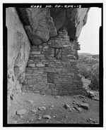 |
Sand Canyon Pueblo was one of the largest pueblos in the 13th century. It was built between 1250 and 1280. It had at least 20 family room blocks with 420 rooms, 90 kivas, and 14 towers. A spring runs through the center of this walled site. Up to 725 people may have lived here. Families lived in groups of rooms with their own kivas. The community shared plazas and large kivas. By 1280, people started moving away from the pueblo. |
Why did people leave?
It seems the people of Canyons of the Ancients left their homes earlier than others in the area. They moved away around the mid-12th century. Some items found here show a connection to the Chacoan culture. Others are similar to those from Mesa Verde.
Many Ancient Pueblo people from this region moved south. They went to areas in Arizona and New Mexico. Today's Pueblo people, like the Hopi and Zuni, are their descendants. Modern Pueblo people live on reservations. Most are in New Mexico, but some are in Arizona. About 60,000 Pueblo people live in three main areas:
- along the upper Rio Grande in New Mexico, like Taos Pueblo
- southern New Mexico, including Zuni, Acoma, Laguna, and Isleta pueblos
- Arizona Hopi.
Later Native American Tribes: 14th to 18th Century
After 1300, hunter-gatherers moved into southwestern Colorado and southeastern Utah. These were the ancestors of the Ute and Navajo tribes.
- The Navajo ancestors came from Alaska and northwestern Canada. They likely traveled through the Great Basin. They were in this area after AD 1300, and definitely by the early 16th century.
- The Ute ancestors arrived from the west between 1300 and the 18th century. They were hunter-gatherers who moved east from southern California. They hunted and gathered across a large area, including the canyons and mountains of eastern Utah and Colorado.
During this time, Spanish explorers and settlers arrived in northern New Mexico in the 16th century. They brought new things like guns and horses. They also brought new diseases and shared their culture, religion, and government ideas. In the 18th century, Spanish missionaries explored the area. They were looking for a route to Spanish missions in California. Two Spanish friars, Silvestre Vélez de Escalante and Francisco Atanasio Domínguez, traveled through western Colorado to Utah.
European and American Settlers: 19th Century to Today
The first Anglo American people arrived in the early 1800s. They were mostly trappers. Later in the 1800s, people found valuable metals here. Miners and other settlers moved into the region. By the mid-1800s, the United States government and Native American tribes had disagreements over land. Native American people were forced to leave their homelands. The Navajo moved south. The Ute territory became much smaller.
How are the ruins cared for?
Lowry Pueblo was first dug up in 1928. It was restored in 1965. Two years later, it was named a National Historic Landmark. It was also added to the National Register of Historic Places.
Canyons of the Ancients National Monument Today

The Bureau of Land Management manages the monument. They make sure to protect the ancient sites and natural resources. The monument was created in 2000 to protect its archaeological, natural, and geological features. At Lowry Pueblo, you can find parking, a picnic area, a toilet, and a trail. Sand Canyon Pueblo also has a trail that leads to McElmo Canyon.
Bruce Babbitt, a former Secretary of the Interior, said that Canyons of the Ancients was special. Unlike other monuments that only protected major ruins, this one protected the entire landscape. This included places where ancient people lived, hunted, farmed, and held religious ceremonies.
Wilderness Study Areas
There are three special Wilderness study areas within the monument:
- Cahone Canyon: This area is about 9,156 acres. It has three canyons with pine and juniper trees. It also has areas with water and sagebrush.
- Cross Canyon: This area is about 12,721 acres. About 1,008 acres of it cross into Utah. It also has three canyons (Cross, Ruin, and Cow) with pine and juniper trees, and other plant life.
- Squaw/Papoose Canyon: This area is about 11,357 acres. About 6,676 acres cross into Utah. It has two canyons, Squaw and Papoose.
Anasazi Heritage Center and Visitor Center

The Anasazi Heritage Center is also the visitor center for Canyons of the Ancients National Monument. It has artifacts from the monument. There is a museum with interactive exhibits, a library, and a theater. You can learn about the Ancient Puebloan culture, the Trail of the Ancients Byway, and the monument itself.
Protecting the Sites
It's hard to stop vandalism and treasure hunting at the monument. There are not enough staff to watch over all the sites. Many ancient artifacts have been taken from the monument. They are now in private collections. In 2006, a news report said that funding for the monument had dropped. There was a serious looting event in January 2006.
What about the natural environment?
Geology and Landscape
The northern part of the monument has gentle slopes. The land ranges from about 6,700 feet in the east to 5,500 feet in the west. These areas are made of sedimentary rocks from the Cretaceous period. These rocks are mostly covered by younger gravel and sand. The region has canyons that drain south and west into McElmo Creek. The oldest rocks are found in McElmo Canyon. These are sedimentary layers from the Jurassic period.
Rocks from the Cretaceous and Jurassic Periods
The rocks in the monument tell a long story. They are over 1,500 feet thick.
| Time Period | Rock Layer | What is it made of? | How thick is it? | Interesting facts |
|---|---|---|---|---|
| Cretaceous (145.5–66 million years ago) | Dakota Sandstone | Mostly sandstone, with some gravel and thin layers of shale and coal. | 100 feet (30 m) | Formed about 95 million years ago. Ancient tools were made from chert found in this rock. |
| Burro Canyon Formation | Mostly sandstone, siltstone, and mudstone. Formed from ancient rivers. | 100 feet (30 m), but varies a lot. | Hardened sandstone from this layer was used to make tools. | |
| Jurassic (199.6–145.5 million years ago) | Morrison Formation | Mostly siltstone and sandstone from ancient rivers and lakes. Some layers are from volcanic ash. | 600 feet (180 m) | Elsewhere, many large dinosaur fossils have been found in this formation. |
| Bluff Sandstone | Formed from huge ancient sand dunes. | 250 feet (76 m) | Well-preserved dinosaur tracks have been found in rocks from this layer. | |
| Summerville Formation | Mostly siltstone and sandstone. | 100 feet (30 m) | ||
| Entrada Sandstone | About 30 feet of red siltstone, then about 80 feet of sandstone. | 110 feet (34 m) | Many cliff dwellings and other structures are found in caves within this sandstone. | |
| Navajo Sandstone | Formed from wind-blown sand. | 100 feet (30 m) | The trail at Sand Canyon near McElmo Creek starts on rocks from this layer. | |
| Kayenta Formation | Sandstone formed from ancient streams. | 20 to 30 feet (6.1 to 9.1 m) | ||
| Wingate Sandstone | Formed from wind-blown sand. | At least 170 feet (52 m) | It was deposited about 190 million years ago. |
Carbon Dioxide Deposits
Carbon dioxide gas is found deep underground in rocks from the Mississippian age (about 359–299 million years ago). This area has one of the largest carbon dioxide deposits in the United States. The gas is used to help get more oil out of the ground. Scientists have also studied this area to see if carbon dioxide could be stored underground to help the environment.
Oil and Gas Exploration
In 1986, the area was named the Anasazi Area of Critical Environmental Concern. This was to make sure there would be no new oil and gas leases that could harm the area. Only leases that help protect oil and gas resources are allowed.
In 2000, 85% of the monument was leased for ranching and oil and gas exploration. Only 2,000 acres were not leased. This land is home to ancient sites and wildlife. Some environmental groups have worked to stop more oil and gas exploration. They worry that new roads and vehicles for oil and gas work could damage archaeological areas.
Ken Salazar, a former Secretary of Interior, said in 2009: "Canyons of the Ancients National Monument shows a new way of managing land. After 130 years of research, we know that Canyons of the Ancients has tens of thousands of important archaeological sites. It represents the best of our cultural heritage. With volunteers and careful management, this special place protects ancient homes and landscapes for Native American citizens and for children across the United States."
Wildlife in the Monument
The monument is home to many desert animals. You might see American kestrels, Gambel's quail, Golden eagles, and Peregrine falcons. There are also different kinds of lizards and snakes. Mammals like jackrabbits, Mule deer, fox, muskrat, beaver, and bobcat live here.
However, building more roads and structures for oil and gas can threaten the homes of these animals and plants.
Images for kids
-

Kiva ruins
-
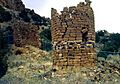
Stone towers are numerous in the monument


