
Summerville Formation facts for kids
Quick facts for kids Summerville FormationStratigraphic range: Oxfordian 161–151Ma |
|
|---|---|

Summerville Formation at the type locality at Summerville Point, east side of the San Rafael Swell, Emery County, Utah
|
|
| Type | Geological formation |
| Unit of | San Rafael Group |
| Sub-units | Bluff Sandstone |
| Underlies | Morrison Formation |
| Overlies | Todilto & Curtis Formations |
| Thickness | 100 m (330 ft) |
| Lithology | |
| Primary | Mudstone, sandstone |
| Other | Gypsum |
| Location | |
| Coordinates | 39°12′58″N 110°32′38″W / 39.216°N 110.544°W |
| Approximate paleocoordinates | 31°54′N 54°42′W / 31.9°N 54.7°W |
| Region | Four Corners, (Southwestern United States) |
| Country | |
| Extent | Henry Mountains, Paradox Basin |
| Type section | |
| Named for | Summerville Point, Emery County, Utah |
| Named by | James Gilluly & J.B. Reeside Jr. |
| Year defined | 1928 |
 Summerville Formation outcrops in Utah, Colorado and New Mexico |
|
The Summerville Formation is a special type of rock layer found in the Southwestern United States. You can see it in New Mexico, Colorado, and Utah. It formed a very long time ago, during the Late Jurassic period. This was about 161 to 151 million years ago.
Contents
What is the Summerville Formation?
This rock layer is mostly made of red mudstone, which is like hardened mud. It also has thin layers of green and red sandstone. The formation can be as thick as 100 meters (330 ft).
In the lower parts of the formation, you can find cracks shaped like polygons. These cracks formed when wet mud dried out a long time ago. The upper parts have a lot of gypsum, which is a mineral. This suggests the area was once a dry, salty flatland called a sabkha. This sabkha was next to an ancient ocean called the Sundance Sea.
You can see the Summerville Formation in places like the San Rafael Reef and the Waterpocket Fold. It also appears in the Henry Mountains and the Paradox Basin. In some areas, like the San Juan Basin, there is no gypsum. Also, some parts have conglomerate, which is rock made of pebbles cemented together.
How Does the Summerville Formation Connect to Other Rocks?
The Summerville Formation sits nicely on top of older rock layers. In Utah and western Colorado, it rests on the Curtis Formation. In New Mexico and southwest Colorado, it sits on the Todilto Formation.
However, there's a big gap in time between the Summerville Formation and the younger Morrison Formation above it. This gap is called an unconformity. In some spots, like near Moab and La Sal, the Summerville Formation is very thin. Here, it's only about 1.2 meters (3.9 feet) thick. It rests directly on the Entrada Sandstone.
Sometimes, layers of wind-blown sand, like the Bluff Sandstone, are found between the Summerville and Morrison formations. The Morrison Formation shows that the climate became wetter later on.
What Was the Environment Like?
Scientists believe the Summerville Formation formed as the ancient Sundance Sea slowly pulled back towards the north. At the same time, the basins where the Curtis and Todilto formations were forming also filled up.
This created a very flat landscape. Sometimes, during dry periods, wind would blow sand into the area. Then, waves in temporary salty lakes would spread this sand into thin layers.
What Fossils Are Found Here?
The Summerville Formation does not have many body fossils, like bones or shells. But it does have some cool trace fossils! These are signs of ancient life, like footprints.
Scientists have found tracks from theropod dinosaurs in Utah, New Mexico, and Colorado. Theropods were meat-eating dinosaurs, like the T-Rex!
Dinosaur Footprints and Other Traces
| Avemetatarsalian Traces in the Summerville Formation | ||||||
|---|---|---|---|---|---|---|
| Type of Trace | What it is | Where Found | Notes | |||
| Dystrophaeus | A type of long-necked dinosaur (eusauropodan) | Utah | Only a few bone pieces were found, like parts of a shoulder blade and arm bones. | |||
| Camarasaurus | A large, plant-eating dinosaur | New Mexico | Early findings were thought to be Camarasaurus, but later studies showed they were just general sauropod remains. | |||
| Pteraichnus | Pterosaur (flying reptile) footprints | Arizona, Colorado, Utah | These are tracks left by flying reptiles. Some tracks might actually be from the younger Morrison Formation. Many of these tracks are kept at the University of Colorado's Dinosaur Tracks Museum. | |||
How Was the Formation Discovered?
The Summerville Formation was first officially named in 1928. It was named after the rock layers seen in the San Rafael Reef. Similar rock layers in northeastern Arizona and the San Juan Basin are sometimes called the Wanakah Formation. However, in north-central New Mexico, these layers are still called the Summerville Formation.
Images for kids
-
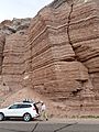
Summerville Formation west of Hansville, Utah
-
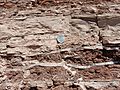
Summerville Formation with gypsum-filled cracks. U.S. quarter dollar for scale


