Ute Mountain facts for kids
Quick facts for kids Ute Peak |
|
|---|---|
| Ute Mountain | |

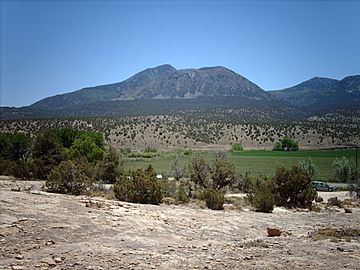
Ute Peak from the north.
|
|
| Highest point | |
| Elevation | 9,984 ft (3,043 m) |
| Prominence | 4,039 ft (1,231 m) |
| Isolation | 34.27 mi (55.15 km) |
| Listing | Colorado prominent summits Colorado range high points |
| Geography | |
| Location | Ute Mountain Ute Tribe Reservation, Montezuma County, Colorado, United States |
| Parent range | Ute Mountains |
| Topo map | USGS 7.5' topographic map Battle Rock, Colorado |
Ute Mountain is a special mountain in the southwestern part of Colorado. It's also called Ute Peak or Sleeping Ute Mountain. The Ute people have their own names for it: Wisuv Káruv in Ute and Dził Naajiní in Navajo. This mountain is part of a smaller group of mountains called the Ute Mountains. It sits on the northern edge of the Ute Mountain Ute Tribe Reservation, which is in the very southwest corner of Colorado.
People use a few different names for this mountain and the mountains around it. Sometimes the highest point is called Sleeping Ute Mountain. Other times, the whole group of mountains is seen as one big mountain called Sleeping Ute Mountain. You can find all these names on different maps and reports from the USGS.
The Ute Mountains look like a cluster of peaks, about 5 miles wide and 12 miles long. They stand alone, far from other mountains. Even though Ute Mountain is not as tall as Colorado's highest peaks, it's the eighth most important peak in the state because it stands out so much. It also rises sharply from the land around it, especially about 4,250 feet (1,295 meters) above the Montezuma Valley to the southeast.
The "Sleeping Ute" is said to look like a Ute Chief lying on his back with his arms crossed. The Weeminuche Ute band, an important group of the Ute people, thought these mountains were a sacred place. Today, their descendants, the Ute Mountain Ute Tribe, still consider it sacred. It's still used in their ceremonies, and you can even find a "Sundance Ground" marked on some maps between parts of the mountain called The Knees and Horse Peak.
Long ago, the northern part of the mountains was not part of the Ute reservation. But later, some land was traded near Mesa Verde National Park for federal land on the mountain. This allowed the reservation to grow north to McElmo Creek and include the entire mountain range. Because of this, it's hard for people from outside the tribe to visit the mountains for fun. There are not many roads or trails, though there are some radio towers and water tanks. A road from Towaoc along Cottonwood Wash almost reaches the top of Ute Peak.
Contents
Legend of the Sleeping Ute
A special Ute Indian story tells us about the Sleeping Ute. It says the mountain is a "Great Warrior God" or chief who fell asleep. He was resting and healing after a big battle with "the Evil Ones." You can find different versions of this legend.
What the Sleeping Ute Looks Like
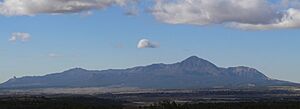
You can easily see the shape of the Sleeping Ute from many places, even up to 50 miles away. This includes places like the Four Corners Monument and parts of Mesa Verde National Park. The best view is from about 15 to 25 miles northeast of the mountains, as shown in the picture.
Here are some parts of the mountain that look like features of a sleeping person (from north to south):
- Head – The shape of Marble Mountain looks like a face. A feathered headdress can be seen tapering north from Black Mountain and Marble Mountain.
- Crossed Arms – Ute Peak is the highest and most eastern peak in the Ute Mountains, forming the arms.
- Ribcage – Horse Mountain to the east and the two peaks Black Mountain/Ute Mountain to the west look like a ribcage.
- Knees – Hermano Mountain, also called "The Knees," clearly looks like the knees of the figure.
- Toes –
- East Toe is a small, sharp rock that sticks out at the southeastern end of the Ute Mountains. It fits perfectly to complete the figure from the east.
- West Toe is another rock that looks very similar and is perfectly placed to complete the figure from the west.
The mountain looks like a reclining figure from both the east and the west, which makes the illusion even stronger.
The Area Around Ute Mountain
Even though it's on the edge of where the Ute Tribe originally lived in the Rocky Mountains, the Sleeping Ute is the most important landmark on the high-desert Ute Mountain Ute Reservation. The only town on the Reservation, Towaoc, is at the feet of the mountain figure. Most of the people on the Reservation live there. Towaoc is also the main office for the Ute Mountain Ute tribe.
Cortez, the biggest town nearby with over 8,000 people, is outside the reservation. It's about 11.5 miles east-northeast of Ute Peak. Cortez is about 6,200 feet high, which can be thought of as the base height for the Ute Mountains.
The Ute Mountain Ute Tribal Park is next to Mesa Verde National Park, to the east of the mountains. The western edge of Mesa Verde National Park is 12 miles east of Ute Peak. Both Mesa Verde and the Sleeping Ute are equally important landmarks in this area.
McElmo Creek and Canyon Of The Ancients National Monument are at the northern end of the Ute Mountains and the Reservation.
How Ute Mountain Was Formed (Geology)
The Ute Mountains were made when hot, melted rock, called igneous rock, pushed up into the Earth's crust about 72 million years ago. This caused the land above to dome up, and then over time, wind and water wore away the softer rock. The most common type of igneous rock here is called porphyritic hornblende diorite, but you can find other types too, from gabbro to granite. These rocks formed different shapes underground, like laccoliths (dome-shaped intrusions), stocks, dikes (sheet-like intrusions), and sills (flat intrusions). One dike even stretches north to McElmo Creek, where you can see it by the road. These igneous rocks pushed into older layers of rock from the Jurassic and Cretaceous periods.
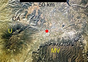
These rock formations are similar to those in other mountain ranges on the Colorado Plateau, like the Henry Mountains and the La Sal Range and the Abajo Mountains in Utah. However, the rocks in those Utah mountains are much younger, about 20 to 30 million years old. The Ute Mountains and the similar Carrizo Mountains in Arizona are part of an area called the Colorado Mineral Belt. But no valuable metal deposits have been found with these igneous rocks here.
Here are some of the layers of rock found in the area, from youngest to oldest:
- Rocks from the Cretaceous period
- Point Lookout Sandstone (the oldest part of the Mesa Verde Group)
- Mancos Shale
- Dakota Sandstone
- Burro Canyon Formation
- Rocks from the Jurassic period
- Morrison Formation
- Bluff Sandstone (used to be called Junction Creek Sandstone)
- Summerville Formation
- Entrada Sandstone
- Navajo Sandstone
In some places, the soft lower part of the Entrada Sandstone wears away into cool, rounded shapes called hoodoos. The Navajo Sandstone underneath it wears into rough, rounded surfaces, often with pits, and usually forms tall cliffs.
 | Aaron Henry |
 | T. R. M. Howard |
 | Jesse Jackson |


