
Four Corners Monument facts for kids

Four Corners Monument, after its 2010 reconstruction (New Mexico side)
|
|
| Coordinates | 36°59′56.325″N 109°2′42.67″W / 36.99897917°N 109.0451861°W |
|---|---|
| Location | The quadripoint in the Southwestern United States where the states of Arizona, Colorado, New Mexico, and Utah meet |
| Designer | |
| Type | Megalithic |
| Material | Granite and brass |
| Beginning date | 1868 |
| Completion date | 1912 |
| Opening date | 1931 |
| "Here meet in freedom under God four states" | |
The Four Corners Monument is a special place in the Southwestern United States. It marks the exact spot where four states meet: Arizona, Colorado, New Mexico, and Utah. This is the only place in the United States where four states come together at one point. Because of this, the area is called the Four Corners region.
The monument also sits on the border between two Native American governments. These are the Navajo Nation and the Ute Mountain Ute Tribe Reservation. The Navajo Nation takes care of the monument as a place for visitors. The idea for these state borders started around the time of the American Civil War. The United States Congress wanted to create governments in this area. They also wanted to stop slavery from spreading here.
When these early territories were formed, their borders were set using lines of latitude and longitude. Starting in the 1860s, these lines were carefully measured and marked. Even if there were small mistakes in these early measurements, the markers placed became the official legal borders. This means the Four Corners Monument is legally the corner for all four states.
Contents
Discover the Four Corners Monument
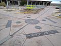
The Navajo Nation Parks and Recreation Department looks after the monument. It's a popular place for tourists to visit. The monument itself is a granite disk with a smaller bronze disk in the middle. Around this central point, you'll see smaller state seals and flags. These represent the four states and the Native American tribes in the area.
Words are written on the disk, circling the point. From Colorado, it reads: "Here meet in freedom under God four states." From New Mexico, it says: "In freedom under God four states here meet." From Arizona, it reads: "Under God four states here meet in freedom." And from Utah, it says: "Four states here meet in freedom under God."
Local Navajo and Ute artists often sell souvenirs and food nearby. You need to pay a small fee to enter and take pictures. Even though it's in a remote area, many people visit. As far back as 1908, people traveled long distances to take fun pictures. They would pose with their arms and legs in different states, or even kiss right over the center point.
Where is the Monument Located?

The monument is found on the Colorado Plateau. It's west of U.S. Highway 160, about 40 miles (64 km) southwest of Cortez, Colorado. Besides the four states, two self-governing Native American tribes also have borders here. These are the Navajo Nation and the Ute Mountain Ute Tribe Reservation. The Ute Mountain tribal borders match Colorado's borders at the monument.
Understanding the Climate
The Four Corners Monument is in a cold desert climate. This means winters are cold but sunny, and summers are hot and dry. The hottest temperature ever recorded was 105°F (41°C). This happened five times, in June and July of different years. The coldest temperature recorded was −18°F (−28°C) on January 3, 1974.
| Climate data for Four Corners National Monument (Arizona, Colorado, New Mexico, Utah) | |||||||||||||
|---|---|---|---|---|---|---|---|---|---|---|---|---|---|
| Month | Jan | Feb | Mar | Apr | May | Jun | Jul | Aug | Sep | Oct | Nov | Dec | Year |
| Record high °F (°C) | 69 (21) |
73 (23) |
82 (28) |
102 (39) |
99 (37) |
105 (41) |
105 (41) |
103 (39) |
97 (36) |
98 (37) |
79 (26) |
79 (26) |
105 (41) |
| Mean daily maximum °F (°C) | 42 (6) |
50 (10) |
58 (14) |
68 (20) |
78 (26) |
89 (32) |
93 (34) |
90 (32) |
82 (28) |
69 (21) |
54 (12) |
43 (6) |
68 (20) |
| Mean daily minimum °F (°C) | 20 (−7) |
26 (−3) |
33 (1) |
39 (4) |
48 (9) |
58 (14) |
64 (18) |
62 (17) |
54 (12) |
41 (5) |
30 (−1) |
22 (−6) |
41 (5) |
| Record low °F (°C) | −18 (−28) |
−11 (−24) |
8 (−13) |
17 (−8) |
27 (−3) |
38 (3) |
44 (7) |
40 (4) |
23 (−5) |
21 (−6) |
5 (−15) |
−14 (−26) |
−18 (−28) |
| Average precipitation inches (mm) | 0.73 (19) |
0.43 (11) |
0.65 (17) |
0.44 (11) |
0.62 (16) |
0.24 (6.1) |
0.96 (24) |
1.12 (28) |
0.72 (18) |
1.01 (26) |
0.59 (15) |
0.57 (14) |
8.08 (205.1) |
| Average snowfall inches (cm) | 3.4 (8.6) |
3.6 (9.1) |
1.4 (3.6) |
0.2 (0.51) |
0 (0) |
0 (0) |
0 (0) |
0 (0) |
0 (0) |
0.3 (0.76) |
0.9 (2.3) |
3.2 (8.1) |
13 (32.97) |
| Source: , | |||||||||||||
History of the Four Corners Borders


The land around Four Corners was first home to American Indian tribes. In the 1500s, Spain claimed it as part of New Spain. Later, Mexico took control after gaining independence from Spain in 1821.
After the Mexican–American War in 1848, the United States gained this land through the Treaty of Guadalupe Hidalgo. The first border that would become part of the monument was set in 1850. This was part of the Compromise of 1850, which created the New Mexico Territory and Utah Territory. The border between them was set at the 37th parallel north.
In 1861, the Colorado Territory was created. Land from the Utah Territory was given to Colorado. Colorado's southern border stayed at the 37th parallel north. A new border was made between Colorado and Utah. This line was based on the Washington meridian, a reference point used at that time.
Around 1860, before the American Civil War began, some people in southern New Mexico felt ignored by the government. They wanted to join the Confederate States of America. They called their area the Arizona Territory. The U.S. Congress responded in 1863 by creating another Arizona Territory. This new territory had different borders. The Union's plan eventually became real. This created the quadripoint we know today at Four Corners.
Surveying the Borders
After the Civil War, people started to measure and mark the actual borders. In 1868, a surveyor named Ehud N. Darling marked the border between Colorado and New Mexico. This is known as the "Darling Line."
In 1875, another surveyor, Chandler Robbins, marked the border between Arizona and New Mexico. He started near the Mexico–United States border and worked his way north. When he reached the 37th parallel north, he met the Darling Line. Here, he put up a sandstone marker. This sandstone marker is where the Four Corners Monument stands today.
In 1878, Rollin J. Reeves surveyed the border between Colorado and Utah. He found the sandstone marker placed by Robbins. From that point, he surveyed the border northward. In 1901, Howard B. Carpenter finished surveying the border between Arizona and Utah. This completed the survey of all the borders that meet at Four Corners. The markers placed during these surveys became the official legal boundaries between the states.
How the Marker Became a Monument

By 1899, the original sandstone marker was damaged. Two U.S. surveyors, Hubert D. Page and James M. Lentz, replaced it with a new stone. In 1912, a simple concrete pad was poured around this new marker.
The first modern Navajo government started in 1923. They wanted to manage the growing oil exploration on Navajo lands. They played a big part in developing the monument. In 1931, another surveyor, Everett H. Kimmell, found that this newer stone had also broken. He replaced it with a brass disk set in concrete.
In 1962, the Bureau of Land Management and the Bureau of Indian Affairs built an elevated concrete pad around the 1931 brass marker. This pad included the state border lines and names in tile. The monument was completely rebuilt in 1992. The 1931 brass marker was replaced with a new disk made of aluminum-bronze set in granite. The monument was rebuilt again in 2010, but the 1992 disk stayed in place.
Images for kids
-
A sign advises visitors: "Must Wear Mask!" in 2021 after the monument's reopening

See also
 In Spanish: Monumento de las Cuatro Esquinas para niños
