
Grand Valley (Colorado–Utah) facts for kids
Quick facts for kids Grand Valley |
|
|---|---|

A portion of the Grand Valley at dusk,
November 2013 |
|

Grand Valley
Location in Colorado

Grand Valley
Location in the United States
|
|
| Geography | |
| Country | United States |
| States | Colorado and Utah |
| County | Mesa County, CO and Grand County, UT |
The Grand Valley is a long, wide valley in the western United States. It stretches about 30 miles (48 km) (48 km) long and 5 miles (8.0 km) (8 km) wide. You can find it along the Colorado River in western Colorado and eastern Utah.
This valley is home to the city of Grand Junction. Smaller towns like Fruita and Palisade are also here. The Grand Valley is famous for growing lots of fruit, especially grapes for wine. It even has a special wine region called the Grand Valley AVA.
The valley gets its name from the "Grand River," which was the old name for the Colorado River in this area. The Grand Valley is the most populated part of western Colorado. Grand Junction acts like a main city for the region, similar to how Denver is on the eastern side of the Rocky Mountains. Major roads like Interstate 70 and U.S. Highway 6 pass through the valley. The Grand Valley is part of the larger Colorado Plateau desert lands.
What the Grand Valley Looks Like
The Grand Valley starts where the Colorado River gets wider. This is near the mouth of De Beque Canyon in the east. From there, the valley curves widely towards the west.
The Gunnison River, a big river that flows into the Colorado, joins it near Grand Junction. This happens about halfway through the valley.
Big flat-topped mountains called plateaus surround the valley. These include the Book Cliffs to the north and the Grand Mesa to the southeast. The Uncompahgre Plateau is to the southwest. The Colorado National Monument is also on a ridge on the southwest side of the valley. Much of the land around the valley is public land, managed by the Bureau of Land Management.
History of the Grand Valley
The name "Grand Valley" has been used for this area since the mid-1800s. The Colorado River above Grand Junction was called the Grand River as early as 1842. The city of Grand Junction got its name because it's where the Gunnison River and the Grand River (now Colorado River) meet.
Originally, the Green River and the Grand River joined in eastern Utah to form the Colorado River. However, the "Grand River" was officially renamed the Colorado River in 1921. This was done by the Colorado State Legislature.

Even with the name change, "Grand" is still part of many local names. You can find it in the Grand Valley itself, in Grand Mesa, and in Grand County, Colorado.
The Ute people (specifically the Parianuche band) lived in the valley for a long time. Settlers began moving into the area in the 1880s. They started farming different grains and fruits.
Around the 1890s, people found that sugar beets grown here had a lot of sugar. This made sugar beets a very important crop, along with other fruits and vegetables. In 1890, Governor George A. Crawford planted a 60 acres (24 ha) (24 hectare) wine vineyard in the valley. By 1900, there were over 1,000 farms growing wine grapes. Records show that 1,744 gallons of wine were sold that year!
In the early 1900s, new ways to dry fruit helped farmers send their products to faraway markets. This caused fruit growing to really expand in the valley. In 1918, the Government Highline Canal was finished. This canal brought water to help grow crops on 50,000 acres (20.0 km²) of land in the valley. The project also included a special type of dam called a roller dam in De Beque Canyon. It was one of the largest of its kind in the country.
Images for kids
-
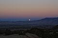
A portion of the Grand Valley at dusk, November 2013
-
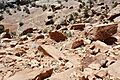
Sandstone rocks and formations are common on the Colorado Plateau desert lands, November 2013
See also
 In Spanish: Gran Valle para niños
