
Gunnison River facts for kids
Quick facts for kids Gunnison River |
|
|---|---|

The Gunnison River in Black Canyon of the Gunnison National Park.
|
|

Map of the Gunnison River, its tributaries and major cities
|
|
| Country | United States |
| State | Colorado |
| Cities | Gunnison, Grand Junction |
| Physical characteristics | |
| Main source | East River confluence with the Taylor River 8,008 ft (2,441 m) 38°39′49″N 106°50′50″W / 38.66361°N 106.84722°W |
| River mouth | Colorado River 4,552.56 ft (1,387.62 m) 39°3′42″N 108°34′42″W / 39.06167°N 108.57833°W |
| Length | 180 mi (290 km) |
| Basin features | |
| Basin size | 7,923 sq mi (20,520 km2) |
| Tributaries |
|
The Gunnison River is a major river in western Colorado. It is one of the biggest rivers that flows into the Colorado River. The Gunnison River is about 180 miles (289 km) long. It flows from east to west.
The river collects water from a huge area, about 7,923 square miles (20,520 km2). This area includes different natural places like forests and high mountain meadows. These areas are located near the Continental Divide. As the river flows west, it cuts through the San Juan Mountains. Finally, it joins the Colorado River at Grand Junction.
The Gunnison River area is a popular spot for fun outdoor activities. People enjoy fishing, rafting, boating, camping, hiking, and rock climbing there.
Contents
River Features and Flow

The Gunnison River starts when two other rivers, the Taylor River and the East River, meet. This happens at Almont in eastern Gunnison County, Colorado.
Just past the town of Gunnison, the river widens into a large lake called Blue Mesa Reservoir. This lake is about 36 miles (58 km) long. It was formed by the Blue Mesa Dam. Here, the Gunnison River also gets water from the Lake Fork of the Gunnison.
The river is dammed two more times downstream. These dams create Morrow Point Reservoir and then Crystal Reservoir. These reservoirs help make electricity and provide water for towns and farms nearby. Below Crystal Dam, the Gunnison River flows through powerful rapids.
The Black Canyon
After the dams, the Gunnison River flows through the Black Canyon of the Gunnison. This canyon is one of the longest, narrowest, and deepest gorges in the world. It is a truly amazing natural wonder.
At the end of the Black Canyon, the Gunnison River is joined by the North Fork River. Farther downstream, near Delta, Colorado, the Uncompahgre River flows into it. The Gunnison then winds through desert canyons, where it receives Kannah Creek.
Finally, the river leaves Dominguez Canyon and flows into the Colorado River at Grand Junction. Some years, the Gunnison River has as much water as the Colorado River at this meeting point.
The Gunnison River can be anywhere from 100 to 1,000 feet wide. Its depth ranges from 3 to 50 feet. The river's strong current and many rapids make it very hard to travel upstream.
Small boats can travel on most parts of the river. Larger boats can go on the river below the Black Canyon. However, some parts of the Black Canyon are too dangerous for any type of boat because of giant rapids. Only very experienced boaters should try to navigate the entire canyon.
River History
The first non-native person to see and write about the Gunnison River was Juan Maria de Rivera. He reached the river in 1761 and again in 1765. This was just below where it meets the Uncompahgre River.
Later, in 1776, Silvestre Vélez de Escalante also saw the river. At that time, the Spanish name for the river was Rio de San Javier. Native Americans called it Tomichi.
Through the mid-1800s, the river had many different names. These included the Eagle, Eagle Tail, South Fork of the Grand, Grande, and Grand River. However, in later years, the river was renamed after U.S. Army Captain John W. Gunnison. He was a Topographic Engineer who was killed in 1853 while mapping a trail in Utah Territory.
Fishing in the Gunnison
The lower part of the Gunnison River is known for excellent fishing. It is called "Gold Medal Water" and "Wild Trout Water." This special area starts about 200 yards below the Crystal Dam. It continues through the Gunnison Gorge to where the North Fork and Gunnison Rivers meet.
Engineering and Water Use
Some of the Gunnison River's water is moved to help water farms in the Uncompahgre Valley. This happens through the Gunnison Tunnel, which is about 5 miles (8 km) long. This tunnel was built between 1905 and 1909.
The Blue Mesa Dam, Morrow Point Dam, and Crystal Dam were built between the 1960s and 1970s. These dams are part of a bigger plan called the Colorado River Storage Project.
River Health and Pollution
The Gunnison River has faced issues with pollution, mainly from selenium and mercury. This pollution comes from a few sources. One is the natural soil in the area, which is high in selenium. When farms irrigate these soils, selenium can wash into the river. Mining activities and mercury from the air also add to the problem.
This pollution is a big concern for certain fish species that live in the river. These include the bonytail chub, Colorado pikeminnow, humpback chub, and the razorback sucker. The lower Gunnison River is a very important home for these fish.
Selenium in the River
The high levels of selenium in the Gunnison River come from the natural rock underneath. This rock is called the Mancos Shale, and it naturally has a lot of selenium. When the rock breaks down, the selenium gets into the soil.
Farming in the Gunnison River Basin is a big reason why selenium gets into the river. When farmers water their fields, the water can carry selenium from the soil into the river. Some parts of the river, especially near Grand Junction and in smaller streams that flow into the Gunnison, have very high selenium levels.
Selenium levels in the river usually go up from April and reach their highest in August. This happens because of water draining from farms. These high levels of selenium happen at the same time that fish like the Colorado pikeminnow and the razorback sucker are reproducing. High selenium can harm fish, affecting their breathing and energy. It can also cause problems with how adult fish develop.
Mercury in the River
Mercury in the Gunnison River comes from human activities. These include surface mining and burning things like coal. When it rains, the rainwater can carry mercury into the river. Once in the water, tiny living things called bacteria can change mercury into a more harmful form called methylmercury.
Methylmercury is not good for living things. It can build up in the bodies of animals and become more concentrated as it moves up the food chain. This means that fish at the top of the food chain can have very high levels of mercury.
Fish like the humpback chub, bonytail chub, Colorado pikeminnow, and the razorback sucker are especially at risk. This is because they travel long distances each year to reproduce. The Colorado pikeminnow is very vulnerable because it lives a long time and travels very far.
Working to Clean the River
Many groups in Colorado are working together to clean up the Gunnison River. Their goal is to make the river a better home for fish like the razorback sucker and the Colorado pikeminnow.
Some of these efforts include The Gunnison River Basin's Selenium Management Plan and the Bureau of Reclamation's Gunnison Basin Selenium Management Program. These plans aim to lower the amounts of selenium and salt in the river. Too much salt can also harm fish reproduction and farming.
Since the 1980s, these efforts have helped reduce selenium levels by 43%. But more work is still needed. One way they are helping is by giving money to farmers in the Gunnison River Basin. This helps farmers reduce the amount of soil and selenium that washes into the river.
To reduce salt, old water systems are being updated to direct pipelines and sprinklers. This helps reduce how much water runs off into the Gunnison River. Less runoff means less selenium from farm irrigation gets into the river.
Because of climate change, the amount of water flowing in the Gunnison River is expected to decrease. This could cause selenium and mercury levels to rise even more. So, water managers are looking for ways to lessen the impact of climate change. Their plans include making water systems stronger, preventing water shortages for farms, and supporting good relationships between farming, nature, and recreation.
The Colorado Department of Public Health and Environment has also received nearly $13 million to help with future research and pollution control. Soon, state water quality officials will check the Gunnison River. They want to see if the cleanup programs have successfully lowered the selenium and salt levels. If selenium levels are still too high, the river might be reclassified, meaning it needs even more protection.
Images for kids
-
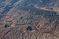
An aerial photograph of Gunnison River, November 2014

See also
 In Spanish: Río Gunnison para niños
