
Mancos Shale facts for kids
Quick facts for kids Mancos ShaleStratigraphic range: Mid Albian-Campanian ~110–80Ma |
|
|---|---|

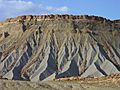
Mancos Shale badlands in Capitol Reef National Park, southern Utah.
|
|
| Type | Geologic formation |
| Sub-units | See text |
| Underlies | Mesaverde Formation |
| Overlies | Dakota Group |
| Lithology | |
| Primary | Shale |
| Location | |
| Coordinates | 37°21′09″N 108°17′49″W / 37.3525426°N 108.2969254°W |
| Region | Arizona, Colorado, New Mexico, Utah, Wyoming |
| Country | |
| Extent | Basin and Range, Colorado Plateau & San Juan Mountains Provinces |
| Type section | |
| Named for | Mancos, Colorado |
The Mancos Shale is a special type of rock layer found in the Western United States. It formed a long, long time ago during the Cretaceous period, which was when dinosaurs roamed the Earth!
It was first studied and named in 1899 by scientists Cross and Purington. They named it after the town of Mancos, Colorado, where they found good examples of this rock.


Contents
What is Mancos Shale?
The Mancos Shale is mostly made of a type of rock called mudrock. This mudrock formed at the bottom of a huge ancient sea, called the Western Interior Seaway. This sea covered much of North America millions of years ago!
The Mancos Shale was laid down between about 95 and 80 million years ago. This was during the Late Cretaceous period.
Scientists study the layers of rock, which is called stratigraphy. The Mancos Shale is found between two other important rock groups: the Dakota Group below it and the Mesaverde Formation Group above it.
The Mancos Shale sits directly on top of the Dakota Group. As you go higher in the Mancos Shale, it slowly changes and mixes with the Mesaverde Group.
Where is Mancos Shale Found?
The Mancos Shale is found in several large areas in the western U.S. These include the Basin and Range Province, the Colorado Plateau Province, and the San Juan Mountains Province.
In Basins
You can also find the Mancos Shale in many large bowl-shaped areas called structural basins. Some of these include:
- Black Mesa Basin
- Estancia Basin
- Green River Basin
- Orogrande Basin
- Paradox Basin
- Piceance Basin
- San Juan Basin
- Uintah Basin
Different Layers of Mancos Shale
The Mancos Shale is very thick and spread out. Because of this, scientists have given different names to its smaller parts or layers. These layers are called "subunits" or "members."
Some of these subunits are named after places where they are found. For example, the Fairport Member and Blue Hill Member are important layers found in Colorado.
Images for kids
-
Mancos Shale badlands in Capitol Reef National Park, southern Utah.
-

Tununk Member of the Mancos Shale below the capping Ferron Sandstone Member. West side of the San Rafael Swell, Emery County, Utah.
