Mancos, Colorado facts for kids
Quick facts for kids
Mancos, Colorado
|
|
|---|---|

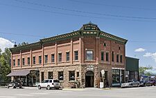
The 1905 Bauer Bank Block building in Mancos
|
|
| Nickname(s):
Gateway to Mesa Verde
|
|

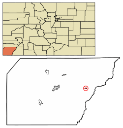
Location in Montezuma County, Colorado
|
|
| Country | United States |
| State | |
| County | Montezuma |
| Founded | 1894 |
| Incorporated (town) | November 30, 1894 |
| Government | |
| • Type | Statutory Town |
| Area | |
| • Total | 0.638 sq mi (1.65 km2) |
| • Land | 0.638 sq mi (1.65 km2) |
| • Water | 0.00 sq mi (0 km2) |
| Elevation | 7,011 ft (2,137 m) |
| Population
(2020)
|
|
| • Total | 1,196 |
| • Density | 1,874.6/sq mi (723.8/km2) |
| Time zone | UTC-7 (Mountain (MST)) |
| • Summer (DST) | UTC-6 (MDT) |
| ZIP code |
81328
|
| Area code(s) | 970 |
| FIPS code | 08-48115 |
| GNIS feature ID | 2412939 |
Mancos is a small town in southwestern Colorado, United States. In 2020, about 1,196 people lived there. It's located right at the entrance to Mesa Verde National Park, which is why it's known as the "Gateway to Mesa Verde."
Mancos is surrounded by beautiful rangeland and mountains. This makes it a great place for outdoor activities. The town was founded in 1894. It's near where early Spanish explorers first crossed the Mancos River. Mancos is the main business hub for eastern Montezuma County. It is served by U.S. Route 160 and Colorado State Highway 184.
Contents
History of Mancos
Early Inhabitants: Ancient Pueblo People
People have lived in the Mancos Valley since at least the 10th century AD. These early residents were the ancient Pueblo people, sometimes called the Anasazi. Around the late 1200s, they left the area. This might have been because of tough weather conditions or for safety.
The Mancos area has many old archaeological sites. These include single houses and small village complexes. The people living in the Mancos Valley likely moved to the cliff dwellings at Mesa Verde. This move may have been for defense or due to changes in the climate.
Important ancient Pueblo sites in the area include:
- Bement site: This site shows homes from two different Pueblo periods. From AD 750-850, there was one shelter. Later, from 1000 to 1150, a group of six buildings was used.
- Lost Canyon Archeological District: This area might have been the northern edge of the Mesa Verde ancient Pueblo people's territory from about AD 1000–1300.
Native American Tribes and Spanish Explorers
For hundreds of years, the Navajo and Ute people tribes fought over control of this land. Spanish friars and soldiers traveled through the area in the 1700s. They were using the Old Spanish Trail to connect New Mexico and California.
The name "Mancos" comes from the Domínguez–Escalante expedition of 1776. The exact reason for the name is not fully clear. Some stories say it refers to the Spanish explorers' horses becoming "crippled" (mancos in Spanish) after crossing the San Juan Mountains. The horses supposedly got better after eating the rich grass in the Mancos Valley. The expedition crossed the Mancos River somewhere in the town.
Mancos in the 1800s and 1900s
The Old Spanish Trail was an important trade route. It passed through the Mancos area from 1829 to the 1850s.
In 1868, Mancos was part of the original Ute Reservation. But in 1873, it became part of the San Juan Cession. Soon after, cattle ranchers started settling in the Mancos Valley in the 1870s. They provided cattle to the mining towns in the San Juan Mountains and La Plata Mountains. Today, the Ute Mountain Indian Reservation is about 6 miles (9.7 km) south of Mancos.
When Mancos was founded, it was the main trading center for eastern Montezuma County. It was even bigger than Cortez, which is now the county seat. In the 1890s, Mancos became a stop on the Rio Grande Southern Railroad. This railroad connected Durango to the east with the Telluride mining areas to the north. Ranchers in the Mancos Valley continued to supply food and wood to the mining camps. Later, Latter-day Saints colonists moved in. They started farms and small communities.
Local farmers and ranchers began building irrigation canals in the late 1870s and 1880s. These canals brought water from the Mancos River to their farms. By the early 1900s, a large network of irrigation ditches was working. This system is still used today. In the 2000s, a big project helped replace many open ditches with pipes. This saves water and prevents salt pollution. Many of the original irrigation ditches are now considered historic sites.
Mancos became an official town in 1894. The town government quickly started making improvements. They built boardwalks and banned fast riding in town. A water and electrical system was built in 1904. A new bridge was added in 1905, and concrete sidewalks in 1909. However, most side streets in town are still unpaved.
The railroad stopped running in the 1950s. This allowed U.S. Route 160 to be moved to its current path. The creation of Mesa Verde National Park also helped Mancos grow.
Several historic buildings in Mancos are listed on state or national registers:
- The Bauer Bank Building: Built in 1905, it's the oldest brick building in the Mancos Valley.
- The Bauer House: Built in 1889 for George Bauer, a key businessman in Mancos.
- Mancos High School: Built in 1909 from local sandstone, it was the first high school in the county.
- The Mancos Opera House: Completed in 1910.
- The Wrightsman House: Built in 1903 in the late Victorian style.
In the mid-1900s, there were attempts to create a separate Mancos County. These efforts did not succeed. The Mancos Project in the 1950s helped farming and tourism. This project created Jackson Reservoir, which is now Mancos State Park. This reservoir also provides water for the town and Mesa Verde National Park.
Recently, Mancos has become a popular place for artists. Aramark, the company that runs services at Mesa Verde National Park, has facilities in town. There's also a special sawmill that processes aspen wood. Many events are held each year, like Mancos Days in July, a motorcycle rally in September, and a balloon festival. Much of the farmland around Mancos has been divided into smaller properties. This has led to more people moving to the area. A new public library was built in 2008.
Geography and Location
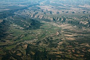
Mancos is located in the eastern part of Montezuma County, Colorado. The town sits in the Mancos River valley. It is about 7,000 feet (2,100 meters) above sea level. The Mancos River was named by Spanish explorers. Rio de los Mancos means "River of the Sleeve." This might refer to how the river flows through narrow canyons.
The town's skyline is dominated by Mesa Verde to the west. Menefee Mountain is to the southeast. The La Plata Mountains are to the east and northeast. The Mancos River starts in these mountains.
Mancos was originally built as a railroad town. It stretches for about a mile along both sides of the river. Newer areas are north of the old railroad line, which is now U.S. Route 160. This highway is part of the San Juan Skyway and the Old Spanish Trail. The main business area is along Business Route 160 (Grand Avenue). Newer businesses are along the main highway.
US 160 goes west about 18 miles (29 km) to Cortez, the county seat. It goes east about 27 miles (43 km) to Durango. Colorado State Highway 184 goes northwest from Mancos about 18 miles (29 km) to Dolores.
The Mancos River flows through the town from east to west. Then it flows south into Mancos Canyon. This canyon is on the west and south side of Mesa Verde. Much of the town is in a flood zone.
About 5 miles (8.0 km) northeast of town is Mancos State Park. It's located on Jackson Gulch Reservoir. This reservoir was built by the Mancos Irrigation Project. Other activities around Mancos include Nordic skiing at Echo Basin and various vacation resorts.
Many government services in Colorado are provided by special districts. These include the Mancos Library District, Mancos Water Conservancy District, and Mancos Fire Protection District. The fire district also provides emergency medical services. The closest hospitals are in Cortez (about 18 miles or 29 km west) and Durango (about 34 miles or 55 km east). Mancos does have a medical clinic.
The nearest airport for general and commercial flights is southwest of Cortez. It's about 22 miles (35 km) west of Mancos. There are some private airstrips nearby, but they are not open to the public.
Climate
| Climate data for Mancos, Colorado (1991–2020 normals, extremes 1898–1919, 1990–present) | |||||||||||||
|---|---|---|---|---|---|---|---|---|---|---|---|---|---|
| Month | Jan | Feb | Mar | Apr | May | Jun | Jul | Aug | Sep | Oct | Nov | Dec | Year |
| Record high °F (°C) | 64 (18) |
67 (19) |
76 (24) |
82 (28) |
92 (33) |
96 (36) |
96 (36) |
95 (35) |
93 (34) |
83 (28) |
72 (22) |
63 (17) |
96 (36) |
| Mean maximum °F (°C) | 52.0 (11.1) |
56.2 (13.4) |
66.8 (19.3) |
73.7 (23.2) |
81.9 (27.7) |
89.8 (32.1) |
92.6 (33.7) |
89.0 (31.7) |
84.9 (29.4) |
76.3 (24.6) |
65.6 (18.7) |
54.2 (12.3) |
92.9 (33.8) |
| Mean daily maximum °F (°C) | 40.0 (4.4) |
43.7 (6.5) |
52.9 (11.6) |
60.8 (16.0) |
69.9 (21.1) |
80.8 (27.1) |
85.0 (29.4) |
82.3 (27.9) |
75.1 (23.9) |
63.9 (17.7) |
51.0 (10.6) |
40.5 (4.7) |
62.2 (16.8) |
| Daily mean °F (°C) | 26.2 (−3.2) |
30.3 (−0.9) |
37.8 (3.2) |
44.3 (6.8) |
52.4 (11.3) |
61.8 (16.6) |
67.8 (19.9) |
65.9 (18.8) |
58.3 (14.6) |
47.4 (8.6) |
36.3 (2.4) |
27.3 (−2.6) |
46.3 (7.9) |
| Mean daily minimum °F (°C) | 12.4 (−10.9) |
17.0 (−8.3) |
22.7 (−5.2) |
27.8 (−2.3) |
34.9 (1.6) |
42.8 (6.0) |
50.5 (10.3) |
49.4 (9.7) |
41.6 (5.3) |
31.0 (−0.6) |
21.5 (−5.8) |
14.0 (−10.0) |
30.5 (−0.8) |
| Mean minimum °F (°C) | −5.4 (−20.8) |
−1.1 (−18.4) |
7.3 (−13.7) |
15.3 (−9.3) |
23.2 (−4.9) |
31.9 (−0.1) |
42.1 (5.6) |
42.2 (5.7) |
29.2 (−1.6) |
16.3 (−8.7) |
4.4 (−15.3) |
−5.3 (−20.7) |
−8.8 (−22.7) |
| Record low °F (°C) | −24 (−31) |
−26 (−32) |
−7 (−22) |
1 (−17) |
11 (−12) |
21 (−6) |
30 (−1) |
30 (−1) |
16 (−9) |
1 (−17) |
−9 (−23) |
−21 (−29) |
−26 (−32) |
| Average precipitation inches (mm) | 1.38 (35) |
1.27 (32) |
1.14 (29) |
1.04 (26) |
1.04 (26) |
0.58 (15) |
1.64 (42) |
1.79 (45) |
1.90 (48) |
1.42 (36) |
1.22 (31) |
1.25 (32) |
15.67 (398) |
| Average snowfall inches (cm) | 14.7 (37) |
12.8 (33) |
6.6 (17) |
3.5 (8.9) |
0.9 (2.3) |
0.0 (0.0) |
0.0 (0.0) |
0.0 (0.0) |
0.0 (0.0) |
0.6 (1.5) |
5.2 (13) |
12.8 (33) |
57.1 (145) |
| Average precipitation days (≥ 0.01 in) | 7.6 | 7.4 | 6.5 | 5.6 | 6.0 | 3.6 | 9.6 | 10.5 | 7.5 | 6.3 | 5.5 | 7.0 | 83.1 |
| Average snowy days (≥ 0.1 in) | 5.8 | 4.7 | 3.3 | 1.5 | 0.4 | 0.0 | 0.0 | 0.0 | 0.0 | 0.3 | 2.6 | 5.2 | 23.8 |
| Source: NOAA | |||||||||||||
People in Mancos
| Historical population | |||
|---|---|---|---|
| Census | Pop. | %± | |
| 1900 | 383 | — | |
| 1910 | 567 | 48.0% | |
| 1920 | 682 | 20.3% | |
| 1930 | 646 | −5.3% | |
| 1940 | 748 | 15.8% | |
| 1950 | 785 | 4.9% | |
| 1960 | 832 | 6.0% | |
| 1970 | 709 | −14.8% | |
| 1980 | 870 | 22.7% | |
| 1990 | 842 | −3.2% | |
| 2000 | 1,119 | 32.9% | |
| 2010 | 1,336 | 19.4% | |
| 2020 | 1,196 | −10.5% | |
| U.S. Decennial Census | |||
Population in 2020
In 2020, there were 1,196 people living in Mancos.
- 80.6% were White.
- 4.4% were Native American.
- 15.1% were of Hispanic or Latino background.
There were 588 homes in the town.
Population in 2010
In 2010, Mancos had 1,336 people. There were 546 households.
- 85.4% of the people were White.
- 6.3% were Native American.
- 12.3% were of Hispanic or Latino background.
About 26.6% of the population was under 18 years old. The average age was 38 years.
Getting Around Mancos
Mancos is part of Colorado's Bustang bus system. You can catch the Durango-Grand Junction Outrider line here.
Famous People from Mancos
- Luther Elliss: A former professional football player (defensive end).
- Jaye P. Morgan: A retired singer, born in Mancos in 1931.
- Louisa Wade Wetherill: A famous explorer and trader.
Sister City
Mancos has a sister city, which is a town it shares a special friendship with:
 Feins, Ille-et-Vilaine, Brittany, France
See also
 In Spanish: Mancos (Colorado) para niños
 | DeHart Hubbard |
 | Wilma Rudolph |
 | Jesse Owens |
 | Jackie Joyner-Kersee |
 | Major Taylor |


