
Rangeland facts for kids


Rangelands are large outdoor areas where animals can graze. These places include grasslands, shrublands, woodlands, wetlands, and even deserts. Both wild animals and farm animals like cattle use rangelands for food.
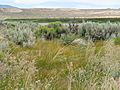
Some common types of rangelands are tallgrass and shortgrass prairies, desert grasslands, savannas, steppes, and tundras. Rangelands are different from regular pastures. Pastures are usually planted by people, but rangelands mostly have natural plants.
People manage rangelands using methods like controlled grazing by animals or planned fires. They don't usually plant seeds, irrigate, or use fertilizers like on farms.
Grazing is a key way rangelands are used. Animals eating plants helps manage the land. It can produce livestock, change the types of plants growing, or even reduce plants that could cause big fires.
Fire is also very important for rangelands. Fires, whether started by lightning or by people on purpose, help control the plants. They often reduce the number of woody plants like trees and shrubs. This allows more grasses and other soft plants to grow. If fires are stopped, trees and shrubs can take over, leaving less space for grasses.
Contents
Exploring Different Rangeland Types
The United States Environmental Protection Agency says rangelands are lands where the main plants are grasses, grass-like plants, or shrubs that animals can eat. They include natural grasslands and savannas. Sometimes, wetlands, deserts, and tundras are also counted as rangelands.
What is a Prairie?
Prairies are a type of rangeland found in temperate grasslands. They have a moderate climate and rainfall. Grasses, herbs, and shrubs are the main plants, not many trees. Famous prairies include the Pampas in Argentina and the steppes of Eurasia.
Understanding Grasslands
Grasslands are areas mostly covered by different types of grasses. You can also find other soft, non-woody plants there. Grasslands exist naturally on every continent except Antarctica. In cooler places like Europe and North America, grasslands often have perennial bunch grasses. In warmer areas, annual grasses are more common.
Discovering the Steppe
A Steppe is a flat, grassy area with very few trees. Any trees you see are usually near rivers or lakes. The prairie is a type of steppe. Steppes can be semi-desert or covered with grass and shrubs. It depends on the season and how far north or south they are. This term also describes climates that are too dry for forests but not dry enough to be a full desert.
The Pampas of South America
The Pampas are very fertile lowlands in South America. They cover a huge area of over 750,000 square kilometers (290,000 square miles). This includes parts of Argentina, Uruguay, and Brazil. The land is mostly flat, with only a few low hills. The climate is mild, with good rainfall throughout the year. This makes the soil great for agriculture. The Pampas are home to unique wildlife like the rhea, the badger, and the prairie chicken.
Exploring Shrublands
Shrubland is a plant area where shrubs are the main type of plant. You might also find grasses and herbs there. Shrublands can happen naturally or because of human activities. They can be a stable type of plant community that stays the same over time. Or, they can be a temporary community that appears after something like a fire. Regular natural events like fire or animals eating plants can help keep shrublands stable.
What is a Woodland?
A Woodland is a type of forest where the trees are not very dense. This means there's lots of sunlight and not much shade. Woodlands often have shrubs and grasses growing underneath the trees. Woodlands can be a transition area to shrubland in drier conditions. If there are many trees close together, creating a lot of shade, it's usually called a forest.
Understanding Savannas
A Savanna is a grassland where the trees are small or spread far apart. This means the tree tops don't close together. Because of this open space, plenty of sunlight reaches the ground. This sunlight helps a continuous layer of grasses grow.
Describing Deserts
A Desert is a very dry place that gets very little rain. Deserts usually receive less than 250 millimeters (10 inches) of rain each year. Also, more water evaporates from the land than falls as rain. Deserts can be hot or temperate.
The Cold Tundra
Tundra is a cold area where trees can't grow well. This is because of low temperatures and very short growing seasons. The word tundra comes from a word meaning "treeless mountain tract." There are three types of tundra: Arctic, alpine tundra, and Antarctic. In tundra, the plants are small shrubs, sedges, grasses, mosses, and lichens. Some tundra areas might have a few scattered trees. The border between the tundra and the forest is called the tree line.
Images for kids
-
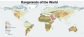
A map showing the world's rangelands, and areas that are not rangeland
-
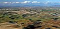
Palouse Hills of Washington
-
Sonoran Desert
-
Konza Prairie
-
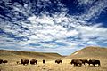
Buffalo grazing on rangeland in Crook County, Wyoming.
-
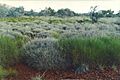
Triodia Hummock Grasslands
-
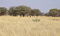
Savannah in southern Africa
-
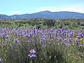
Caliente Peak, California
-
Lake Swan, Nevada


